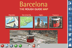
Rough Guides Map Barcelona... These guides are a series of fantastic interactive maps.
Produced in conjunction with the premier travel publisher Rough Guides.
Discover and explore Barcelona using full colour interactive linked maps, in this simple to use PDA version of The Rough Guides Barcelona.
Find all the top tourist spots and key attractions with ease, information on the city and its sights can be quickly displayed with links to photographs and map locations. All in a superb easy to use interface.
If you''re travelling to Barcelona, be sure you don''t leave home without this guide on your PDA.
The Rough Guide city maps includes:
Fully scrollable and interactive maps of the city.
Tap any location to display information and available links.
Intuitive navigation bar meaning you are never more than one click away from the information you require.
Map links allow you to directly link to other maps, photographs, or detailed views.
Categorised Find feature allowing you to quickly find any street, place of interest or station.
Categorised Information feature providing a wealth of information on the city, places of interest, etc.
1-Click Home feature, keeping the Home map always at hand.
Zoom function on all maps.
Special Offer Only $20.00
Hi Res & landscape displays supported.
Like it? Share with your friends!
If you got an error while installing Themes, Software or Games, please, read FAQ.
Supported operating systems:
Pocket PC 2002, Windows Mobile 2003, Windows Mobile 5.0, Windows Mobile 6 Classic, Windows Mobile 6 Professional, Windows Mobile 6.1 Classic, Windows Mobile 6.1 Professional, Windows Mobile 6.5 Professional
Similar Software:
Google Maps Mobile Google Maps Mobile - Cruising around looking for a nearby coffee shop? Driving to that new restaurant but can't remember which street to turn right on? Now you can get business locations, maps and directions while you're on the go. And it's all free.
Real-time traffic
See where the congestion is, and estimate delays in over 30 major US metropolitan areas
Travel Berlin, Germany - Illustrated Guide, Phrasebook and Maps. Travel Berlin, Germany - an illustrated city guide, phrasebook, and maps. Indulge Yourself with a personal tour guide on Your PDA. FREE General Information chapter and a map in the trial version.
Features
Fully illustrated.
Historical overviews.
Interesting facts.
Street Map, Transportation Maps, and more.
Museums hours and tickets info
Travel Hawaii Travel Hawaii an illustrated travel guide, phrasebook, and maps. Indulge Yourself with a personal tour guide on Your PDA. FREE General Information, basic phrasebook, and a map in the trial version.
Features
Fully illustrated.
City attractions.
Historical overviews.
Interesting facts.
Street Maps, Phrasebook, and more
amAze (Motorola) AmAze is a first of its kind free navigation and local search service. It is free to download and use and it contains wide coverage of maps including aerial photo in Europe, North America, Australia and parts of Asia and Africa
Map of Beijing (Chinese) / China for City Advisor Map of Beijing (Chinese) / China for City Advisor is a Chinese version of Beijing Metro map. Type the first letter of Pinyin to search.
Instructions:
1. Download the map (zip file)
2. Extract the files in /CityAdvisor/maps
3. Open CityAdvisor -> Maps icon -> Menu -> Refresh
4
Travel Europe - A complete Guide, Road maps, and Phrasebook By Rick Steve Travel Europe - Rick Steves doesn't just list where to travel in Europe, he gives travelers inside information on where to stay, what to visit, and how to get there -- economically and hassle-free. With Rick Steves as their guide, travelers can delve into European culture, make friends with the locals, and experience everything Europe has to offer
Rough Guides Map Rome Rough Guides Map Rome... These guides are a series of fantastic interactive maps.
Produced in conjunction with the premier travel publisher Rough Guides.
Discover and explore Rome using full colour interactive linked maps, in this simple to use PDA version of The Rough Guides Rome
Tube London City Streets (2009 Edition) Tube London City Streets
This Tube package consists of a fully scrollable detailed map of the London Underground system and 9 linked GPS enabled A-Z street maps.
Plan journeys on the London Underground system, list details of the quickest routes and see a superb animated display of your journey tracking around the system map
Other Software by developer «Visual IT»:
Tube 2 Atlanta (UIQ) Tube 2 Atlanta (UIQ) - This map package for Tube 2 consists of a fully scrollable detailed map of the Atlanta rail system.
Plan journeys on this system, list details of the quickest routes and see a superb animated display of your journey tracking around the system map
GB Major Road Atlas (Palm OS) GB Major Road Atlas (Palm OS) - This map package is an essential addition to your Tube 2 maps if you drive in and around Great Britain.
This reference map gives you a clear view of all the major roads in the whole of Great Britain, you can use the quick find feature to locate any of the 30,000 + GB towns and villages in the database
Boston Subway by Zuti Boston Subway by Zuti - The new Boston Subway map makes it easy to travel in and around the city using the MBTA Subway, MBTA Commuter Rail, MBTA Boats, and Massport shuttle buses
Great Britain Rail for iPad by Zuti Great Britain Rail for iPad by Zuti - The new Great Britain Rail map makes it easy to travel in and around the country using the rail services. This application contains a geographically accurate map of the whole of Great Britain allowing you to easily view the route of any journey
Tube 2 London (UIQ3) Tube 2 London (UIQ3) - This map package for Tube 2 consists of a fully scrollable detailed map of the London Underground system.
Plan journeys on the London Underground system, list details of the quickest routes and see a superb animated display of your journey tracking around the system map
Tube Nottingham Streets Tube Nottingham Streets - A complete street map of central Nottingham for your Palm device using superb map tiles from the famous A-Z map company.
These maps plug directly into our new Tube engine and are a convenient replacement for your paperback A-Z. Never get lost in Nottingham again
London Central Bus 10 London Central Bus 10 - The new Zuti London Bus map has finally arrived, making it easy to travel by bus anywhere in central London. This clear and colourful map covers a detailed street level area of 6 miles by 4 miles and includes over 1300 bus stops and 189 bus routes
Tube Hamburg (Seris 60) Tube Hamburg (Seris 60) - Our highly acclaimed Tube application that guides you around the metro system of Hamburg is now available for your Series 60 Symbian powered phone. An essential addition to your phone for locals and tourists alike.
· A detailed clear colour map of the Hamburg metro (S-Bahn / U-Bahn) system fully scrollable
Paris Metro for iPad by Zuti Paris Metro 10 - This Zuti application contains a visually unique map of the Paris transport system and a superb animated journey planner to help you get around the Metro, RER, SNCF, Tram, Tvm, and Vogueo services. Now revised and updated to include a larger geographic area which covers more of the outlying areas surrounding Paris
Tube Lisbon (Series 60) Tube Lisbon (Series 60) - Our highly acclaimed Tube application that guides you around the rail system of Lisbon is now available for your Series 60 Symbian powered phone. An essential addition to your phone for locals and tourists alike.
· A detailed clear colour map of the Lisbon rail system fully scrollable.
· Quick find station utility


 Hi Res & landscape displays supported.


 / Belgium (Belgique) for City Advisor")
")
 / China for City Advisor")


")
")
")


")


")

")