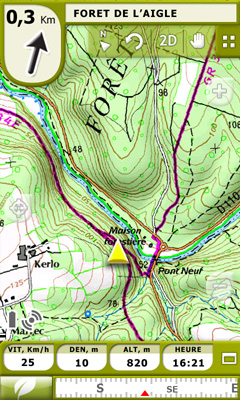
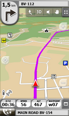
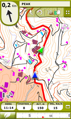
TwoNav for Windows Mobile - A dual navigation system (On-Road/Off-Road) to perform most of your outdoor activities (hiking, biking, skiing, geocaching, ...). TwoNav can also guide you when driving. A single solution for all your orientation needs.
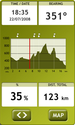
Load maps, tracks, routes and waypoints and get ready for your trip! - Save your performances by recording them as tracks (performance’s information is being controlled by more than 60 on-screen stats).
E-Roadbooks, data field alarms, Virtual Coach, Man Over board...It doesn’t matter which is your activity, TwoNav will cover all your needs!
· 15 days trial
Like it? Share with your friends!
If you got an error while installing Themes, Software or Games, please, read FAQ.
Supported operating systems:
Windows Mobile 6 Classic, Windows Mobile 6 Professional, Windows Mobile 6.1 Classic, Windows Mobile 6.1 Professional, Windows Mobile 6.5 Professional
Similar Software:
BackCountry Navigator BackCountry Navigator is fun-filled navigation software for the outdoor adventurer. Use it in a variety of outdoor adventures, from kayak touring to geocaching. This is a summary of what you can do with the product.
BackCountry uses free topo and aerial maps for the United States, downloaded directly from Terraserver-USA
WMM Wallpaper Map WMM Wallpaper Map locates the coordinates without the use of GPS (like Google Maps), downloads the map from GoogleMaps and sets it as background.
· Supports Today, Sense / TouchFlo, Co0kie's home
· Can change the map zoom and map type (4)
· You can view location marker
· Supported resolutions: SQVGA, QVGA, QVGA L, VGA, WVGA
Google Maps for mobile with Latitude Google Maps for mobile with Latitude is the official mobile mapping application from Google.
Features:
New! Google Latitude
Latitude lets you see your friends' locations and status messages. Share your location and status with select friends. Get started by selecting "Join Latitude" in the menu
Map of Lyon / France for City Advisor Map of Lyon / France for City Advisor. This map includes: 4 Metro, 4 Tramway, 2 Funiculaire, 1 Rhonexpress and 2 Bus.
Instructions:
1. Download the map (zip file)
2. Extract the files in /CityAdvisor/maps
3. Open CityAdvisor -> Maps icon -> Menu -> Refresh
4
DeliveriesRouting DeliveriesRouting - This program allows you to enter two addresses and uses the Microsoft Live service to route a map for you. Line 1 = address and street, Line 2 = is the city/(state/province). To use the same city keep line 2 clear.
This program requires that you have both the 'BeanDLL.dll' file ** and ** the runtime files for Visual Basic on your PocketPC computer
Global Navigator Global Navigator is the most powerful and easy to use GPS navigation software on your Pocket PC with:3D GPS Navigation all over the world + Offline map and satellite image + Map range download+ 3D street view
Leaf Pinpoint Mobile With Leaf Pinpoint™ on your Windows Mobile® phone, it has never been easier to find or be found. No more asking ... Where are you? or Where is it?. Simply find whatever it is on the map - anytime, anywhere, in real time
Speereo Voice Translator: English-Chinese Traditional (WM) Speereo Voice Translator (SVT) is an ideal companion for traveling on business or leisure and also is an excellent aid for business communication. Running on Windows Mobile and Symbian based mobile devices it contains of over 4000 phrases in each of 16+ languages and many other useful features
TrekBuddy Trekbuddy is a J2ME application to be used with a GPS receiver. It is designed to work with every Java-enabled device. It features capabilities such as: * GPS tracking and simple navigation * bitmap maps (without zoom, you can store bitmap maps with different resolution instead)
Other Software by developer «CompeGPS»:
TwoNav for iPhone/iPad TwoNav for iPhone/iPad - A dual navigation system (On-Road/Off-Road) to perform most of your outdoor activities (hiking, biking, skiing, geocaching, ...). TwoNav can also guide you when driving. A single solution for all your orientation needs
TwoNav for Android TwoNav for Android - A dual navigation system (On-Road/Off-Road) to perform most of your outdoor activities (hiking, biking, skiing, geocaching, ...). TwoNav can also guide you when driving. A single solution for all your orientation needs


")


