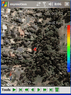
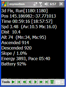
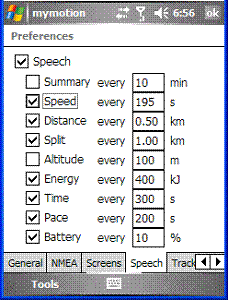
MyMotion - GPS route recording and playback with customizable spoken feedback of speed, distance and time. Uses a moving map to show progress as well as textual output. Maps can be generated from Google Earth installed on a PC using a map creation tool. Allows user to record a route then load it up as a reference for live comparison the next time it is traversed. Optional location tracking of GPS devices with GPRS or 3G, via the web and Google Earth or Google Maps.
· This software is free for personal use.
What's New in This Release:
· Performance Improvements, particularly UI responsiveness.
· User definable default file name format for track save.
· Add sensitivity enabling for menu items.
· Bug fixes: Fixed arrow direction. Fixed corruption with long (> 32 chars) file names in track files.
Like it? Share with your friends!
If you got an error while installing Themes, Software or Games, please, read FAQ.
Supported operating systems:
Windows Mobile 2003, Windows Mobile 5.0, Windows Mobile 6 Classic, Windows Mobile 6 Professional, Windows Mobile 6.1 Classic, Windows Mobile 6.1 Professional, Windows Mobile 6.5 Professional
Similar Software:
OS GPS Convertor OS GPS Convertor converts positions between WGS84 latitude & longitude and Ordnance Survey (OS) British & Irish or Universal Transverse Mercator (UTM) worldwide grid references. It displays positions in multiple formats.
It can be used with:
* TomTom Navigator - to create a Point of Interest (POI) or Itinerary file ... then show on map, navigate to, etc
DocumentGPSed DocumentGPSed - DocumentGPSed allows you to create and view Pocket Word files based on your GPS. When you create a new Pocket Word file then the GPS location is appended to the end of the file. You can explore the Word files via distance of your current GPS.
This program requires that you have both the 'BeanDLL
StoreGoogler StoreGoogler uses the GPS on your PocketPC to find the 50 closest local business from 2,238 type of Yellow Pages entry sorted via GPS distance. Tap the button to start the GPS and when you get a lock tap on it to view the list of local businesses. The GPS maps and business search service is provided by Google
FON Access Points for Argentina FON Access Points for Argentina - FON offers you a new Points of Interest service (POIs). This allows you to download FONspots directly to your navigation device.
What does that mean? You can download a Points of Interest file directly to your navigation device
CyberTracker 3 CyberTracker 3 - Capture data in the field using our unique icon-based user interface and a GPS for georeferencing. Analysis of the results can be done either in CyberTracker or exported to a third party program. Requires PocketPC 2002/2003/WM5+ or Palm 3 and higher
OakLogMobile OakLogMobile - Logger application for your Windows Mobile device. Records GPS and sensor information on your phone.
The log files (*.olg) can later be loaded into TrackView.NET and viewed in all their 3D-glory.
Just copy the .exe-file onto your device manually and run it via the file explorer.
· Logs GPS position, altitude, speed, etc
TaxiAddresser TaxiAddresser uses the GPS on your PocketPC to find your current latitude/ longitude/ speed/ altitude and Googles the Address/City and allows you to send it to a preset Taxi or shuttle service via email. Tap the button to get the GPS lock and when the program gets the lock it will send the email
GPSLockerer GPSLockerer keeps your GPS in your device active. When you tap the button the program will start the GPS and download the GPS data for your area. The program keeps the GPS active to allow for quicker fixes when you use another GPS program
MapSpeedometers MapSpeedometers - MapSpeedometers uses the GPS on your PocketPC to measure your speed in and says it in a computerized voice at an interval that you select. You can select Miles/Km/h and Nautical Miles and the program will repeat the speed-reading at the selected interval.
This program requires that you have both the 'BeanDLL
gpsVP gpsVP - GPS navigation software for Windows Mobile devices. It shows vector and raster maps, records and shows tracks, shows multiple navigation parameters, manages and shows waypoints. It aims to be as usable as possible
Other Software by developer «Ian Pendlebury»:
not found
Comments on MyMotion:
Comments not found
If you noted an error or download link is broken, please, report it via this page or use comments.
MyMotion is compatible with your device Airis T482 (SIM N3)
")