World Atlas by National Geographic - Designed specifically for the iPhone and iPod touch, National Geographic's new and improved World Atlas puts our best maps in the palm of your hand.
The Best Maps
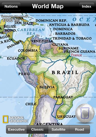
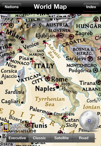
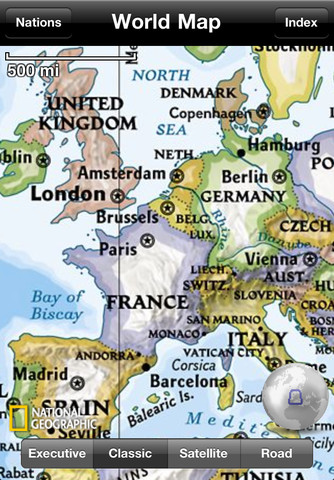
Unlike other map applications, the National Geographic World Atlas utilizes our highest resolution, press-ready images, providing you the same rich detail, accuracy, and artistic beauty found in our award-winning wall maps and bound atlases. The app is preloaded with 3 different styles of world maps, down to country-level detail. With an internet connection, you can continue zooming through continent-level maps into detailed Microsoft Bing maps - close enough to see your home!
Browse the world as you once did in your classroom with the new interactive 3D globe. Spin, pan, rotate and switch between three different map styles including our classic (blue-ocean), executive (antique-inspired) and satellite image.
World Flags and Facts
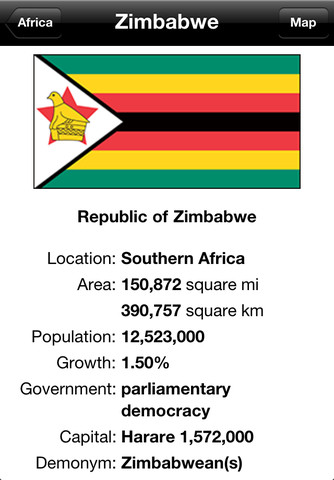
Learn more about the world around you using the up-to-date, expertly researched Flags and Facts database which contains concise geographic and socio-economic data plus recent updates to places like Southern Sudan.
The new touch-and-hold feature makes learning about the World's nations and territories easier. Simply touch-and-hold a place on the 3D globe or any map to pop-up the location's flag-and-fact page.
Search and Bookmark
Bookmark your favorite places with push pins and notes. Center the map to your current position. Find places by name using the built-in index of major world cities or the full online search of nearly 7 million places.
What's New in This Release:
· Addressed a few minor bug reports
Like it? Share with your friends!
If you got an error while installing Themes, Software or Games, please, read FAQ.
Supported operating systems:
Apple iOS 10.x (iPad), Apple iOS 10.x (iPhone), Apple iOS 11.x (iPad), Apple iOS 12.x (iPad), Apple iOS 12.x (iPhone), Apple iOS 4.0.x (iPhone), Apple iOS 4.0.x (iPod Touch), Apple iOS 4.2.x (iPad), Apple iOS 4.2.x (iPhone), Apple iOS 4.2.x (iPod Touch), Apple iOS 4.3.x (iPad), Apple iOS 4.3.x (iPhone), Apple iOS 4.3.x (iPod Touch), Apple iOS 5.0 (iPad), Apple iOS 5.0 (iPhone), Apple iOS 5.0 (iPod Touch), Apple iOS 6.0 (iPad), Apple iOS 6.0 (iPhone), Apple iOS 6.0 (iPod Touch), Apple iOS 7.0 (iPad), Apple iOS 7.0 (iPhone), Apple iOS 7.0 (iPod Touch), Apple iOS 8.x (iPad), Apple iOS 8.x (iPhone), Apple iOS 8.x (iPod Touch), Apple iOS 9.x (iPad), Apple iOS 9.x (iPhone), Apple iOS 9.x (iPod Touch), Apple iPhone OS 3.1.x, Apple iPhone OS 3.1.x (iPod Touch), Apple iPhone OS 3.2.x (iPad)
Similar Software:
Baton Rouge Maps Offline Baton Rouge Maps Offline - This will be perfect when you are traveling and you don't have internet connection. This Offline Maps is not a replacement of Google Maps. It is used when you don't have internet connection and want to use maps
Marrakech Walking Tours and Map Marrakech Walking Tours and Map - No need to hop on a tour bus or join a group; now you can explore all the best attractions on your own, at your own pace, and at a cost that is only a fraction of what you would normally pay for a guided tour
Aix-en-Provence Street Map Aix-en-Provence Street Map - Lets you find all streets, and many useful locations such as ATM's, parkings, museums, and many others. Remembers where you've been so you can find that parking spot where you left your rental car
Seattle Walking Tours and Map Seattle Walking Tours and Map - No need to hop on a tour bus or join a group; now you can explore all the best attractions on your own, at your own pace, and at a cost that is only a fraction of what you would normally pay for a guided tour
Singapore Offline Street Map Singapore Offline Street Map - You don't need to have internet connection for this to work as the map is stored on your iPhone or iPod Touch. Ideal for saving roaming charges or having to find the local wifi to access the built-in map application.
What's New in This Release:
· iOS 5 compatibility changes.
· Further bug fixes and improvements
Dallas Maps - Download DART Train Maps and Tourist Guides Dallas Maps this super-handy app lets you download publicly available maps and store them on your iPhone or iPod Touch. You can download the maps when you have fast wifi connection - and then use any time in the future without delay. DART Train and Street maps, as well as tourist guides to help you around the city
Munich Travel Guide by Triposo Munich Travel Guide by Triposo - Free interactive travel guide to Munich. Works offline and has a detailed map.
About our guide
We make great, interactive travel guides.
To make our guides we use the content that is freely available. Open content sites like Wikitravel, Wikipedia, World66 and Openstreetmap are among the best resources for any traveler
Leiden Street Map Lite Leiden Street Map Lite - Lets you find all streets, and many useful locations such as ATM's, parkings, museums, and many others. Remembers where you've been so you can find that parking spot where you left your rental car
Oslo Walking Tours and Map Oslo Walking Tours and Map - No need to hop on a tour bus or join a group; now you can explore all the best attractions on your own, at your own pace, and at a cost that is only a fraction of what you would normally pay for a guided tour
Bruges Map Offline Bruges Map Offline - This will be perfect when you are traveling and you don't have internet connection. This Offline Maps is not a replacement of Google Maps. It is used when you don't have internet connection and want to use maps
Other Software by developer «National Geographic Society»:
Ultimate Dinopedia: The Most Complete Dinosaur Reference Ever Ultimate Dinopedia: The Most Complete Dinosaur Reference Ever - Based on the award-winning NATIONAL GEOGRAPHIC KIDS ULTIMATE DINOPEDIA: The Most Complete Dinosaur Reference Ever, this app goes beyond any dinosaur encyclopedia you have ever seen
National Geographic Kids National Geographic Kids - Subscriptions to National Geographic Kids magazine are now available! Download the application and you'll receive a free sample.
National Geographic Kids on iPad showcases each issue with engaging interactive content and dynamic functionality. You’ll get amazing facts, photos, and fun
50 Greatest Photographs of National Geographic 50 Greatest Photographs of National Geographic - National Geographic Magazine has searched its vast archives to find its most memorable photographs. This application brings National Geographic's 50 Greatest Photographs to life with the rich features and functionality of iPad
National Geographic's Handheld Birds National Geographic's Handheld Birds - Based on the best-selling book, National Geographic Field Guide to the Birds of North America, National Geographic Handheld Birds is a breakthrough in birding. It was the first North American multimedia software program to empower birders of all levels with easy-to-use interactive referencing capabilities
50 Places of a Lifetime 50 Places of a Lifetime - Make your bucket list with an application from the world's most widely read travel magazine. Inspiring and authoritative, 50 Places of a Lifetime showcases the world's greatest destinations, chosen by National Geographic's family of globe-trotting contributors
7 Billion 7 Billion - National Geographic magazine presents 7 Billion: How your world will change - to coincide with the arrival of the 7 billionth human being to our world. This application explores the challenges of a growing human population in a world of limited resources with informative videos, interactive maps, in-depth articles, and stunning photography
World Atlas HD World Atlas HD - Designed specifically for the iPad, National Geographic's new and improved World Atlas HD puts our best maps in the palm of your hand
GeoBee Challenge by National Geographic GeoBee Challenge by National Geographic - Now with beautiful maps from National Geographic, explore the world while testing your smarts.
This is a challenging game, so it's not for beginners...but do keep in mind that the National Geographic Bee is meant for kids in grades 4-8.
Three types of game play make sure you really know your stuff and never get bored
National Park Maps HD National Park Maps HD - Explore 15 of the top US National Parks with the best collection of trail maps available. National Geographic - THE place for maps - has opened up their best-selling, detailed Trails Illustrated National Parks Maps for download to your favorite Apple device. Plan your trip by browsing the maps and marking places you'd like to see