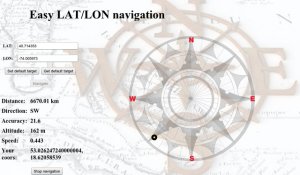
Easy LAT-LON Navigation - navigate You directly to given latitude and longiude, and give You information about: distance from Your position, direction of Your course, accurancy, altitude, speed and coords of Your position
Like it? Share with your friends!
Supported operating systems:
RIM BlackBerry OS 4.6, RIM BlackBerry OS 4.7, RIM BlackBerry OS 5.0, RIM BlackBerry OS 6.0
Similar Software:
Pitch Gauge Pitch Gauge - **How steep is this roof?
**How many squares do I need here?
Always carry your Pitch Gauge with you.
Pitch Gauge not only gets you the pitch of a roof, but also, easily calculate the amount of squares needed to replace a roof.
"Square Calculators" has been around for decades. They are usually made of vinyl or cardboard
Quick Dash Light Quick Dash Light is an informational dashboard designed to be used when travelling. This first version is intended to be used in a car, but future versions might include biking or walking usage scenarios
Compass Lite Compass Lite - This wonderful 'Ancient Mariner' compass uses the built-in GPS in the device to show your line of travel, speed, latitude and longitude and where North is in relation to your heading. To establish a line of travel, you must be moving.
This is the companion program to our more fully-featured Compass application
GPSCalc Simply calculate the distance between points on earth. Compare the distance over the surface with the distance via the rhumb line (includes rhumb bearing too)
AutRun Which way is faster? Whether you are doing your daily commute, visiting friends out of town or running errands on the weekend, the last thing you want to do is waste your time in traffic. With Autrun, you can settle the debate once and for all
Speedometer Odometer Speedometer Odometer - SpeedoMeter is a "must have” App for every cycling, walking, biking or driving enthusiast.
SpeedoMeter is both a speedometer and odometer that provides speed and distance readings whether you are walking, riding a bicycle or driving a car. You can monitor your speed, distance traveled and elapsed time
aiSpot (for touch screen) aiSpot (for touch screen) is a professional application that greatly expands your mobile phone’'s GPS capabilities. Once turned on, aiSpot constantly monitors the available GPS Satellites and updates 13 essential parameters of your trip
Locify With Locify you can explore interesting places near you from Wikipedia, seek for geocaches, display map where you are (or you want to go), twitter your location, save interesting places from phone or web sync them and even navigate to them... and much more.
Locify is free application for common mobile phone
SpeedLimit SpeedLimit-this application was developed in cooperation with wikispeedia.org and is designed to allow you to quickly and easily add speed limit data to their database while you are passing a speed limit sign (Please do not use while driving, make sure you are a passenger in the car)
SpotBerry SpotBerry is a GPS navigation utility for Blackberry devices. With SpotBerry you will be able save your current position and find your way back later, using pretty nice animated SpotBerry compass that shows distance and direction to target. SpotBerry's directional compass also displays your current coordinates, course, speed and azimuth
Other Software by developer «Marina Zielinska»:
not found
Comments on Easy LAT-LON Navigation:
Comments not found
If you noted an error or download link is broken, please, report it via this page or use comments.
Please, select device to check if Easy LAT-LON Navigation supports it


")


