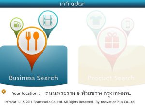
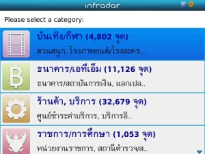
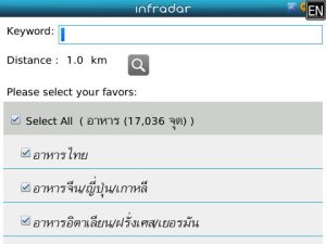
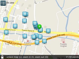
Infradar - Infradar (Information + Radar) is a mobile app, in which Online Map and User’s Lifestyle are blended together in one single app. By using Infradar, your mobile phone is no longer just a phone. It will be transformed to an information hub for Business Search, Product Search, Promotion/Discount Search, and Point Of Interest Search (ShowPoint). You can also choose to display your search results in Map Mode or List Mode. Wanna share your interesting places with others? No problem. You can use our ShowPoint to create and share your cool spots to just only your friends, or to the public.
Like it? Share with your friends!
Supported operating systems:
RIM BlackBerry OS 4.6, RIM BlackBerry OS 4.7, RIM BlackBerry OS 5.0, RIM BlackBerry OS 6.0
Similar Software:
Best Route Enter a starting location and multiple places into the app and select your method of transportation: by car or walking. A route is calculated for you and displayed on the built-in Google Map, showing you the best way to get to all those places
World Wonders Free (BlackBerry) World Wonders Free (BlackBerry) - Finally, in one list, the world's "top" everything:
· The world's fastest...
· The world's tallest...
· The world's most expensive...
· The world's longest..
PLUS MAP PLUS MAP - Plus Map is an application which helps users in viewing the maps from North to South Highways. Other
than that, it allows users to view other services or facilities along the expressway such as the Toll Plaza, Rest Service Area (RSA), Lay by Auto Teller Machine (ATM) and Petrol Station
Mundo Terpel Move around Colombia with this application
PaginasAmarillas PaginasAmarillas - PaginasAmarillas.com
BlackBerry® PlayBookTM app to find information of commercial establishments listed in Páginas Amarillas of Publicar S.A.
Use PáginasAmarillas.com to find restaurants, pubs, Hotels, Banks, public services, and sites of interest close to you
MetrO MetrO is your free guide to public transport systems worldwide (about 400 cities covered now).
· Fully assisted station search (various lists selection or text entry options)
· Station list for each line
· Recently used stations history
· Operating hours management (in selected cities)
· Places of interest: tourism, night life, ..
aiSpot aiSpot is a professional application that greatly expands your mobile phone’'s GPS capabilities. Once turned on, aiSpot constantly monitors the available GPS Satellites and updates 13 essential parameters of your trip
Gps Ski Maps : Chile - Argentina Ski App - for 2011 ski season Gps Ski Maps for ALL Chile/Argentina Skiing / Snowboarding resortsSkiing Resort list at the end.The maps subscription is for 2011 ski season- Instantaneous/Live Trail by Trail analysis right on your phone - only app to do this on BlackBerry®
GPSed Pro GPSed Pro- is a service for trip tracking from mobile. In real time tracks are traced on Google maps and stored in an online archive. With a simple geotagging feature it is possible to pin photos to a map precisely at a place they were taken
대전지하철 대전지하철 - This is a simple version of viewing subway maps of Daejeon in Korea.
It will be kept updating more functionalities such as route finder, time table and other subway maps
Other Software by developer «Innovation Plus Co., Ltd.»:
not found
Comments on Infradar:
Comments not found
If you noted an error or download link is broken, please, report it via this page or use comments.
Please, select device to check if Infradar supports it


")


