MetrO is your free guide to public transport systems worldwide (about 400 cities covered now).
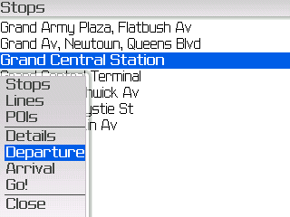
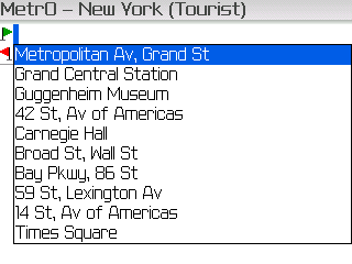
· Fully assisted station search (various lists selection or text entry options)
· Station list for each line
· Recently used stations history
· Operating hours management (in selected cities)
· Places of interest: tourism, night life, ... and detailed information (in selected cities)
· Line deactivation option (in case of strikes or works)
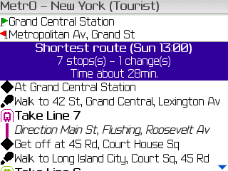
· Line colors in the stop list and in the calculation results
· Contacts list interface (enter your contact's subway stations only once)
· Install only the cities you need (and save memory)
· Extension card compatibility
· City databases exchange through IR interface
· Two different routes suggested (fastest and least connections)
· More than 400 cities included, most of them with complete information, including suburban systems, buses, trams, ferries...
· Frequent updates (every month) for up-to-date information
What's New in This Release:
· New cities: Argenteuil (France), Bagnolet (France), Chengdu (China)
· Major city changes: Amiens, Bogotá, Bratislava, Brisbane, Budapest, Lille, Marseille, Nantes, Quimper, Strasbourg, Toulon
· Other changes: Bangkok, Barcelona, Delhi, Den Haag, Dubai, Dublin, Guangzhou, Košice, Le Mans, Leipzig, London, Lyon, Madrid, Manchester, Miercurea Ciuc / Csikszereda, Moscow, New York, Novosibirsk, Osaka, Paris, Prague, Rotterdam, San Francisco, São Paulo, Shenyang, Tehran, Toulouse, Tours, Vienna
· Minor improvements
Like it? Share with your friends!
Supported operating systems:
RIM BlackBerry OS 4.0, RIM BlackBerry OS 4.1, RIM BlackBerry OS 4.2, RIM BlackBerry OS 4.3, RIM BlackBerry OS 4.5, RIM BlackBerry OS 4.6, RIM BlackBerry OS 4.7, RIM BlackBerry OS 5.0, RIM BlackBerry OS 6.0
Similar Software:
aiSpot (for touch screen) aiSpot (for touch screen) is a professional application that greatly expands your mobile phone’'s GPS capabilities. Once turned on, aiSpot constantly monitors the available GPS Satellites and updates 13 essential parameters of your trip
HelloWorld Map Browser HelloWorld Map Browser - HelloWorld Browser let's you browse Google Maps on your handheld. You can search for a location, search for directions, find a business and view satellite imagery. An essential tool for the professional on the go. Never be lost again!
You can trial HelloWorld for free, so please try before you buy.
Visit www
WorldMate Live Gold Annual Subscription WorldMate Live Gold Annual Subscription-Keep a personal travel assistant in your pocket! WorldMate Live will manage your full itinerary, including travel arrangements and business meetings, making all details immediately accessible on your mobile device, and ensure a smooth trip by pushing alerts regarding imminent events like flight delays
Nutiteq Maps Nutiteq Mobile Mapping SDK demonstration application. It enables to view different map sources, including online (OpenStreetMap) and offline sources produced by TileMill (in MBTiles format) or Mobile Atlas Creator. Also online route finding is possible
Mappy - Maps & Local serach: Simplify your life with maps and local search, you'll discorver what's around you
- Directions: Plan your route from your position or by entering addresses directly by car, pedestrian, bike or public transit
TopoExplorer for Touch Screen Devices ONLY TopoExplorer for Touch Screen Devices ONLY
Features | Free Download
With TopoExplorer you will discover your surroundings on topographic maps even in remote areas assisted by GPS and without the need of the wireless network connection
부산지하철 부산지하철 - This is a simple version of viewing subway maps of Seoul in Korea.
It will be kept updating more functionalities such as route finder, time table and other subway maps
GEOrendr GEOrendr is a great way to discover and use maps. Maps come to life in GEOrendr. Tap on the map or use your current location and discover information about what you see. Find community hosted maps from ArcGIS Online - ESRI’s online GIS. Alternatively you can use the authoring tools on ArcGIS.com to create your own maps that can be used in GEOrendr
NavFunPro NavFunPro is the most universal Google-Maps tool that gives you all the goodies of Google Maps and Google Earth. You can connect your Bluetooth GPS or use the mobile's built in GPS. Then NavFunPro turns your mobile into an all-terrain navigation/gps tool. All your tracks are uploaded to internet. You can check them out at www.trackthisout.com/tm
Wayfaring Wayfaring brings the world in your hands! Wayfaring is an application that makes you a globetrotter while sitting in the comfort of your couch. Wayfaring is for those who love traveling but are not able to go to places they long for
Other Software by developer «P. Bernard & F. Van Caenegem»:
MetrO (Windows Mobile) Metro finds your way in public transport systems in more than 350 cities around the world (Paris, New York, London, Tokyo, any city with a subway & many more!).
FREE, FAST & ACCURATE
MetrO (S60 5th Edition, Symbian^3) MetrO (S60 5th Edition, Symbian^3) finds your way in public transport systems in more than 350 cities around the world (Paris, New York, London, Tokyo, any city with a subway & many more!)
MetrO for Palm OS MetrO for Palm OS - Metro helps you find your way in the public transport systems (subway, bus, trams, ...) in more than 300 cities around the world. FREE, FAST & ACCURATE. Simply enter your start and end stops, hit the "Go" button and the program finds the fastest route
MetrO (BlackBerry) Métro is your free guide to public transport systems worldwide (about 400 cities covered now)


")


")

")