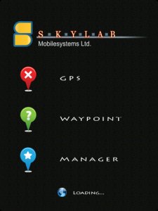
GPS Waypoint Manager - Free BETA - The GPS Waypoint Manager for BlackBerry® Smartphones is a comprehensive tool for managing waypoints and points of interests (POI) right on your phone. By using the GPS in your device, your can accurately pin-point your location and map out other points as well. You also have the ability to import/export .kmz and .kml files with GPS Waypoint Manager.
Important Note: This an early beta version. It might have some bugs, please report them back to us along with improvement suggestions. Thank you.
Features:
- Start / Stop / Auto-start GPS
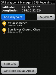
- Show latitude / longitude
- Adjustable units for latitude / longitude, also adjustable units for distance (Imperial / Metric)
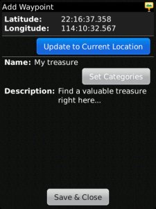
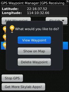
- Add / Edit / Delete waypoint
- Save waypoints to a .kmz/.kml files and view them on Google Earth or GPSVisualizer.com
- Import a .kmz/.kml files with waypoints to view them on GPS Waypoint Manager
- Create a waypoint from current location with a name and description
- Waypoint categorization
- List existing waypoints
- Show distance of waypoint to current / last known location
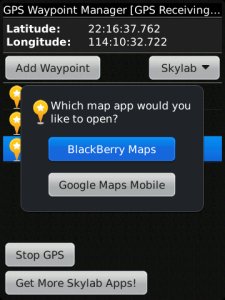
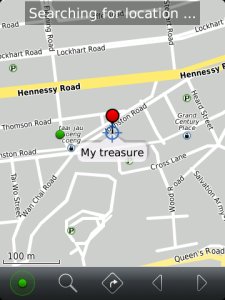
- Show individual waypoint on BlackBerry Maps and Google Maps Mobile
Usage Instructions:
1) Install the application on your device.
2) Click the GPS Waypoint Manager icon to start the application.
3) Move away from tall buildings, outside to an open area to have the best possible GPS satellite coverage.
4) Click "Start GPS". "GPS Searching…" will appear in the program title to indicate GPS is turned on. If you never used your GPS receiver before or it is a long time ago since you used it, it might take up to 30 minutes to obtain the first GPS position fix.
5) Wait until "GPS Receiving…" appears in the title. This means your device has obtained a GPS position fix.
6) Click "Add New Waypoint" to add a new waypoint to your waypoint database.
Requirements:
BlackBerry® Smartphone with internal or external Bluetooth® GPS receiver. If you are unsure, please check with your provider whether GPS is supported on your device.
Note:
GPS Waypoint Manager works best outside in an open area with a clear view to the sky.
Like it? Share with your friends!
Supported operating systems:
RIM BlackBerry OS 4.1, RIM BlackBerry OS 4.2, RIM BlackBerry OS 4.3, RIM BlackBerry OS 4.5, RIM BlackBerry OS 4.6, RIM BlackBerry OS 4.7, RIM BlackBerry OS 5.0, RIM BlackBerry OS 6.0, RIM BlackBerry OS 7.0
Similar Software:
Real Contact Real Contact - Now you can enable your phone to be in RealContact with your BBM friends.
Just set the privacy settings on the app to share your location, availability, battery level and signal level with each BBM Contact.
Never lose your pal again on a concert or split up in a mall. Get together again just by checking your phone screen
AreaCode411 AreaCode411 - Area Code Lookup.
Enter an area code to find out its location and current time.
An indispensable tool - you won't know how you did without it.
Try it for FREE for 4 days before you Buy. Upgrades are FREE.
Visit www.shrunkenhead.biz/areacode411.html for more information
iTrackMe (BlackBerry) iTrackMe (BlackBerry) is a Family GPS Tracker that allows parents to track loved ones using their phones. iTrackMe consists of a web portal (iTrackMe.net) that allows parents to see the location of their kids in real-time on a map and a small mobile application running on the kids' mobile phones. Parents can define safety zones (school, mall, etc
FON Access Points for Cyprus FON Access Points for Cyprus - FON offers you a new Points of Interest service (POIs). This allows you to download FONspots directly to your navigation device.
What does that mean? You can download a Points of Interest file directly to your navigation device
GOTS Tracking Agent GOTS Tracking Agent - The GOTS Tracking Agent turns your BlackBerry® into a tracking device. All Positions are stored on a central server that you can access with your personal login. In your web browser you can easily display the current position or trip histories. The BlackBerry® will also display your surroundings as a map
SimpleTrax SimpleTrax - You aren't sure where your teenager is and she can't hear the phone ringing...how will you find her?
You've just misplaced your phone...
FON Access Points for Argentina FON Access Points for Argentina - FON offers you a new Points of Interest service (POIs). This allows you to download FONspots directly to your navigation device.
What does that mean? You can download a Points of Interest file directly to your navigation device
Btracking Turn your Handset into a GPS Tracker. BerryTracking is a simple API with powerful productivity features. A mobile management system that is based on GPS enabled Blackberry handsets for business or for personal use
ViewRanger Outdoors GPS ★★ with Global Open Sourced Maps★★
ViewRanger turns your Playbook into a fully featured Outdoors Navigation and Location Sharing device. Ideal for Hikers, Mountain Bikers and virtually any Off-Road activity
Other Software by developer «Skylab Mobilesystems Ltd.»:
ContactMapper Geocodes your contacts from the address book and shows them on a satellite or topographic map. The 2-click-on-map-application!
Spot for BlackBerry Spot combines your BlackBerry and Bluetooth GPS receiver into the most powerful positioning tool
Spot Spot - Geocaching, hiking, biking, outdoor activities. Combine the power of GPS with worldwide maps and a flexible waypoint management. Orientation and routing enables you to find interesting places, store and share them with others
LocalWeather LocalWeather is an application for Windows Mobile Smartphones and PocketPCs providing location-based weather information. It retrieves the current location from a GPS receiver, looks up the nearest weather station and fetches information on the current weather conditions from the Internet
MobileTracker MobileTracker
The tracklog application for mobile devices!
Records a tracklog.
Elevation can be tracked.
Configurable timespan between positions.
Extensive statistical information
Spot for BlackBerry (OS 4.2) Spot combines your BlackBerry and Bluetooth GPS receiver into the most powerful positioning tool
GPS SightFinder GPS SightFinder looks for sights, landmarks and other interesting places close to your current location. Descriptive search results with thumbnail images link to the corresponding Wikipedia articles for detailed up-to-date information.
GPS SightFinder is a Windows Mobile application for Smartphones and PocketPCs with built-in GPS or a connected Bluetooth GPS device
TopoExplorer for Non-Touch Screen Devices ONLY TopoExplorer for Non-Touch Screen Devices ONLY
Features | Free Download
With TopoExplorer you will discover your surroundings on topographic maps even in remote areas assisted by GPS and without the need of the wireless network connection
TopoExplorer for Touch Screen Devices ONLY TopoExplorer for Touch Screen Devices ONLY
Features | Free Download
With TopoExplorer you will discover your surroundings on topographic maps even in remote areas assisted by GPS and without the need of the wireless network connection


")

")


")


