ViewRanger Outdoors GPS - ★★ with Global Open Sourced Maps★★
ViewRanger turns your Playbook into a fully featured Outdoors Navigation and Location Sharing device. Ideal for Hikers, Mountain Bikers and virtually any Off-Road activity.
ViewRanger lets you plan, plot, navigate, track, locate, record, analyse & share your outdoor adventures on a range of global web map layers like OpenStreetMap & OpenCycleMap.
In USA, Canada, UK, NZ and many other countries, it’s easy to upgrade to run premium topographic maps. (See our website to find out more).
The App comes with a free to join online outdoors community** - my.viewranger.com, which can be “sync'd” to your device. Create your own routes or utilize those posted by experts or the community. Upload your adventures and attach geotagged photo’s from Flickr or Picasa - ready to be stored, published to the community or shared via Facebook.
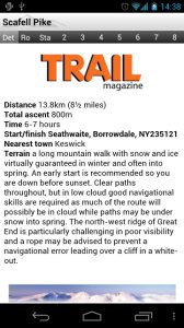
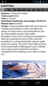
★★★★★ "Innovative software that transforms your phone or tablet." Trail
Magazine
★★★★★ Sunday Times “must have” app
★★★★★ Featured on Channel 5 Gadget Show
Used and trusted by search and rescue teams.
_______________________________________
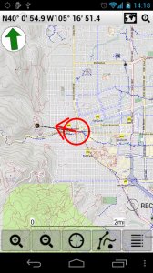
MAPS FOR ALL TERRAINS
✔Street and other mapping – choose between street, cycling and aerial imagery (global coverage)
✔Upgrade to full topo mapping in many countries
✔Works even without mobile coverage - as maps can be stored on your playbook(off-line)
✔Maps can be downloaded on the move**
✔Easy to read with Head-up and North-up view options.
_______________________________________
RECORD YOUR TRIPS
✔Clearly mark the path you've taken on the map in real-time.
✔Save the recorded path of all your trips
✔Upload your adventures to our online tool to share using Facebook or publish to the community
✔Create trip journals with photos from your Flickr™ or Picas*accounts
_______________________________________
ALL THE STATS YOU NEED
✔Real-time sport computer stats for over 30 metrics (i.e. speed, distance, time, elevation, pace, ETA, etc)
✔customise screen views in text, dial or graphical format
✔Real-time on-screen map co-ord display (UTM WGS84, NAD27, ITM, Lon/Lat, etc)
✔Supports imperial, nautical and metric units
_______________________________________
EASY TRIP PLANNING USING APP OR WEB
✔Download an expert guided route**
✔Create your own routes using the in-app tool or our online planner
✔Import a route as a GPX file
_______________________________________
FULL ON-SCREEN NAVIGATION
✔Active waypoint-based Navigation with on-screen visual guidance
✔Navigation alarms if you veer too far off track
______________________________________
LOCATION SHARING**
✔Share your real-time location with BuddyBeacon™ (a feature from ViewRanger)
✔See the mapped location of your friends on screen
✔Link your Twitter™ messages, photos and videos
_______________________________________
SEARCH & LOCATE
✔Search by Place name using online services.
✔Find location using map coordinate entry (ideal for Geocaching)
✔Real-time on-screen map coordinate display
✔Mark any important location as a Point of Interest (PoI)
Need more info: see our website: www.viewranger.com. Any questions or feedback, please drop us an e-mail: support@viewranger.com
Notes: * registration required, **may incur additional charges ***requires mobile data
Like it? Share with your friends!
Supported operating systems:
RIM BlackBerry PlayBook OS 2.0, RIM BlackBerry Tablet OS 1.0
Similar Software:
GPS Golf Range Finder GPS Golf Range Finder from Swing by Swing is a full-featured GPS range finder that shows distance to green, and any obstacle on the course.
OVER 1,000 COURSES HAVE BEEN ADDED IN THE LAST MONTH! If your course is not yet live in the system, you can easily add it right from our website
FON Access Points for Pakistan FON Access Points for Pakistan - FON offers you a new Points of Interest service (POIs). This allows you to download FONspots directly to your navigation device.
What does that mean? You can download a Points of Interest file directly to your navigation device
TrackMyJourney (BlackBerry) TrackMyJourney (BlackBerry) is a mobile application that uses GPS data to provide a number of functions, including navigation, location tracking, map display and route plotting. It receives its location coordinates by communicating via Bluetooth with a separate GPS receiver, or via the phones internal GPS if supported
Foyage Foyage - Wherever you go, Foyage is your personal radar. !
Works only in Singapore & Indonesia !!!
Features include :
* current position is auto-update and shown in road name
* more than 12,000 location information in Singapore & Indonesia; including petrol kiosk, atm, restaurant, cafe, bakery, fast food, food stall, nursing room, post office, etc
MyLittleGPS MyLittleGPS for GSM Blackberry, is a new way to use your BB in mobility. With this application you can record different special GSM Cell and associate to them particular events
SpotBerry SpotBerry is a GPS navigation utility for Blackberry devices. With SpotBerry you will be able save your current position and find your way back later, using pretty nice animated SpotBerry compass that shows distance and direction to target. SpotBerry's directional compass also displays your current coordinates, course, speed and azimuth
e-Mobile Family Locator e-Mobile Family Locator-
Locate device and people
Locate device and people by sending a "locate" text message
Where 8300 Where 8300 is a mobile GPS application that helps you find the people, places and things that matter the most to you. With a wealth of GPS widgets, WHERE is your first stop when looking for things to do and places to go
Location Diary Location Diary uses GPS to find out where you are, and then saves it in a list of easily readable locations. You can compare where you are with other entries in the diary to see the distance from where you are to each of your diary locations. You can name your locations to quickly recognize entries in your diary
IamHere IamHere is a neat little utility to email your current GPS location to anyone. If you have Google Maps installed you can email your Google Map location!
IamHere can also be used to save your current GPS location to the Calendar application.
You can also use IamHere to capture the current screen and email it or save it to the SD card
Other Software by developer «Augmentra»:
not found
Comments on ViewRanger Outdoors GPS:
Comments not found
If you noted an error or download link is broken, please, report it via this page or use comments.
Please, select device to check if ViewRanger Outdoors GPS supports it


")


