Geo Walk HD - Concise Encyclopedia of Surprising Facts at Hand! Discover the world around you with simple and educational application that collects amazing and fun facts about all the most interesting things of our planet.
Geo Walk is a concise, easy-to-use and information packed encyclopedia for iPhone/iPod Touch that contains only the most interesting and valuable information about our multifaceted world. It suits both adults and children curious about far away places, great people, and the most amazing living creatures. Geo Walk can become a convenient companion for inveterate travelers who are always on the go.
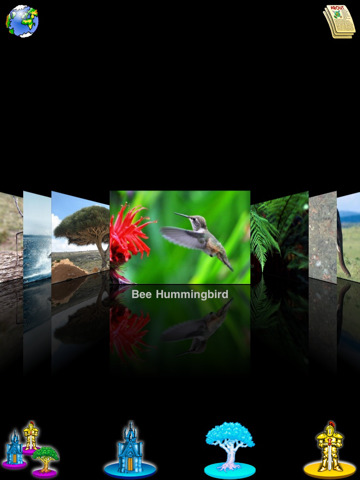
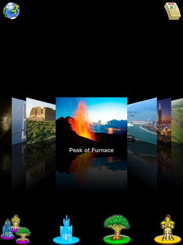
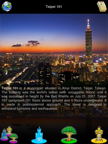
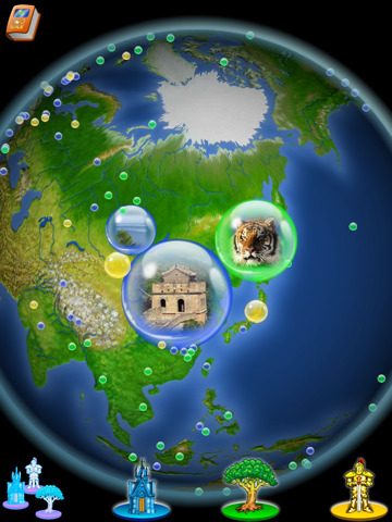
Geo Walk app features only the most amazing and unusual articles that are gathered in one place. Spin the globe to choose the most interesting place and read all there's worth to know about it! The application has 3 main categories to browse through: Places, Flora and Fauna, People. All entries are provided with colorful pictures that can be viewed in a cover-flow or chosen object mode.
· 300 UP-TO-DATE DESCRIPTIONS: Around 300 objects with up-to-date descriptions are available for your edutainment. Learn about interesting places, great people, unusual animals and plants around the world.
· SMOOTH & STYLISH INTERFACE: Intuitive, snazzy interface that allows you to smoothly scroll the photos is a real pleasure to learn from/to use.
· CATEGORY FILTER: With a category filter you can choose the category you are curious about.
· 2 SEARCHING MODES: Tap any icon on the globe to read more info about the subject of interest or use an object list for the same purpose.
· 2 VIEWING MODES: cover-flow or chosen object mode are available so you always have an option.
What's New in This Release:
· support of retina display
· compatible with iPhone 5
· minor bug fixes
What's New in 2.4.1:
· A new Earth texture for a more thorough zoom in
· New cards design and animation
· Connect with us on Twitter and Facebook
· Bug fix
What's New in 2.4:
· In-App purchase store: 3 packs with content from a well-known publisher DK (Animals and Plants, History, People and Inventions)
· New enhanced interface for better navigation
· Search
· New category: Inventions
· Wiki links for all items
· Bug fix
What's New in 2.3:
· More than a hundred of new items and quizzes added
· News layer
· Revamped gestures for easier navigation
· New control panel to read the info, post to FB, Twitter, e-mail and picking the favorite items
· Bug fix
Like it? Share with your friends!
If you got an error while installing Themes, Software or Games, please, read FAQ.
Supported operating systems:
Apple iOS 10.x (iPad), Apple iOS 10.x (iPhone), Apple iOS 11.x (iPad), Apple iOS 12.x (iPad), Apple iOS 12.x (iPhone), Apple iOS 4.0.x (iPhone), Apple iOS 4.2.x (iPad), Apple iOS 4.2.x (iPhone), Apple iOS 4.3.x (iPad), Apple iOS 4.3.x (iPhone), Apple iOS 5.0 (iPad), Apple iOS 5.0 (iPhone), Apple iOS 6.0 (iPad), Apple iOS 6.0 (iPhone), Apple iOS 7.0 (iPad), Apple iOS 7.0 (iPhone), Apple iOS 8.x (iPad), Apple iOS 8.x (iPhone), Apple iOS 9.x (iPad), Apple iOS 9.x (iPhone), Apple iPhone OS 3.1.x, Apple iPhone OS 3.2.x (iPad)
Other Software by developer «VITO Technology»:
Map of West Virginia (US State) Map of West Virginia (US State) - A map of the West Virginia by VITO Technology. Good for intercity travels with SmartMap.
SmartMap is a mobile device application which uses vector and raster maps. It is compatible with any NMEA protocol GPS receiver (Compact Flash socket, serial port, BlueTooth or sleeve)
Map of Philippines Map of Philippines - A map of Philippines. Good for intercity travels with SmartMap.
Layers include:
Towns
Settlements
Airports
Roads
Railroads
Rivers
Inland water
Administrative borders
International borders
Trees
Map scale is 1:1 million.
Good for use with any version of SmartMap
VITO VoiceReminder VITO VoiceReminder -VITO Technology has just launched the VITO Voice Reminder v2.0! This is a talking alarm clock which can also playback your voice messages at the set time. Thanks to the new user interface, you can now create reminders in seconds! VITO Voice Reminder v2
Map of Suriname Map of Suriname - A map of the Suriname by VITO Technology. Good for intercity travels with SmartMap.
SmartMap is a mobile device application which uses vector and raster maps. It is compatible with any NMEA protocol GPS receiver (Compact Flash socket, serial port, BlueTooth or sleeve)
Map of Wisconsis (US State) Map of Wisconsis (US State) - A map of the Wisconsis by VITO Technology. Good for intercity travels with SmartMap.
SmartMap is a mobile device application which uses vector and raster maps. It is compatible with any NMEA protocol GPS receiver (Compact Flash socket, serial port, BlueTooth or sleeve)
Map of Slovenia Map of Slovenia - A map of Slovenia. Good for intercity travels with SmartMap.
Layers include:
Towns
Settlements
Airports
Roads
Railroads
Rivers
Inland water
Administrative borders
International borders
Trees
Map scale is 1:1 million.
Good for use with any version of SmartMap. SmartMap can be purchased here
Map of South Africa Map of South Africa -
A map of South Africa, divided into 9 smaller territories for the ease of use.
NORTHERN
NORTH WEST
GAUTENG
MPUMALANGA
FREE STATE
KWAZULU-NATAL
EASTERN CAPE
NORTHERN CAPE
WESTERN CAPE
Good for intercity travels with SmartMap
Map of Poland Map of Poland - A map of Poland. Good for intercity travels with SmartMap.
Layers include:
Towns
Settlements
Airports
Roads
Railroads
Rivers
Inland water
Administrative borders
International borders
Trees
Map scale is 1:1 million.
Good for use with any version of SmartMap. SmartMap can be purchased here
Winterface Winterface is a mobile shell of next generation that can virtually replace the default Windows Mobile user interface. Winterface also gives users the full freedom of organizing interface exactly as they like it, with style and enhanced functionality


")


")


