ppc FindMyCar - Innovative software for Windows Mobile devices that uses the GPS signal to show signs that allow to reach a geographic location.
Suitable for various uses (eg. find car parked in a parking area or in an unknown city, finding a person (who has sent their coordinates) in a lovely beach, in a fair, in another boat, find an area of sea fishing, etc..).
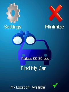
· store position and then retrieved at a later date
· forward our position with sms
· set the position transmitted (eg. the person we are looking for) with the copy-paste function
· displayed on the map (via internet GoogleMap) location to be searched
Like it? Share with your friends!
If you got an error while installing Themes, Software or Games, please, read FAQ.
Supported operating systems:
Windows Mobile 2003, Windows Mobile 5.0, Windows Mobile 6 Classic, Windows Mobile 6 Professional, Windows Mobile 6.1 Classic, Windows Mobile 6.1 Professional, Windows Mobile 6.5 Professional
Similar Software:
FON Access Points for Algeria FON Access Points for Algeria - FON offers you a new Points of Interest service (POIs). This allows you to download FONspots directly to your navigation device.
What does that mean? You can download a Points of Interest file directly to your navigation device
MyGPS_PDA MyGPS_PDA - MyGPS_PDA is a light MyGPS version for PocketPC systems. It reads the NMEA sentences coming from a GPS antenna connected to the PocketPC and shows your position on a MyGPS calibrated map. The program can also store on a file the track log together with specific waypoints created by the user
MapGoogler MapGoogler uses the GPS on your PocketPC to find your current latitude/longitude/speed and altitude and allows you to view your position on a map from the Google.com maps service. You can customize the maps zoom, and type via the 'Options' in the toolbar. The maps service is provided by Google
ContactGPSer ContactGPSer allows you to create and view phone/SMS/email contact number '.cgps' links and Dial/SMS or Email the contacts via GPS distance. Select 'Start GPS' to get a GPS lock and create a new '.pgps' contact link. The program displays the distance between each contact via your current GPS
TaxiAddresser TaxiAddresser uses the GPS on your PocketPC to find your current latitude/ longitude/ speed/ altitude and Googles the Address/City and allows you to send it to a preset Taxi or shuttle service via email. Tap the button to get the GPS lock and when the program gets the lock it will send the email
Location Tracker SDK Location Tracker SDK - Includes client software capable of reading from bluetooth enabled GPS receiver as well as a .NET assembly that will receive lattitude and longitude information wireless for plotting in your mapping solution of choice
FON Access Points for French Guiana FON Access Points for French Guiana - FON offers you a new Points of Interest service (POIs). This allows you to download FONspots directly to your navigation device.
What does that mean? You can download a Points of Interest file directly to your navigation device
Glopus Glopus is a program for the Pocket PC that delivers information from a GPS receiver
BackCountry Navigator BackCountry Navigator is fun-filled navigation software for the outdoor adventurer. Use it in a variety of outdoor adventures, from kayak touring to geocaching. This is a summary of what you can do with the product.
BackCountry uses free topo and aerial maps for the United States, downloaded directly from Terraserver-USA
FON Access Points for Netherlands FON Access Points for Netherlands - FON offers you a new Points of Interest service (POIs). This allows you to download FONspots directly to your navigation device.
What does that mean? You can download a Points of Interest file directly to your navigation device
Other Software by developer «Andrea Pace»:
j2me PhotoGeoTag j2me PhotoGeoTag - Take pictures with your mobile phone and incorporate the data of the geographical location. The application allows you to include in the photographs, data from the GPS receiver, along with a brief note. If you know the coordinates, not having the GPS receiver, you can also handwrite geographic data
Android Photo GeoTag Android Photo GeoTag - Take pictures with your mobile phone and incorporate the data of the geographical location. The application allows you to include in the photographs, data from the GPS receiver, along with a brief note. If you know the coordinates, not having the GPS receiver, you can also handwrite geographic data
PPC PersonalTrainer Calculate calorie needs and kcal, fat, fiber, carbohydrates and proteins recruited. Calculate the optimal body size
PIM remover PIM remover - Application that allows you to delete the information introduced in Windows Mobile devices and Pocket PC maintained by the so-called Personal Information Manager (ie appointments, phone book and tasks).
Useful when you must sell or transfer possession of the phone or when he lost control of archives (eg
J2ME ZipRSS J2ME ZipRSS - Innovative application that allows the reception of RSS feeds at low cost. The operation is as simple as effective.
1. The application connects to the developer's server and asks for the required feed;
2. The server obtains the feed at the site that produces it;
3. The server performs the compression of required feed;
4
J2ME PersonalTrainer Calculate calorie needs and kcal, fat, fiber, carbohydrates and proteins recruited. Calculate the optimal body size
Calcola Taglie (Clothing Size) Calculate - size clothing and accessories. It allows the calculation of certain components of clothing. Easy to use. Fit the size head, life, neck and sides and you get the size calculated. For shoes, just insert the length of the foot longer and you get the size
J2ME phoneAlcolTest phoneAlcolTest is an application which measures the rate of alcohol. The first application, created in Italy, which allows to estimate the blood alcohol content theory using the phone or smartphone.
It calculates the blood alcohol content according to the tables attached to D.M


")
