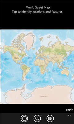
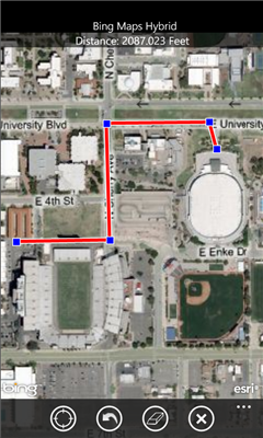
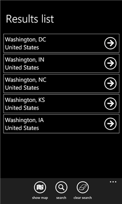
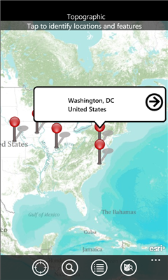
ArcGIS is a great way to discover and use maps. Tap on the map or use your current location to discover information about what you see. Search and find interesting information in the map as well as measure distances and areas. Find community hosted maps from ArcGIS Online, ESRI's online GIS, or use the authoring tools on ArcGIS.com to create your own maps that can be used in ArcGIS. Collect and edit data within a map and share your edits with others.
If you are an existing ESRI customer, this application is part of your ArcGIS system. You can share your corporate maps and extend the reach of your GIS to Windows Phone devices within your enterprise using ArcGIS Server.
Features
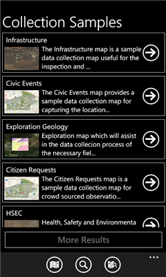
- Use maps authored in ArcGIS.com
- Navigate map galleries
- Access your own GIS data
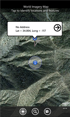
- Display and zoom to current location
- Perform linear and area measurements
- Retrieve detailed map metadata
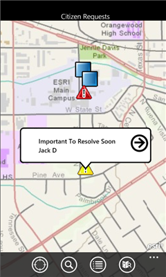
- View feature attribute information
- Perform keyword search and get access to relevant information
- Change the visibility of layers
- Access popular maps faster by adding them to your favorites list
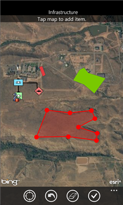
- Use your GPS or tap on the map to collect and update GIS data
- Attach photos to what you collect
Like it? Share with your friends!
If you got an error while installing Themes, Software or Games, please, read FAQ.
Supported operating systems:
Windows 10 Mobile, Windows Phone 7, Windows Phone 8
Similar Software:
Travel Tokyo, Japan - illustrated guide, phrasebook, and maps. FREE general info, maps and more Travel Tokyo, Japan - illustrated guide, phrasebook, and maps. FREE general info, maps and more - An illustrated travel guide, phrasebook, and maps. Indulge Yourself with a personal tour guide on Your PDA. FREE General Information, basic phrasebook, and a map in the trial version.
Features
Fully illustrated.
Historical overviews
MapsGo MapsGo - Simple GIS for Desktop and Pocket PC with export to MapMap for Palm
Gippos See your location on a map and share this information with your friends. See on a map your contact list users who didn't hide their locations and send messages to them
Map of Nevada (US State) Map of Nevada (US State) - A map of the Nevada by VITO Technology. Good for intercity travels with SmartMap.
SmartMap is a mobile device application which uses vector and raster maps. It is compatible with any NMEA protocol GPS receiver (Compact Flash socket, serial port, BlueTooth or sleeve)
Google Navigator Google Navigator is the most powerful and easy to use GPS navigation software on your Pocket PC. Also is the best and most easy to use and convenient software on your Pocket PC. All map data is transferred from Google via network, and save permanently on your device until you want to delete it
Speereo Voice Translator: English-Finnish (WM) Speereo Voice Translator (SVT) is an ideal companion for traveling on business or leisure and also is an excellent aid for business communication. Running on Windows Mobile and Symbian based mobile devices it contains of over 4000 phrases in each of 16+ languages and many other useful features
Canada Topography Canada Topography - provides topographic information for the entire country of Canada. The maps provide details such as altitude, railways and numerous other layers. Using the GPS you can center on your current location and even zoom to specific areas of the country.
All maps are provided by Geocratis Canada (http://www.geogratis.gc.ca/geogratis/en/service/toporama
LiteTrack LiteTrack is the right tool to record your route, save off-road paths, retrace a way, get your position on the map with detailed gps data (satellite charts, speed and much more)


![USA-AZ [Arizona] Map for EagleEye PDA Tracking System](https://static.mobyware.org/data/images/def_program_reduced.png "USA-AZ [Arizona] Map for EagleEye PDA Tracking System")


")

")

