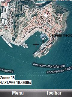
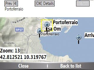
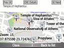
Bluemapia Mobile - View Maps, Search places and geotagged Wikipedia articles, GPS. Mobile Application for bluemapia, the new Web & Mobile Social Mapping for Boaters
- View Maps (OpenStreetMap and other web map servers)
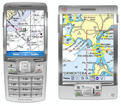
- Support BSB/NOAA Charts and raster, calibrated charts
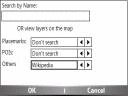
- Search places by name and bluemapia content from the web site
- View geotagged Wikipedia articles on the map
- Use a GPS to display your position on the map and set a terget destination
- Create tracks (gpx file)
- Shoot and upload photos and text to bluemapia for community sharing
Like it? Share with your friends!
If you got an error while installing Themes, Software or Games, please, read FAQ.
Supported operating systems:
Windows Mobile 2003, Windows Mobile 5.0, Windows Mobile 6 Classic, Windows Mobile 6 Professional, Windows Mobile 6.1 Classic, Windows Mobile 6.1 Professional, Windows Mobile 6.5 Professional
Similar Software:
TravelNMEA TravelNMEA - TravelNMEA uses the GPS on your PocketPC to log your latitude/longitude/altitude and speed in a NMEA standard format file. You can also tap on the Google.com button for a road map from the Google.com maps mobile service.
This program requires that you have both the 'BeanDLL.dll' file ** and ** the runtime files for Visual Basic on your PocketPC computer
FON Access Points for South Africa FON Access Points for South Africa - FON offers you a new Points of Interest service (POIs). This allows you to download FONspots directly to your navigation device.
What does that mean? You can download a Points of Interest file directly to your navigation device
GPS2Watch GPS2Watch - Add-on for smartWatchM that displays GPS information on supported Bluetooth watches. It simply uses smartWatchM "3rd party notifications", and connects to WM5+'s intermediate GPS driver, so no messing with COM ports. It should work with any device/GPS combination, if the GPS is external it must be set in WM's "External GPS" settings
CellGPSer CellGPSer uses the cellular signal on your device to instantly find your approximate GPS. Tap the button while your phone is on and the program will send your cellular tower information to OpencCellID.org. The program will then display the approximate GPS. This service is provided by OpenCellID
FON Access Points for French Guiana FON Access Points for French Guiana - FON offers you a new Points of Interest service (POIs). This allows you to download FONspots directly to your navigation device.
What does that mean? You can download a Points of Interest file directly to your navigation device
3D Tracking 3D Tracking is a revolutionary way to use the Internet to either monitor the movements of a live vehicle/person or to display a previous route that's been travelled. The vehicle/person's path is displayed as a line on either Google Earth or Google Maps with details of the speed at each point along the route
BankGoogler BankGoogler uses the GPS on your PocketPC to find the 50 closest banks (ATMs) sorted via GPS distance. Tap the button to start the GPS and when you get a lock tap on it to view the list of local banks. You can also dial the bank. The GPS maps and bank search service is provided by Google
GPS Tuner Essentials Full Version with Nordic Countries Basic Map Content GPS Tuner Essentials Full Version with Nordic Countries Basic Map Content is designed specifically for off-road use: its large buttons, selectable tool window size, multiple Compass views and the built-in Tele Atlas map makes it extremely user-friendly and reliable
QuickGPS Lite QuickGPS Lite can speed up the time for determining your GPS position by downloading the latest satellite data via an Internet connection (such as GPRS, ActiveSync, etc.).
For quickest connection use:
1. Mod Driver
2. QuickGPS Lite
3. GPS Test
It takes around 10 seconds from cold start to get 9 satellites and have a stable connection
FilesGPSed FilesGPSed - FilesGPSed is a file explorer for files that are GPS-tagged. You can view the distance of each file from your current GPS location ascending distance order in real time. The program updates the distance of all files every 5 seconds based on your current GPS location.
This program requires that you have both the 'BeanDLL
Other Software by developer «Bluemapia»:
not found
Comments on Bluemapia Mobile:
Comments not found
If you noted an error or download link is broken, please, report it via this page or use comments.
Please, select device to check if Bluemapia Mobile supports it