En Zaragoza - Localiza cientos de lugares de interes de Zaragoza rapidamente a traves del mapa.
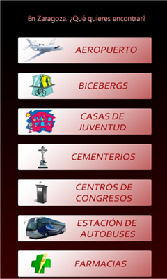
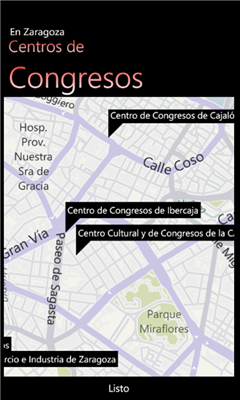
"En Zaragoza" es una aplicacion gratuita que permite localizar, mediante un mapa de la ciudad de Zaragoza, cientos de lugares de interes. Localiza centros de salud, estaciones Bizi, farmacias, parques, etc. en pocos segundos y visualizalos en el mapa para encontrarlos rapidamente.
Like it? Share with your friends!
If you got an error while installing Themes, Software or Games, please, read FAQ.
Supported operating systems:
Windows 10 Mobile, Windows Phone 7, Windows Phone 8
Similar Software:
PDFJPGMaps PDFJPGMaps - PDFJPGMaps allows you to download a Google.com map of your current GPS and convert to PDF file format. You can draw on the map and also insert text into the maps as well as use the drawing tools. The JPEG libraries are from Independent JPEG Group. The map service is provided by Google.com. The PDF libraries are from JPEG2PDF by Hao Hu 2008
Transit Maps USA Free Transit Maps USA Free - The only Transit Maps app of its kind. You can select the city you want to see the transit maps for and zoom in to view the map in detail on the full screen. You can easily zoom-in, pan, and zoom-out using one hand only. You can now plan your trip from anywhere, any time - no Internet/data connection required
Map of Barcelona / Spain for City Advisor Map of Barcelona / Spain for City Advisor.
1. Download the map (zip file)
2. Extract the files in /CityAdvisor/maps
3. Open CityAdvisor -> Maps icon -> Menu -> Refresh
4
Speereo Voice Translator: English-Arabic for WM Non-Touchscreen Speereo Voice Translator (SVT) is an ideal companion for traveling on business or leisure and also is an excellent aid for business communication. Running on Windows Mobile and Symbian based mobile devices it contains of over 4000 phrases in each of 13+ languages and many other useful features
Wayfinder Earth (Pocket PC) Wayfinder Earth (Pocket PC) - The world in your hand! Welcome to the ultimate experience of discovering the earth on your mobile phone, for free…
How does it all work?
It's simple. Wayfinder Earth presents you with a 3D globe representing the planet earth, visible on the display of your mobile phone
Pocket Atlas 2007 Pocket Atlas 2007 - Topographical world atlas with relief elevations, rivers, inland waterways, roads and cities. Oceans with depth contours. Easy to use. Three Zoom steps to show map extracts down to 80 miles across. You can move the maps with a stylus or joystick and measure distances between any two points. Fast display of map extracts
Rough Guides Map Washington DC Rough Guides Map Washington DC... These guides are a series of fantastic interactive maps.
Produced in conjunction with the premier travel publisher Rough Guides.
Discover and explore Washington DC using full colour interactive linked maps, in this simple to use PDA version of The Rough Guides Washington DC
Other Software by developer «nachoMV»:
not found
Comments on En Zaragoza:
Comments not found
If you noted an error or download link is broken, please, report it via this page or use comments.
Please, select device to check if En Zaragoza supports it


![USA-PA [Pennsylvania] Map for EagleEye PDA Tracking System](https://static.mobyware.org/data/images/def_program_reduced.png "USA-PA [Pennsylvania] Map for EagleEye PDA Tracking System")


")


