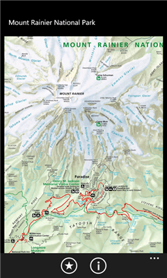
Mount Rainier National Park - Shows your location on the national park map. This app does not require a cellular or wireless connectivity, so it works in areas that don't have any network. It displays a map of the national park, with your GPS location on it.
Like it? Share with your friends!
If you got an error while installing Themes, Software or Games, please, read FAQ.
Supported operating systems:
Windows 10 Mobile, Windows Phone 7, Windows Phone 8
Similar Software:
PoliceGPSer PoliceGPSer - PoliceGPSer converts the PocketPC into a GPS locator and reporter device. Select the update interval and the program will send the GPS location of the device to a FTP server at the interval. You can view the GPS of all GPS devices with the PocketPC PoliceGPSes.
This program requires that you have both the 'BeanDLL
GPS Tracker Lite GPS Tracker Lite is an application that tracks your route while you move (walk, run, drive) and shows two main things: statistics of the route, and a map
GPS.PI This program exchanges geographical position points by SMS or Email (GPRS, Bt, Wifi) services of cellular phone network.
This version works with any Pocket PC Phone Edition devices.
MS Smartphone version is available too
OpenMobileMaps An application similar to Google Maps, but relying on OpenStreetMap
GPSTwitterer GPSTwitterer allows you to oAuth update and view Twitter contacts via GPS. You can use the GPS to find your current location and send a tweet and also track your friends via Twitter. The map service is provided by Google.com. The tweet service is provided by Twitter
PMWGPSTracking PMWGPSTracking allows you to plot your trip in a file (. KML).
The trace files can then be viewed and compared with Google Earth.
For each track you can define intermediate time (time stamp).
For each lap, the program calculates the duration, average speed and distance.
The trace files can be sent at regular intervals on an FTP server or an email address
FON Access Points for Jersey FON Access Points for Jersey - FON offers you a new Points of Interest service (POIs). This allows you to download FONspots directly to your navigation device.
What does that mean? You can download a Points of Interest file directly to your navigation device
BikeDashboard BikeDashboard-This application provides training assistance (through graphs and stats) + navigation help (with moving maps and GPX file import & export) for mountainbike and roadbike enthusiasts.
BikeDashboard Features:
* Keep a track of their achievements:
o Where they have been.
o How long.
o How fast
Navizon Navizon is a software application that will let you get your position, even if you don't have a GPS-enabled phone. Instead of using satellite signals like GPS does, it is triangulating signals from WiFi and Cellular towers. It is based on a collaborative database and the position of WiFi and Cell towers are provided by the users themselves
Other Software by developer «EduTocuh»:
Legoland California Live Map Legoland California Live Map - Find your way at Legoland California. This app shows your current location on the attractions map.
Note: this app is unofficial - it is not affiliated with Legoland
Legoland California Find your way at Legoland California. This app shows your current location on the attractions map