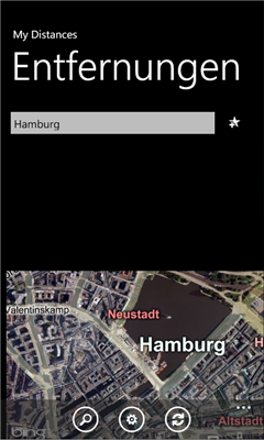
MyDistances - Die App ermoglicht es, die Koordinaten mehrerer Orte zu speichern und die Entfernungen zum aktuellen Standpunkt zu berechnen. Auch Entfernungen von einem der Orte zu allen anderen gespeicherten Orten lassen sich schnell ermitteln. Alle Orte konnen schnell und einfach auf der Karte angezeigt werden.
Like it? Share with your friends!
If you got an error while installing Themes, Software or Games, please, read FAQ.
Supported operating systems:
Windows 10 Mobile, Windows Phone 7, Windows Phone 8
Similar Software:
FON Access Points for South Africa FON Access Points for South Africa - FON offers you a new Points of Interest service (POIs). This allows you to download FONspots directly to your navigation device.
What does that mean? You can download a Points of Interest file directly to your navigation device
AIS2OZI AIS2OZI - AIS2OZI tracks ship positions. It is a logger/decoder/plotter for PocketPC.
Ship positions are plotted directly in OziExplorer Download AIS2OZI (Make backup of Shiplist.txt when reinstalling.)
Decodes AIVDM sentences of types 1, 2, 3 and 5, i.e. position reports for class A shipborne equipment plus vessel information
SupertweetGPS SupertweetGPS - SupertweetGPS allows you to send GPS based tweets to Twitter via SuperTweet.net. When you get a GPS lock enter the text and tap the button to send the Tweet with your current GPS. The program will send the tweet to Twitter.com with your current GPS. NOTE: To use Geolocation on Twitter in 'Settings/Account/Tweet Location' enable
FON Access Points for France FON Access Points for France - FON offers you a new Points of Interest service (POIs). This allows you to download FONspots directly to your navigation device.
What does that mean? You can download a Points of Interest file directly to your navigation device
NoteGPSs NoteGPSs - NoteGPSs can be used to make voice/drawing notes with a GPS tag as the note file name. Each time you make a note the note is named the latitude and longitude of the file. You can store your files on the storage card. You can also view the note entries with Google maps.
This program requires that you have both the 'BeanDLL
Here I am With "Here I am" you can see your friend and your friend can see you on a map or webbrowser, on a pc or on a windows phone 7 device or other. So its easy to meet him on a unknown area (city center or a music festival).
the best of it: Its free
GPS Location GPS Location - This application finds your location via GPS (provided you have a internal or external GPS).
Then you have the option to:
1. Send an SMS
2. Send an Email
3. Create a Note
4. Send to Clipboard
your location as just plain coordinates (40.089821,22.567634) (can be copied to maps.google
TravelIntersections TravelIntersections uses the GPS on your PocketPC to find your current latitude/ longitude/ speed and altitude and looks up the GPS profile for it on the GeoNames.org website. Tap the button to start the GPS and when you get the lock tap the button again to view the GPS profile. This service is provided by GeoNames
JaefreyGPS Lite JaefreyGPS Lite This application enables you to view your current position and course. Furthermore you can record a track while walking or driving and upload this track as kml-file to your Dropbox account
H1N1 Pandemy Flu Alert This program recognizes your current location, from GPS Receiver, download the registered flu cases from the Internet database, and in case the closest flu was near your location, it will alert you by red screen and special sounds
Other Software by developer «Herwig Weidle»:
not found
Comments on MyDistances:
Comments not found
If you noted an error or download link is broken, please, report it via this page or use comments.
Please, select device to check if MyDistances supports it