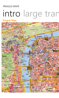
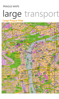
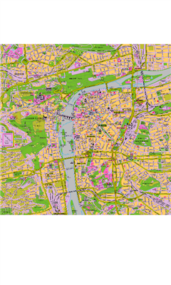
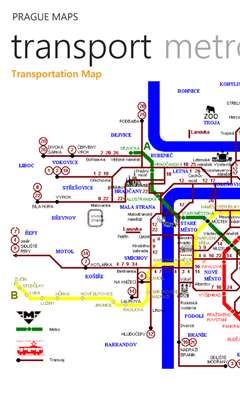
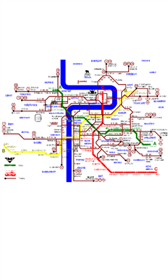
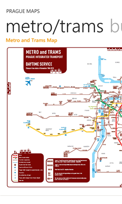
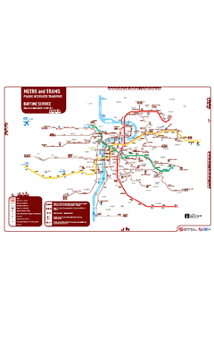
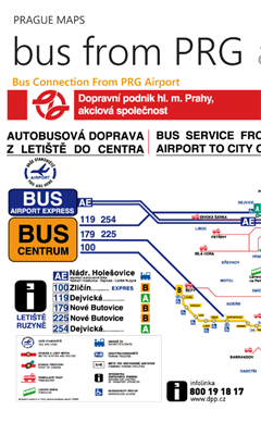
Prague Maps - This app contains offline (no data plan/reception necessary) public transportation maps for the Prague area, including tourist maps, metro/tram maps, and the Airport Express, which takes you from Prague Airport to popular the main train station, Hlavni Nadrazi.
Includes:
tourist maps, with points of interest
transportation map
metro/tram map
Airport Express map
Can be used in portrait or landscape view.
Like it? Share with your friends!
If you got an error while installing Themes, Software or Games, please, read FAQ.
Supported operating systems:
Windows 10 Mobile, Windows Phone 7, Windows Phone 8
Similar Software:
Underground Maps Underground Maps - Contain maps of all Underground of europe. When you want go in the underground you must have Underground Maps that help you to find the rapid way! It's very important install program on Pocket PC and not on Memory Card Ecc.
Map of Oregon (US State) Map of Oregon (US State) - A map of the Oregon by VITO Technology. Good for intercity travels with SmartMap.
SmartMap is a mobile device application which uses vector and raster maps. It is compatible with any NMEA protocol GPS receiver (Compact Flash socket, serial port, BlueTooth or sleeve)
Map of Yemen Map of Yemen - A map of Yemen. Good for intercity travels with SmartMap.
Layers include:
Towns
Settlements
Airports
Roads
Railroads
Rivers
Inland water
Administrative borders
International borders
Trees
Map scale is 1:1 million.
Good for use with any version of SmartMap. SmartMap can be purchased here
Map of South Korea Map of South Korea - A map of South Korea. Good for intercity travels with SmartMap.
Layers include:
Towns
Settlements
Airports
Roads
Railroads
Rivers
Inland water
Administrative borders
International borders
Trees
Map scale is 1:1 million.
Good for use with any version of SmartMap
Simple OSM Simple OSM is a robust OpenStreetMap (OSM) client to browse and search in maps from the OpenStreetMap project (openstreetmap.org).
OpenStreetMap provides much more geographical and poi data than other well-known maps on the internet. Furthermore it is growing supremely fast
Earth&Sun for Pocket PC Earth&Sun for Pocket PC - The Earth&Sun an application for Ewe enabled computers. It shows the Sun Illuminated area of the Earth
Some will consider Earth&Sun to fall into the category of "fun and games".
We hope you find Earth&Sun useful and enjoy it.
· The latitude and longitude of an Earth location
Map of Tunisia Map of Tunisia - A map of Tunisia. Good for intercity travels with SmartMap.
Layers include:
Towns
Settlements
Airports
Roads
Railroads
Rivers
Inland water
Administrative borders
International borders
Trees
Map scale is 1:1 million.
Good for use with any version of SmartMap. SmartMap can be purchased here
RideSchedulesCUMTD RideSchedulesCUMTD - The RideSchedules application is a full-featured public transit assistant that includes updatable schedules, countdowns, maps, favorite stops, directions, guides, tracking tools, alarms, announcements, parking meter, vehicle finder, realtime vehicle locations, offline support, and convenient access to transit provider services
Map of Oklahoma (US State) Map of Oklahoma (US State) - A map of the Oklahoma by VITO Technology. Good for intercity travels with SmartMap.
SmartMap is a mobile device application which uses vector and raster maps. It is compatible with any NMEA protocol GPS receiver (Compact Flash socket, serial port, BlueTooth or sleeve)
Other Software by developer «Pegus Co»:
San Jose Facts San Jose Facts - San Jose Facts app features information about San Jose, California in the following 11 sections:
1. About San Jose
2. History
3. Geography
4. Climate
5. Demographics
6. Economy
7. Attractions
8. Sports
9. Government
10. Education
11
Charlotte Facts Charlotte Facts - Charlotte Facts app features information about Charlotte, North Carolina in the following 11 sections:
1. About Charlotte, North Carolina
2. History
3. Geography
4. Climate
5. Demographics
6. Economy
7. Attractions
8. Sports
9. Government
10. Education
11
Miami Facts Miami Facts app features information about Miami, FL in the following 12 sections:
1. About Miami
2. Geography
3. Climate
4. Parks
5. Neighborhoods
6. Entertainment
7. Education
8. Media
9. Sports
10. Economy
11. Demographics
12
Fort Worth Facts Fort Worth Facts - Fort Worth Facts app features information about Fort Worth, Texas in the following 11 sections:
1. About Fort Worth
2. History
3. Geography
4. Climate
5. Demographics
6. Economy
7. Attractions
8. Sports
9. Government
10. Education
11
Phoenix Facts Phoenix Facts app features information about Phoenix, AZ in the following 12 sections:
1. About Phoenix
2. Geography
3. Climate
4. Cityscape
5. Government
6. Culture
7. Education
8. Media
9. Sports
10. Economy
11. Demographics
12
Boston Facts Boston Facts app features information about Boston, MA in the following 12 sections:
1. About Boston
2. Geography
3. Climate
4. Crime
5. Neighborhoods
6. Culture
7. Education
8. Media
9. Sports
10. Economy
11. Demographics
12
Chicago Maps Chicago Maps - Offline (no data connection necessary!) public transportation maps for the Chicago area. Click on the thumbnails and zoom in for a detailed look.
Includes:
1. an overview of the Chicago Transit Authority system with the ability to zoom into different sections using a map and/or a list
2. Night Owl bus map
Can be used in portrait or landscape view
Dallas Facts Dallas Facts - Dallas Facts app features information about Dallas, Texas in the following 11 sections:
1. About San Diego
2. History
3. Geography
4. Climate
5. Demographics
6. Economy
7. Attractions
8. Sports
9. Government
10. Education
11
Philadelphia Facts Philadelphia Facts app features information about Philadelphia, PA in the following 12 sections:
1. About Philadelphia
2. Geography
3. Climate
4. Crime
5. Neighborhoods
6. Culture
7. Education
8. Media
9. Sports
10. Economy
11. Demographics
12
Houston Facts Houston Facts app features information about Houston, TX in the following 12 sections:
1. About New York City
2. Geography
3. Climate
4. Cityscape
5. Government
6. Culture
7. Education
8. Media
9. Sports
10. Economy
11. Demographics
12


")


")


