Transit Maps USA Free - The only Transit Maps app of its kind. You can select the city you want to see the transit maps for and zoom in to view the map in detail on the full screen. You can easily zoom-in, pan, and zoom-out using one hand only. You can now plan your trip from anywhere, any time - no Internet/data connection required. Imagine having the ease of mind that you will always know what line to catch to go where you want to go.
Give it a try. Your satisfaction is guaranteed.
Please download and rate the app. Provide your feedback via the Marketplace - all comments are read and individually considered.
Tip: Double-tap the zoomed-in map to reset zoom.
The feature history of the application is as below:
Version 1.0 (Current Version)
====================
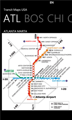
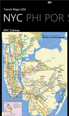
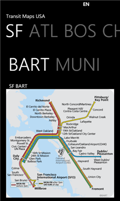
* Transit Maps available for following cities:
- Atlanta
- DC, Washington
- New York City
- San Francisco
* Supports Portrait and Landscape orientation modes
If you would like to get maps for more cities, get the full version of the app at http://social.zune.net/redirect?type=phoneApp&id=e8398409-b46f-e011-81d2-78e7d1fa76f8 The full version contains maps from Boston, Chicago, Los Angeles, Miami, Philadelphia, Portland and more cities.
Like it? Share with your friends!
If you got an error while installing Themes, Software or Games, please, read FAQ.
Supported operating systems:
Windows 10 Mobile, Windows Phone 7, Windows Phone 8
Similar Software:
Speereo Voice Translator: English-Turkish (WM) Speereo Voice Translator (SVT) is an ideal companion for traveling on business or leisure and also is an excellent aid for business communication. Running on Windows Mobile and Symbian based mobile devices it contains of over 4000 phrases in each of 16+ languages and many other useful features
Map of Wyoming (US State) Map of Wyoming (US State) - A map of the Wyoming by VITO Technology. Good for intercity travels with SmartMap.
SmartMap is a mobile device application which uses vector and raster maps. It is compatible with any NMEA protocol GPS receiver (Compact Flash socket, serial port, BlueTooth or sleeve)
KingMAP2 USA-Michigan Electronic Map KingMAP2 USA-Michigan Electronic Map is an Electronic Map Navigation Software exclusively for Pocket PC use; besides powerful functions provided for car navigation, it also comprises integrated Electronic Map functions with an abundant information database.
KingMAP™ 2 Features:
-Latest version Europe electronic map database*
-Advanced Car Navigation Technology
MyGPS PDA MyGPS_PDA - a light version of MyGPS software for Pocket PC systems. It reads the NMEA sentences coming from a GPS device connected to the Pocket PC and shows your position on a calibrated map. A calibrated map can be generated using MyGPS for PC and starting from any raster image file (.bmp, .jpg, .gif). MyGPS_PDA requires the Ewe VM installed on the Pocket PC
redBANG Hong Kong 18 TOP SIGHTS 2006 THE BEST MOBILE GRAPHICS YOU HAVE EVER SET YOUR EYES ON
This TOP 18 sights map contains all THE TOP locations at your finger tips. Simple and easy to use multi step zoom in & out function map as well as movement in any direction
Rough Guides Map London Rough Guides Map London... These guides are a series of fantastic interactive maps.
Produced in conjunction with the premier travel publisher Rough Guides.
Discover and explore London using full colour interactive linked maps, in this simple to use PDA version of The Rough Guides London
Traffic Vizzion Traffic Vizzion - IMPORTANT: Do not operate this product while driving; park the vehicle first. It is your sole responsibility to place, secure and use your mobile device in a manner that ensures safe driving
MetroMap Metro map (Moscow, St. Petersburg, Minsk, Kiev, Ekaterinburg, Nizhny Novgorod, Novosibirsk, Samara
Other Software by developer «Paras Wadehra»:
SketchPad SketchPad allows you to draw free hand on a canvas on your device using a vast color palette and to save your sketch to keep for memory and show it to others.
You can also load any existing image (or an already saved sketch) as a background and draw on that. You can do things like draw a moustache on someone's face; complete a saved sketch; or write messages for others
Artist This is an Artist application where a user can draw free hand like an artist and show their creations to their friends
NPR News NPR News - Now you can have your news on the go.
Select from various categories (Headlines, Business, Politics, US, World, Technology or Sports) and read individual news stories.
To view the full story, just select "open in ie" from the menu at the bottom of each article - this is currently a limitation of how NPR feeds are setup and not of the app itself
Tic Tac Toe Lite Tic Tac Toe Lite lets you play against the computer or your friend


")
")
![USA-CT [Connecticut] Map for EagleEye PDA Tracking System](https://static.mobyware.org/data/images/def_program_reduced.png "USA-CT [Connecticut] Map for EagleEye PDA Tracking System")


