GeoCam allows you to time and location stamp your camera phone photos. GeoCam works with and without a Bluetooth GPS. If you have a GPS, latitude, longitude and altitude will be stamped besides the telco provided place name and country. If you do not have a GPS the place name and country will be printed on the photo.
GeoCam features:
Date and Time Stamp
Date Time format follows phone settings.
Location Stamp
GeoCam knows your place name and country without GPS.
GPS Information
Multiformat options of Latitude, Longitude and Altitude.
Comments
User can input Comments and print on the photos
G,C,CO,2D and 3D Sign Display
These signs are displayed on Camera View and help you what information GeoCam has at that moment. See some photo examples below. C blinks when the Cell (Place Name) is not available, C stops blinking when the Cell is available, it is available faster (within minutes) when the phone is outdoor or in motion, CO indicates whether the user comments will be printed, G blinks when the GPS data is invalid or in searching mode, 3D is displayed when latitude, longitude and altitude available or 2D when only latitude and longitude.
Background Option
The text printed on photos can be with or without black background, This helps when the photo and the text color are not contrast enough.
Rectangle Signs
These signs are displayed on Camera View at the bottom and help you know which part of the photo will be covered with the text.
Other Standard Features
Backlight Management, Image Quality Options, Night Mode, Saving Option (Phone Memory or Memory Card), Image Name, Zoom, Online Help.
GeoCam has many uses:
Leisure
Outdoor gaming - treasure hunting.
Travel
When you stop and snap along a highway, railway or on some remote mountain track, years later, the photo will remind you or take somebody else to the same location. Good for archival purposes
Business
MMS site location details for feasibility study in construction, survey, city planning, agricliture, parklands upkeep etc.
Science
Accurately record and picture archeology and historical sites. Use GeoCam for documenting trees and plants for botanical studies and environment tracking.
Weather
Record lighting, snowfall, river flow, tidal waves.
Other
Record car crashes, accident sites ,UFO sightings, crop circles or any other accidental or rare phenomenon.
We will leave other uses to your creative imagination.
Value add the visual content of a photo with WHEN and WHERE details.
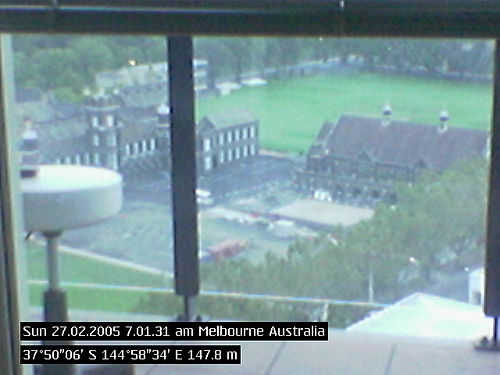
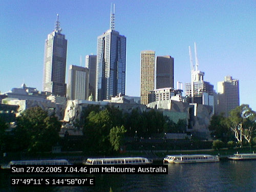
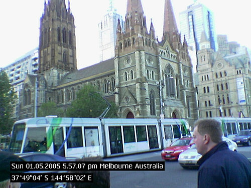
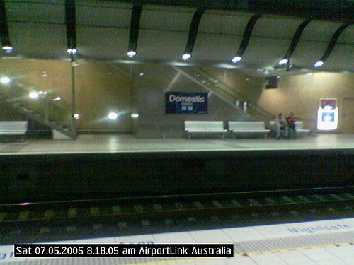
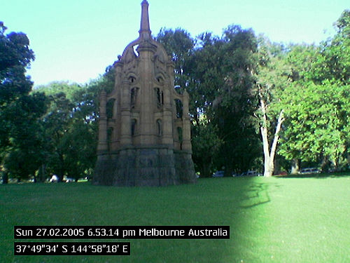
Some Photos taken with full version GeoCam (Nokia 6600):
Photo with full stamp (date, time, place, country, latitude, longitude and altitude) taken when the sign was 3D
Like it? Share with your friends!
If you got an error while installing Themes, Software or Games, please, read FAQ.
Supported operating systems:
S60 2nd Edition
Similar Software:
FON Access Points for Philippines FON Access Points for Philippines - FON offers you a new Points of Interest service (POIs). This allows you to download FONspots directly to your navigation device.
What does that mean? You can download a Points of Interest file directly to your navigation device
SmartCom Navigator for UIQ2 SmartCom Navigator for UIQ2 is an easy to use software with a user friendly interface supporting all necessary functions that will turn your smartphone into a powerful navigation system.
You can use SmartCom Navigator without GPS-receiver for example as a map browsing tool during excursions at an unknown places
Nokia Nearby Nokia Nearby - Don't have maps on your mobile phone as it may not be supported? Have always wanted to have a service to know more about places around you? Now you can do that....even on phones those don't support Maps or don't have GPS
FON Access Points for Spain FON Access Points for Spain - FON offers you a new Points of Interest service (POIs). This allows you to download FONspots directly to your navigation device.
What does that mean? You can download a Points of Interest file directly to your navigation device
Reperion GPS TrailExplorerReperion GPS TrailExplorer Reperion GPS TrailExplorer is a real-time Java Mobile GPS Tracking application. You can upload your GPS position and others can follow you around in Google Earth.
Use of this application is free. It is an adaptation of TrailExplorer.
Users can upload and view their tracks in real-time using a Java mobile phone and GPS device
FON Access Points for Saudi Arabia FON Access Points for Saudi Arabia - FON offers you a new Points of Interest service (POIs). This allows you to download FONspots directly to your navigation device.
What does that mean? You can download a Points of Interest file directly to your navigation device
Voyagaa for UIQ3 Voyagaa for UIQ3 is a navigation application that supports many popular file formats and Bluetooth GPS receivers.
Maps:
ogf2, map files - .ogf2 map image file format and OziExplorer's
Foreca weather Foreca weather- provides current conditions, 10 day weather forecasts and various weather animations for any location world-wide.
You can choose from over 140.000 hand picked locations or you can retrieve forecasts for your current location using your phone's GPS. You can also use the Landmarks in your phone or you can enter a new location by coordinates
FON Access Points for Zambia FON Access Points for Zambia - FON offers you a new Points of Interest service (POIs). This allows you to download FONspots directly to your navigation device.
What does that mean? You can download a Points of Interest file directly to your navigation device
Other Software by developer «GeoPresent Pty Ltd»:
GeoLocateIT GeoLocateIT - Track Locate and Position across Italy with GeoLocateIT
Now you can track another compatible Symbian smart phone across Italy as long as the tracked phone is linked to a blue tooth GPS receiver
phantomEye MySpot SOS phantomEye MySpot SOS - A personal security system for Nokia GPS phones.
What is it:
If you work, live and travel alone then you need this software. MySpot SOS is a software that allows a user to leave behind their location breadcrumbs and notify multiple people when in an emergency . On most cell phones it is as easy as slide and click
GeoViewX GeoViewX - World map, major citites latitude and longitude info, sunset & sunrise times, distance between any two points on map in addition to basic GPS data
GeoLocateES GeoLocateES - Track Locate and Position across Spain with GeoLocateES
Now you can track another compatible Symbian smart phone across SPAIN as long as the tracked phone is linked to a blue tooth GPS receiver
GeoLocateUK GeoLocateUK - Track Locate and Position across UK with GeoLocateUK
Now you can track another compatible Symbian smart phone across the UK as long as the tracked phone is linked to a blue tooth GPS receiver. It is as simple as switching on the GeolocateUK program on your phone and sending a position request to the remote phone
GeoLocateIL GeoLocateIL - Track Locate and Position across Israel with GeoLocateIL
Now you can track another compatible Symbian smart phone across ISRAEL as long as the tracked phone is linked to a blue tooth GPS receiver
GeoLocateFI GeoLocateFI - Track Locate and Position across Finland with GeoLocateFI*
Now you can track another compatible Symbian smart phone across Finland as long as the tracked phone is linked to a blue tooth GPS receiver
GeoLocateDE GeoLocateDE comes with an onboard population center map of 75000 suburbs, towns and cities of Germany. GeoLocateDE allows you to accurately track any vehicle or person carrying a Symbian S60 phone with GeoLocateDE running and connected to a Blue Tooth GPS receiver. You can set tracked contacts with password and then remotely monitor the location of users / vehicles
GeoLocateIN GeoLocateIN - Track Locate and Position across India with GeoLocateIN
Now you can track another compatible Symbian smart phone across INDIA as long as the tracked phone is linked to a blue tooth GPS receiver
GeoLocateFR GeoLocateFR - Track Locate and Position across France with GeoLocateFR
Now you can track another compatible Symbian smart phone across France as long as the tracked phone is linked to a blue tooth GPS receiver