Symbian OS | Pocket PC | Smartphone | Android | BlackBerry | Apple iPhone OS | Java | Mobile Gaming | Linux | Palm | Win CE | Tablet  
     

Free Mobile Software, Themes, Games, Apps for PDA and Smartphones

     
Search by Device
My Device

  
Search by Category
Business & Profession
Databases
Dictionary & Translator
Entertainment
Finance
Games
Healthcare & Medicine
Internet & Communications
Multimedia & Graphics
Organisation & Productivity
Programming & Development
Reading
Science & Education
System Utilities
Themes & Wallpapers & Skins
Travel & Navigation
Search by Platform
Android
Apple iPhone OS
iPad
iPhone
iPod Touch
BlackBerry
Java
Linux
Maemo Nokia Internet Tablet
MeeGO
Sharp Zaurus
Mobile Gaming
Nintendo DS
Playstation 3
Playstation Portable
Wii
Xbox 360
Palm OS
Symbian OS
Series 60
Series 80
Series 90
UIQ
Tablet PC
Windows CE.NET
Windows Mobile Pocket PC
Windows Mobile Smartphone


GpsPilot


GpsPilot
Version: 1.0

Platforms: Symbian OS, Series 60


Categories: Travel & Navigation

Upload date: 25 Nov 10

Developer: Equilibrium

License: Shareware

Price: 18.80 $

Downloads: 412

File Size: 377 Kb


Download Free Trial of GpsPilot 


Rating: 2.3/5 (Total votes: 3)


  GpsPilot- The newest GPS receiver/logger in Your Mobile!
GpsPilot is a software for mobile phones turning your mobile into powerful tool for GPS navigation.

Software here illustrates usage for Pilots to provide flight information, enhancing Your security in the air, but can be configured for all possible mobile applications.
All what you need is: Smartphone with Bluetooth, GPS receiver (mouse) with Bluetooth and this software.

Value of this tool is local - specific to your airfield.
We do not aim high-tech and air-competitions, where the top-pilots are served with special and expensive instruments for flight planning, etc. (Although we can do too). We aim normal, average pilots, instructors and students, serving the day-to-day routine on the Circuit and for flying in Zone. We aim to deliver the value for less, based on GPS, GSM and Mobile phone technology advance.

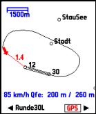
GpsPilot displays three main screens: MAP, Flight and GPS and provides AUDIBLE ALARMS, to assist the Pilot during flight with AUDIBLE information about flight.
And the best: all this is freely configurable for your specific needs! You can define you own alarms and information, to be communicated to you, based on flight data maintained! This feature is especially suitable for Aviation schools & trainings, where a checklists and instructions to student can be played, based on specific flight situation - combined of position & height & speed & direction & duration &?

GpsPilot is delivered with few sample Alarms, Waypoints and Configurations. They are commonly referred as "MODE" of the program. Selected MODE is displayed in the status bar on bottom of every screen. There is a GPS signal status indicator too.

All data are logged ? and Mobile telephone features are deployed: you can send your actual position & flight data per SMS or GPRS in pressing one button. And vice versa: authorized mobiles/computers can retrieve your flight data every time. Logged flight data can be transferred to your favorite flight analysis program later.

MAP screen shows:

  • your position on movable Map (fixed bearing or North), with Scale indicator, zoom, pan and center functions
  • the path being flown
  • Airspeed, needed Height over terrain and Actual height over Terrain
  • Direction and distance to next waypoint
  • major Waypoints and orientation Landmarks (airports, rivers, hills, cities, railways)
Flight screen shows actual and recorded flight data:

  • Airspeed (km/h)
  • Ground speed (km/h)
  • Altitude (HMS)
  • Vario (m/s)
  • Distance - length of the path flown (km)
  • Reserve of height - difference between actual height and height needed (QFE)
  • Trip time - duration of the flight (hh:mm:ss)
  • Max. Speed - maximum Airspeed recorded (km/h)


With Page down, you display second flight screen:

  • Direction - actual direction of flight (degrees)
  • Persistent direction - direction flown in horizontal flight (degrees) - this is to indicate curves
  • Start time (hh:mm:ss)
  • Landing time (hh:mm:ss)
  • Average speed (km/h)
  • Maximal altitude - HMS (m)
  • Minimal altitude - HMS (m)


With Page down, you display a third flight screen:

  • Maximal latitude/longitude reached during flight (DDMM.MMMM)
  • Minimal latitude/longitude reached during flight (DDMM.MMMM)
  • QFE - height over next Waypoint (m)
  • Distance to next waypoint (km)
  • Wind speed (km/h) and direction (degrees)


GPS raw data screen shows raw GPS data, as received from GPS receiver:

  • Latitude
  • Longitude
  • Altitude (HMS)
  • Angle - actual direction of flight (degrees)
  • Mode2
  • Satellites - satellites used
  • Speed (km/h)


With Page down, you display second GPS data screen:

  • Fix indicator - position fix indicator
  • PDOP - position dilution of precision
  • HDOP - horizontal dilution of precision
  • VDOP - vertical dilution of precision
  • Status - data validity status
 
Like it? Share with your friends!

If you got an error while installing Themes, Software or Games, please, read FAQ.
 

Supported operating systems: S60 1st Edition, S60 2nd Edition
 
Similar Software:

Best-Selling US Cities and National Parks Travel Guides CollectionBest-Selling US Cities and National Parks Travel Guides Collection
Best-Selling US Cities and National Parks Travel Guides Collection - illustrated guides and maps. Indulge Yourself with a personal tour guide on Your PDA. 23 guides for the price of 5
Speereo Voice Translator: English-Danish (s60v2)Speereo Voice Translator: English-Danish (s60v2)
Speereo Voice Translator (SVT) is an ideal companion for traveling on business or leisure and also is an excellent aid for business communication. Running on Windows Mobile and Symbian based mobile devices it contains of over 4000 phrases in each of 16+ languages and many other useful features
Speereo Voice Translator: English-FrenchSpeereo Voice Translator: English-French
Speereo Voice Translator: English-French-  is an ideal companion for traveling on business or leisure and also is an excellent aid for business communication. Running on Windows Mobile and Symbian based mobile devices it contains of over 4000 phrases in each of 16+ languages and many other useful features
Travel Rome, Italy - illustrated guide, phrasebook and mapsTravel Rome, Italy - illustrated guide, phrasebook and maps
Travel Rome, Italy - illustrated guide, phrasebook and maps- An illustrated city guide, phrasebook and maps. Indulge Yourself with a personal tour guide on Your PDA. FREE general information chapter, phrasebook and a map in the trial version. Features Fully illustrated. Landmarks map, Street maps, Subway map, and more
GpsMapGpsMap
Use your own maps for displaying your position on a map, even without GPS. Waypoints, compass view also supported
A-Z Birmingham Street Map for S60 1060A-Z Birmingham Street Map for S60 1060
A-Z Birmingham Street Map for S60 1060 - Comprehensive Birmingham street map based on the famous A-Z maps. This is the highest quality map of Birmingham you can buy. Maps are detailed, colourful and clear - exactly the same maps as on the Birmingham A-Z
Travel Canyonlands National Park - illustrated travel guide and mapsTravel Canyonlands National Park - illustrated travel guide and maps
Travel Canyonlands National Park - illustrated travel guide and maps- A comprehensive travel guide illustrated with maps and photographs. Indulge Yourself with a personal tour guide on Your PDA. FREE General Information chapter and a map in the trial version. Features Fully illustrated. Geology, Flora, Fauna and more. Interesting facts. Maps
Tube 2 Paris Pro (UIQ3)Tube 2 Paris Pro (UIQ3)
Tube 2 Paris Pro (UIQ3) - This map package for Tube 2 consists of a fully scrollable detailed map of the Paris metro & RER system and linked high quality street maps of central Paris. Plan journeys on the metro & RER system, list details of the quickest routes and see a superb animated display of your journey tracking around the system map
Nokia Maps SuiteNokia Maps Suite
Nokia Maps Suite - Nokia Maps Suite brings you the future of location-based services. Places helps you discover where to go and Public Transport shows the best way to get there with buses, trams and trains with worldwide coverage
Tube 2 Boston Pro (UIQ)Tube 2 Boston Pro (UIQ)
Tube 2 Boston Pro (UIQ) - This map package for Tube 2 consists of a fully scrollable detailed map of the Boston metro & commuter rail system and linked street maps of central Boston. Plan journeys on the metro system, list details of the quickest routes and see a superb animated display of your journey tracking around the system map
 

Other Software by developer «Equilibrium»:

not found
 

Comments on GpsPilot:

enes1110:
nokia c7

Date: 28 Apr 11

Name:


Comment:


Enter text from image below:

Turn on images!


If you noted an error or download link is broken, please, report it via this page or use comments.
 

Please, select device to check if GpsPilot supports it
 
 
© Pantich 2009 - 2025 All rights reserved.