MetrO finds your way in public transport systems in more than 350 cities around the world (Paris, New York, London, Tokyo, any city with a subway & many more!).
· Fully assisted station search (various lists selection or text entry options)
· Station list for each line
· Recently used stations history
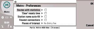
· Operating hours management (in selected cities)
· Places of interest: tourism, night life, ... and detailed information (in selected cities)
· Line deactivation option (in case of strikes or works)
· Line colors in the stop list and in the calculation results
· Contacts list interface (enter your contact's subway stations only once)
· Install only the cities you need (and save memory)
· Extension card compatibility
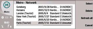
· City databases exchange through IR interface
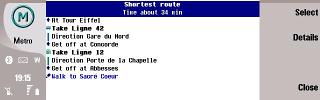
· Two different routes suggested (fastest and least connections)
· More than 250 cities included, most of them with complete information (575 stations in London, 785 in New-York, 1600 in Tokyo, 839 in Paris), including suburban systems, buses, trams, ferries...
· Frequent updates (every month) for up-to-date information
· Available in 34 languages
What's New in This Release:
· New city: Reading, PA (USA)
· Major city changes: Atlanta, Brussels, Busan, Los Angeles, Torino, Toulouse
· Other changes: Amiens, Bilbao, Bratislava, Brisbane, Delhi, Dubai, Guangzhou, Madrid, Metz, Mexico, Milano, Nagoya, Napoli, New York, San Francisco, São Paulo, Tehran
What's New in 5.9.3:
· New city: Montreuil (France, with Bagnolet)
· Major city changes: Annecy, Bagnolet, Beijing, Santiago de Chile, Shenzhen
· Other changes: Arcachon, Athens, Berlin, Bratislava, Bremen, Brno, Colmar, Delhi, Dresden, Frankfurt, Geneva, Kazan, Kharkiv, Kiev, Košice, Moscow, New York, Nuremberg, Osaka, Oslo, Paris, Porto, Prague, Saint Petersburg, San Francisco, Seoul, Shanghai, Tokyo, Vienna, Žilina, Zurich
What's New in 5.9.2:
· New city: Pirna (Germany)
· Major city changes: Bamberg, Bern, Bratislava, Guangzhou, Santander, Toulouse, Vitoria-Gasteiz
· Other changes: Augsburg, Barcelona, Berlin, Boston, Braunschweig, Buenos Aires, Buracaramanga, Dallas, Delhi, Frankfurt, Hanover, Istanbul, Köln/Cologne, Lausanne, London, Madrid, Manila, México, Mulhouse, Munich, Nitra, Nuremberg, Paris, Prague, Prešov, Shanghai, Strasbourg, Stuttgart, Taipei, Tokyo, Wroclaw, Zürich
What's New in 5.9.1:
· New cities: Argenteuil (France), Bagnolet (France), Chengdu (China)
· Major city changes: Amiens, Bogotá, Bratislava, Brisbane, Budapest, Lille, Marseille, Nantes, Quimper, Strasbourg, Toulon
· Other changes: Bangkok, Barcelona, Delhi, Den Haag, Dubai, Dublin, Guangzhou, Košice, Le Mans, Leipzig, London, Lyon, Madrid, Manchester, Miercurea Ciuc / Csikszereda, Moscow, New York, Novosibirsk, Osaka, Paris, Prague, Rotterdam, San Francisco, São Paulo, Shenyang, Tehran, Toulouse, Tours, Vienna
· Minor improvements
Like it? Share with your friends!
If you got an error while installing Themes, Software or Games, please, read FAQ.
Requirements:Nokia 9300, 9500, etc
Supported operating systems:
S80 7.0
Similar Software:
MetrO UIQ MetrO finds your way in public transport systems in more than 350 cities around the world (Paris, New York, London, Tokyo, any city with a subway & many more!)
Tube 2 San Francisco (UIQ) Tube 2 San Francisco (UIQ) - This map package for Tube 2 consists of a fully scrollable detailed map of the San Francisco metro & rail systems.
The maps in this package cover the BART, SCVTA & Caltrain systems plus the Municipal Metro, Municipal Historic Street Car and Cable Car systems in central SF
GETrack GETrack - Now you can record tracking data from your bluetooth GPS receiver and send the track via bluetooth to your PC for direct use with "Google Earth". For business, holidays and fun.
There's no need for any conversion software on the PC side. The tracking data is ready to be used with "Google Earth"
GB Major Road Atlas (UIQ3) GB Major Road Atlas (UIQ3) - This map package is an essential addition to your Tube 2 maps if you drive in and around Great Britain.
This reference map gives you a clear view of all the major roads in the whole of Great Britain, you can use the quick find feature to locate any of the 30,000 + GB towns and villages in the database
Travel Grand Teton National Park - illustrated travel guide and maps Travel Grand Teton National Park - illustrated travel guide and maps- is a comprehensive travel guide illustrated with maps and photographs. Indulge Yourself with a personal tour guide on Your PDA. FREE General Information chapter and a map in the trial version.
Features
Fully illustrated.
Geology, Flora, Fauna and more.
Interesting facts
Map of Utah (US State) Map of Utah (US State) - A map of the Utah by VITO Technology. Good for intercity travels with SmartMap.
SmartMap is a mobile device application which uses vector and raster maps. It is compatible with any NMEA protocol GPS receiver (Compact Flash socket, serial port, BlueTooth or sleeve)
Speereo Voice Translator: English-German (UIQ2) Speereo Voice Translator (SVT) is an ideal companion for traveling on business or leisure and also is an excellent aid for business communication. Running on Windows Mobile and Symbian based mobile devices it contains of over 4000 phrases in each of 16+ languages and many other useful features
Map of Oman Map of Oman - A map of Oman, divided into 8 smaller territories for the ease of use.
MUSANDAM
AL BATINAH
AL ZANIRAH
MASQAT
AD DAKHILIYAH
ASH SHARQIYAH
AL WUSTA
ZUFAR
Good for intercity travels with SmartMap
Speereo Voice Translator: English-German (s60v2) Speereo Voice Translator (SVT) is an ideal companion for traveling on business or leisure and also is an excellent aid for business communication. Running on Windows Mobile and Symbian based mobile devices it contains of over 4000 phrases in each of 16+ languages and many other useful features
Tube 2 Los Angeles (UIQ3) Tube 2 Los Angeles (UIQ3) - This map package for Tube 2 consists of a fully scrollable detailed map of the Los Angeles rail system.
Plan journeys on this system, list details of the quickest routes and see a superb animated display of your journey tracking around the system map
Other Software by developer «P.Bernard, F. Van Caenegem»:
MetrO (UIQ) MetrO (UIQ) - Metro finds your way in public transport systems in more than 350 cities around the world (Paris, New York, London, Tokyo, any city with a subway & many more!)
PCPilot PCPilot - gives you the ability to control MS PowerPoint, Windows Media Player or iTunes on your Windows PC from your Palm device.
Use your Palm as a remote control for your PC
Connect through a Bluetooth or network (e.g
MetrO Smartphone Metro helps you find your way in the public transport systems
MetrO (S80) MetrO (S80) - Metro finds your way in public transport systems in more than 350 cities around the world (Paris, New York, London, Tokyo, any city with a subway & many more!)
MetrO Pocket PC Metro finds your way in public transport systems in more than 350 cities around the world (Paris, New York, London, Tokyo, any city with a subway & many more!).
FREE, FAST & ACCURATE
MetrO (iPhone/iPad) MetrO (iPhone/iPad) - MetrO helps you find your way in the public transportation in more than 400 cities around the world.
One application for all your trips: download the cities you need and search your route by subway, bus, railway, tram ... (depending on cities). NO network connection is required after you have installed the cities
MetrO S60 3rd Metro finds your way in public transport systems in more than 350 cities around the world (Paris, New York, London, Tokyo, any city with a subway & many more!)
MetrO (S90) MetrO (S90) - Metro finds your way in public transport systems in more than 350 cities around the world (Paris, New York, London, Tokyo, any city with a subway & many more!)
MetrO (Maemo) MetrO (Maemo) - Metro finds your way in public transport systems in more than 350 cities around the world (Paris, New York, London, Tokyo, any city with a subway & many more!)
MetrO (iPhone) MetrO (iPhone) - MetrO helps you find your way in the public transportation in more than 400 cities around the world.
One application for all your trips: download the cities you need and search your route by subway, bus, railway, tram ... (depending on cities). NO network connection is required after you have installed the cities


_programView.jpg)

")

")

")
")

")
")
")


")

")

")
")
")