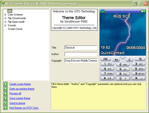
VITO ThemeEditor - FREE for non-commercial use PC-based application that allows you to create your own themes for using on the P900. Start with basic settings, such as defining a default color scheme, then set backgrounds for every screen element, and finish your masterpiece with creating advanced masks and image patterns. Every setting is optional, and you can skip any step.
Variety of settings for both Flip Open and Flip Closed modes, options for editing sounds and screen saver bring endless opportunities to customize your P900.
Created themes can be saved as a single file and transferred to the P900 or exchanged with your friends and other people.
This application is free for non-commercial use. If you want to offer your themes as commercial products, you have to purchase the commercial licence.
Like it? Share with your friends!
If you got an error while installing Themes, Software or Games, please, read FAQ.
Supported operating systems:
UIQ 2.0
Similar Software:
Magic Themes for P800 Magic Themes - With Magic Themes, your old Sony Ericsson P800 will look like a new P900, because now you can use P900 themes (UTZ files) right on the device! This sounds unbelievable, but it is.
Magic Themes is a useful utility that allows you to change almost everything on your smartphone
Other Software by developer «VITO Technology»:
VITO Weather VITO Weather - Weather is a Windows Mobile software for getting weather forecast right on your mobile device. It has intuitive and finger-friendly interface.
Weather was designed specially for Winterface - next generation Windows Mobile shell. When added to Winterface there appears a special Weather icon among other status icons with “live” info
Map of Wisconsis (US State) Map of Wisconsis (US State) - A map of the Wisconsis by VITO Technology. Good for intercity travels with SmartMap.
SmartMap is a mobile device application which uses vector and raster maps. It is compatible with any NMEA protocol GPS receiver (Compact Flash socket, serial port, BlueTooth or sleeve)
Map of New Mexico (US State) Map of New Mexico (US State) - A map of the New Mexico by VITO Technology. Good for intercity travels with SmartMap.
SmartMap is a mobile device application which uses vector and raster maps. It is compatible with any NMEA protocol GPS receiver (Compact Flash socket, serial port, BlueTooth or sleeve)
Map of Vermont (US State) Map of Vermont (US State) - A map of the Vermont by VITO Technology. Good for intercity travels with SmartMap.
SmartMap is a mobile device application which uses vector and raster maps. It is compatible with any NMEA protocol GPS receiver (Compact Flash socket, serial port, BlueTooth or sleeve)
Map of Nepal Map of Nepal - A map of Nepal. Good for intercity travels with SmartMap.
Layers include:
Towns
Settlements
Airports
Roads
Railroads
Rivers
Inland water
Administrative borders
International borders
Trees
Map scale is 1:1 million.
Good for use with any version of SmartMap. SmartMap can be purchased here
VITO QuickContact UIQ QuickContact is a simple yet powerful contact manager adapted for ONE HAND operation. Extremely useful for those who never use the flip. The main feature of QuickContact is a character-specific search method. Based on alphabetic filtering of names in the list it helps to operate hundreds of your contacts in a flash, much faster then a built-in Contacts can provide
Geo Walk HD Geo Walk HD - Concise Encyclopedia of Surprising Facts at Hand! Discover the world around you with simple and educational application that collects amazing and fun facts about all the most interesting things of our planet
Gyrocompass 3D Free Gyrocompass 3D Free - Augmented reality comes to the new iPod Touches! Tap the Gyrocompass 3D application on your iPhone 4 or 4th generation iPod Touch to turn it into a fully functioning three-dimensional compass
Map of Uruguay Map of Uruguay - A map of Uruguay. Good for intercity travels with SmartMap.
Layers include:
Towns
Settlements
Airports
Roads
Railroads
Rivers
Inland water
Administrative borders
International borders
Trees
Map scale is 1:1 million.
Good for use with any version of SmartMap. SmartMap can be purchased here
Map of Serbia Map of Serbia - A map of Serbia good for intercity travels with SmartMap.
Layers include:
Towns
Settlements
Airports
Roads
Railroads
Rivers
Inland water
Administrative borders
International borders
Trees
Map scale is 1:1 million.
Good for use with any version of SmartMap. SmartMap can be purchased here


")
")
")


