GeoSense - Ever wondered how you would know if you have reached a destination you've never been before? GPS is great .. but should you be checking out the GPS on a regular basis just to make sure? Or what if you Sleep off?
Why not tag an alarm to a specific location? Even if this is possible, can I be notified before I've reached the place? GeoSense does just that !!!
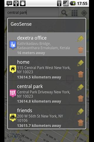
GeoSense is an unique application that helps you remember and reminds you of locations.
· Add any number of locations to from the map.
· Location alerts to each hotspot.
· Location reminders when you come within the specified proximity.
· Add categories to POIs
· Lists POIs based on distance from you.
· Intelligent battery use.
Like it? Share with your friends!
Supported operating systems:
Google Android 1.5, Google Android 1.6, Google Android 10.x, Google Android 2.0, Google Android 2.1, Google Android 2.2, Google Android 2.3, Google Android 3.0, Google Android 3.1, Google Android 3.2, Google Android 4.0, Google Android 4.1, Google Android 4.2, Google Android 4.3, Google Android 4.4, Google Android 5.x, Google Android 6.x, Google Android 7.x, Google Android 8.x, Google Android 9.x
Similar Software:
FindShip FindShip - Find any ship all over the world! With FindShip, you can track your vessel' movements realtime on the mapFeatures:• * Nearly 80,000 ships online.• * Covering most ports on the world.• * Detail ship's information. In addition to AIS information, D.W.T/Gross ton/Build year is also provided.• * Powerfull ship/port search engine
amAze (Motorola) AmAze is a first of its kind free navigation and local search service. It is free to download and use and it contains wide coverage of maps including aerial photo in Europe, North America, Australia and parts of Asia and Africa
LAS MobileTracker LT LAS MobileTracker LT - The LAS MobileTracker LT is an easily configured app to read GPS coordinates from an Android OS phone or tablet. Every five minutes, the coordinates and user ID are uploaded to our website from anywhere on the planet that has internet access. A GeoTag button also takes a ''snapshot'' of your location
GoPenS GoPenS is an OpenSource GPS application for Android phones, based on OpenStreetMap (OSM). OpenStreetMap is a collaborative map of the world. Therefore, one of the main functions of the application is to be able to record a trace and send it as a GPX to the OSM servers, and so edit the OSM Map
Nav4All (Android) With Nav4All you can navigate worldwide on your own mobile phone.
You will never lose your way again and you will always know where you and your friends are located.
You get access to over 1 billion addresses on MyWorld, including Yellow Pages, phonebooks, etc.
While you're on the road you can easily save an interesting location by pressing one button
iTrack Free iTrack Free - iTrack is a real time tracking your friend location application. You and your friend must both install this application. Click menu to show current online users; Click your friend and make a request.Your friend will be notified and response your request
BlueGPS4Droid BlueGPS4Droid is an application for using an external Bluetooth GPS on Android devices.
The application starts a service, then connects to a Bluetooth device (NMEA GPS) and creates a mock GPS provider which can be used to replace the internal GPS.
It's also possible to log the external GPS NMEA data in a file on the device
Back2It Back2It is not just a car locator.
With one click, you may mark places like:
- parking lots
- favorite restaurants
- museums
- theaters
- public park
...
and 1 click to go back with GPS navigation on Google Map.
Switch to Google Map for route
Foursquare Foursquare - helps you explore the world around you. Keep up with friends, get insider tips, and unlock discounts and rewards.
While on the go, you can easily tell friends where you are, share pictures, get their comments ("I'm right around the corner, I'll stop by to say hello"), and get insider tips ("order the Lobster Ravioli; it's the best dish by far
GPS Widget GPS Widget - This widget simply shows your current location in numbers. Latitude and Longitude are received from the GPS location provider or from the network location provider if GPS is not available.
The altitude is queried from open MapQuest API which yields in a more accurate result than receiving the altitude by GPS
Other Software by developer «Dexetra»:
Tintumon: Rebirth Tintumon: Rebirth - The kingdom of Mallusia is under siege by the Evil Kanka and his men
SpeedSense SpeedSense turns your Android phone into a virtual Dashboard. You get all sorts driving info, such as:
* Top Speed
* Avg


")


")


