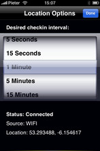
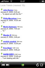
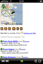
Locle is a mobile application that lets users see where their friends and family are without the need for GPS. Wherever you are, always find out where people are and meet them for lunch, drinks or whatever you want to do. Just make sure you don't miss out on anything.
Like it? Share with your friends!
If you got an error while installing Themes, Software or Games, please, read FAQ.
Supported operating systems:
Google Android 1.0, Google Android 1.5, Google Android 1.6, Google Android 10.x, Google Android 2.0, Google Android 2.1, Google Android 2.2, Google Android 2.3, Google Android 3.0, Google Android 3.1, Google Android 3.2, Google Android 4.0, Google Android 4.1, Google Android 4.2, Google Android 4.3, Google Android 4.4, Google Android 5.x, Google Android 6.x, Google Android 7.x, Google Android 8.x, Google Android 9.x, Java ME, Java Nokia 240x320, Java SE 240x320, Palm OS 3.x, Palm OS 4.x, Palm OS 5.x, Pocket PC 2002, RIM BlackBerry OS 4.0, RIM BlackBerry OS 4.1, RIM BlackBerry OS 4.2, RIM BlackBerry OS 4.3, RIM BlackBerry OS 4.5, RIM BlackBerry OS 4.6, RIM BlackBerry OS 4.7, RIM BlackBerry OS 5.0, RIM BlackBerry OS 6.0, Windows Mobile 2003, Windows Mobile 5.0, Windows Mobile 6 Classic, Windows Mobile 6 Professional, Windows Mobile 6.1 Classic, Windows Mobile 6.1 Professional, Windows Mobile 6.5 Professional
Similar Software:
TrekBuddy Trekbuddy is a J2ME application to be used with a GPS receiver. It is designed to work with every Java-enabled device. It features capabilities such as: * GPS tracking and simple navigation * bitmap maps (without zoom, you can store bitmap maps with different resolution instead)
BeOnMyMap (Android) BeOnMyMap The Android mobile device application for the BeOnMyMap.Com service. BeOnMyMap is a location based socialisation application, consisting of the BeOnMyMap.com website, a mobile website for use on your mobile phone (BeOnMyMap.mobi) and integrated applications for mobile devices
OSMTracker for Android OSMTracker stands for OpenStreetMap Tracker. It allows you to track your journey and mark significant way points. Way points can be marked with a tag using a button, with a quick voice record, a text note or by taking a picture. The various button pages and layouts can be customized to suit your OpenStreetMap activities
Latitude Launcher Latitude isn't enabled in the UK, and some other countries, on the T-Mobile G1, however it is enabled on many other phones e.g. Nokia N95. This is frustrating, a Google phone without Google Latitude.
Latitude Launcher can enable Latitude for you if you have 'Rooted' your phone
amAze (LG) AmAze is a first of its kind free navigation and local search service. It is free to download and use and it contains wide coverage of maps including aerial photo in Europe, North America, Australia and parts of Asia and Africa
amAze (Android) AmAze is a first of its kind free navigation and local search service. It is free to download and use and it contains wide coverage of maps including aerial photo in Europe, North America, Australia and parts of Asia and Africa
ShareYourDrive ShareYourDrive Transportation and cars especially are contaminating. Imagine with a few clicks, you can know who can give you a ride. The time real geolocalisation to save environment. Don't be afraid about security. Historic helps to know who was with you, when and where. Moreover you can give a rate to the persons you meet
CoPilot Live UK + Ireland (Android) CoPilot Live UK + Ireland (Android) - CoPilot Live is full-featured voice-guided GPS navigation with street maps of 1 European region stored on your Android phone. Includes 3D guidance, lane assist, speed limit warnings, safety camera alerts, planning mode.
Download maps via WiFi after purchase. Unlimited use after 10 days once Google order verified
Map Explorer Map Explorer is a prototype that tries to improve map browsing experience. It is basically Google maps with an overlay that shows POIs even if they are beyond the display. Use the preferences to test different visualizations


")

")
")

")
