GPS speed camera warning application for Android devices. Radardroid will give a visual and audible warning when you approach any fixed or mobile speed camera in the application database. This application will give you advanced warning of possible danger ahead and will reduce possible speeding tickets thanks to the ever increasing available features. We do not condone speeding and will not be held responsible for anybody prosecuted for breaking the law.
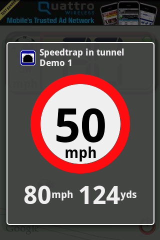
· Voice warnings telling speed camera type and road limit (users can customize these warnings).
· Visual and audible warnings.
· Vibrator warnings (very useful for bikers).
· Change the application settings to prevent the phone to switch off the screen or let the phone dim of switch the screen off to improve your battery life. Even if the screen is off, the application will show the warning dialog, turning the screen on again if needed.
· Day and Night modes.
· Select your screen orientation: portrait, landscape or automatic.
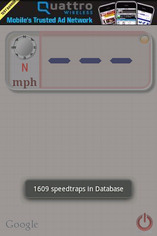
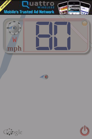
· Radardroid main window is an interactive map which shows the closest speed camera locations. Radardroid also incorporates a digital speedometer that shows your speed and direction.
· Download Speed Camera Database directly from SpeedCameraPOI.com. Keep your database updated with just one click.
· Import your preferred Speed Camera Database from your SD card.
Like it? Share with your friends!
Supported operating systems:
Google Android 1.0, Google Android 1.5, Google Android 1.6, Google Android 10.x, Google Android 2.0, Google Android 2.1, Google Android 2.2, Google Android 2.3, Google Android 3.0, Google Android 3.1, Google Android 3.2, Google Android 4.0, Google Android 4.1, Google Android 4.2, Google Android 4.3, Google Android 4.4, Google Android 5.x, Google Android 6.x, Google Android 7.x, Google Android 8.x, Google Android 9.x
Similar Software:
MapMyHike+ for Android MapMyHike+ for Android - MapMyHike is a mobile assistant designed to allow hikers to track their activities using their phone's built-in GPS.
With the app you can view your route on a map and record your trip details, including duration, distance, pace, speed and elevation.
You can also share the details of your activity with friends via Facebook, Twitter or email
Place Nearby Place Nearby - This application is all about searching for a desire location on map anytime, anywhere or anyplace.
This application just required a high speed internet connection, Network / GPS enabled device to search for your desire location.
This application will show you the live traffic near by your present location
OSMTracker for Android OSMTracker stands for OpenStreetMap Tracker. It allows you to track your journey and mark significant way points. Way points can be marked with a tag using a button, with a quick voice record, a text note or by taking a picture. The various button pages and layouts can be customized to suit your OpenStreetMap activities
OS Map OS Map is a tool to turn your Android phone into a handy Ordnance Survey map, with your GPS position pinpointed on it!
· Nearly all OS Map scales available (including 250,000 and 50,000).
· Touch-scrolling - simply use your finger to drag the map around.
· Fast resume from standby and fast position updates
POSIT POSIT (Portable Open Search and Identification Tool) is a Humanitarian Free and Open Source Software project to use the Google Android phone as a platform for mobile disaster management applications
Mobilex GPS Logger Mobilex GPS Logger - Overview ========================== The Android GPS Logger application captures GPS updates, and saves latitude and longitude coordinate fixes to text files on micro SD card. Supported Features inlcude: ============================== Google Maps. Satellite, Traffic and Street Views
Local Local - Local is your best application to find any place you are looking for near you. Local offers you so easy and customized search with best filtered results, show you places as per user ratings. You can see complete details of a local place like opening and closing timings, map, Google+ profile, users reviews, price range
Current Location Finder Current Location Finder - Current Location finder which can be used to locate your location with the aid of a live satellite map you can dynamically (real time) determine ... Use the live satellite maps
ParkLeitSystem ParkLeitSystem is a car-park-routing system. It shows you, according to your GPS position, the nearest city with a car-park-routing system and gives you a list with all available car-parkings and shows how many free places there are. With a click on the parking it switches to google maps and shows you the position of the parking
Redpin The aim of the Redpin project is to create an open source system that allows indoor positioning up to room-level description using mobile phones
Other Software by developer «Radardroid»:
not found
Comments on Radardroid Lite:
Comments not found
If you noted an error or download link is broken, please, report it via this page or use comments.
Radardroid Lite is compatible with your device Acer Liquid Jade 2 S58A LTE-A