Maps+ - Maps Plus (Maps+) is an easy to use, powerful way to find directions, points of interest, locations, and anything else you're looking for.
A few of the features in our application:
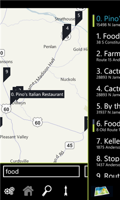
- Quick pop out search list
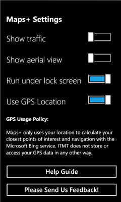
- Traffic overlay
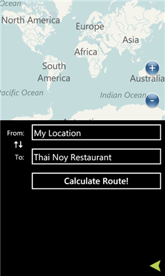
- GPS calculated direction
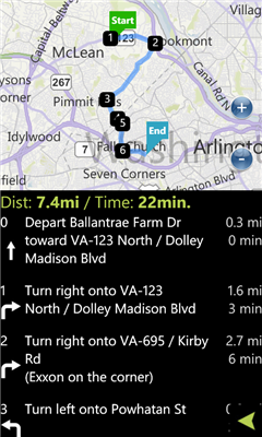
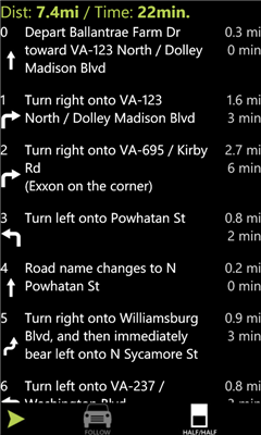
- Route directions with quick switch between map/list mode
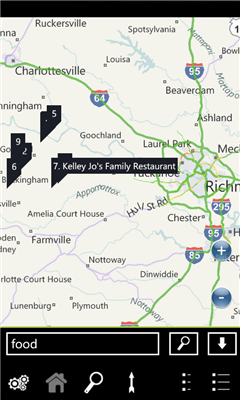
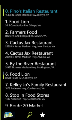
- POI Search
- Favorites
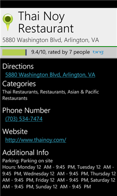
- POI Descriptions including website/phone number/hours
- It's free!
We've optimized the whole experience for speed and ease of use, please provide feedback via the built in feedback button to tell us how we can improve it further for you!
Like it? Share with your friends!
If you got an error while installing Themes, Software or Games, please, read FAQ.
Supported operating systems:
Windows 10 Mobile, Windows Phone 7, Windows Phone 8
Similar Software:
GeoBC Showcase GeoBC Showcase - This app takes advantage of geospatial layers provided by GeoBC. It will include Federal Electoral Districts and Local Health areas plus Primary Survey Parcels in British Columbia, Canada.
Select one of the layers from the list, then press a point on the map and hold to get information about that geographical point
Free World Explorer Free World Explorer - So, you think you are good at geography? Let's see how good you are :)
Pan the map to fly the plane to the destination place and click on land button when you find the green airport symbol. You need to be connected to internet for this. Difficulty mode to challenge you with a lot more countries
Washington SR 520 Toll & Traffic Washington SR 520 Toll & Traffic - Electronic tolling on SR 520 will begin this spring. Be ready by checking how much it will cost you to cross SR 520. Application takes in account US Holidays and provides additional information, such as current crossing time for both directions, and traffic map of the bridges
Offline Maps Offline Maps - Want to save money on your data plan and roaming fees abroad? Download maps and use them without having to use an internet connection!
With this application you can download a map of any part in the world and take it with you when travelling
A-Z London Visitors A-Z London Visitors - Visiting London? Download A-Z's handy free London Visitors' Map. The map provides a quick and simple overview of the major places of interest in London.
For more detailed mapping covering a much greater area, please see our full A-Z of London app (search Marketplace for A-Z London)
Mymaps Mymaps - This is an extra odinary app which collaborates bing maps with gmaps or google maps...just browse on bing with the experience of google maps.
This application is a cross between gmaps and bing maps...
lets call it gingmaps :-p
Cheers and please do review
Vicinity Vicinity automatically locates you and businesses within 1 mile of you, providing 0 click access to everything in your Vicinity. Selecting a search result presents you with a detailed view, including a zoomable map with walking route from your current location
LR Maps LR Maps - This program is the Chinese version of the map program, the layer provided by the Google.Search functions are provided by Google Api and Baidu Api. Main functions are as follows: (1) through the GPS to locate and display the current location (2) Road name search with Chinese input: You can search for example, "Huaihai Road"
SaraMap SaraMap is a Free Map Application that integrates with Google Map,Microsoft Bing Map and OpenStreetMap.it supports GPS Tracking either.
Main Features:
-Map Navigation with different layers support.
-Using Multi Scale Image control as map viewer core with Multi touch pan/zoom behavior.
-Switch easily between Google Map,Bing Map and OpenStreetMap
-GPS Tracking
ver 1
Other Software by developer «Intertouch Media Technologies»:
DCMetro DCMetro - The complete app for the Washington DC Metro! Find the nearest station, check on train arrival times, get directions to a station and more.
Also check up on the most recent disruptions, tweets, and news items published by the metro authority!
Not affiliated with WMATA, all data is gathered from feeds available through WMATA