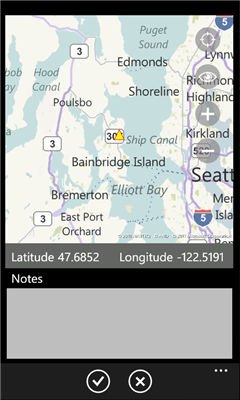
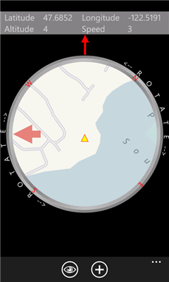
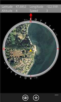
Compass Free application has a GPS compass, Bing maps and waypoints. Helps guide you to home to a car, to a trail head or base camp. Use outside for best results.
Please Note:
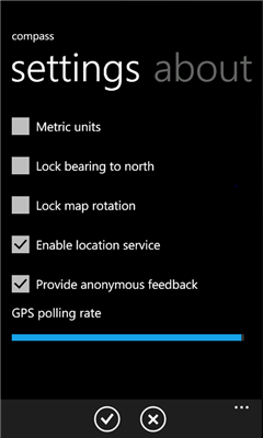
Compass Free uses GPS triangulation to calculate north. A good GPS signal and physical movement over a meter is required. Phones may have a compass sensor but this does not guarantee that applications have access. An update to this application will be released once the compass API is available.
Like it? Share with your friends!
If you got an error while installing Themes, Software or Games, please, read FAQ.
Supported operating systems:
Windows 10 Mobile, Windows Phone 7, Windows Phone 8
Similar Software:
Simple Altimeter Free Simple Altimeter Free - This app answers one simple question: What's my elevation, according to the phone's GPS chip?
Have you ever been hiking, skiing, boarding, or even just driving and wondered what your approximate elevation is? This is the app for you. The best part is that it's free!
Disclaimer: This app is only as accurate as the GPS chip in your phone
Weekend Overdrive Weekend Overdrive shows many useful indicators for passengers on car drive.
Indicators such as compass, clinometer, reverse geo coder, altitude, temperature, twitter helps you recognize your situation
Aide randonnee Aide randonnee - Cette application peut etre tres utile pour vos randonnees, en particulier celles de montagne.
En effet vous pouvez voir la direction vers laquelle le telephone est dirige et vous pouvez aussi voir la hauteur qu'il reste a monter pour atteindre le point culminant de votre randonnee
SpeedChecker SpeedChecker - Displays your current speed, as well as providing graphs for recent speed, acelleration and height. You can also plot your recent drive on a map. Supports speed display as kilometers per hour and miles per hour
Jack of Tools Jack of Tools makes your phone into a virtual tool belt. Want to know exactly where you are? Ever wonder how fast that roller coaster ride really is? How high are you? Or maybe you just want to get that desk level
GPS Utility GPS Utility - GPS Utility helps you converts between all major geographical coordinate systems.
Helpful for excursionists, navigators users (TomTom, garmin, etc.), GeoCaching lovers, and Bing maps enthusiasts
Velocity Lite Velocity Lite - Warns you when you reach a speed limit, and provides you your speed and course.
Upgrade to Velocity full version and you will get history of your speed, distance and altitude and be able to quickly share your location
GPS Distance GPS Distance - GPS Distance vous permet de calculer rapidement et facilement la distance i vol d'aoiseau qu'il y a entre deux coordonnees GPS.
Les coordonnees sont donnees de facon decimales representant la valeur de l'angle en degre et le resultat est donnee en kilometre