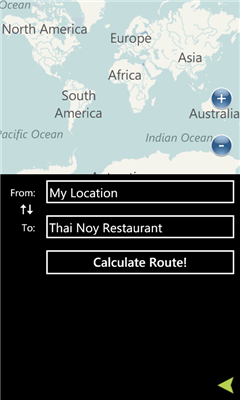
Maps+ - Maps Plus (Maps+) is an easy to use, powerful way to find directions, points of interest, locations, and anything else you're looking for.
A few of the features in our application:
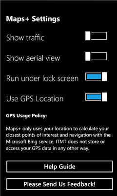
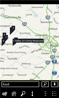
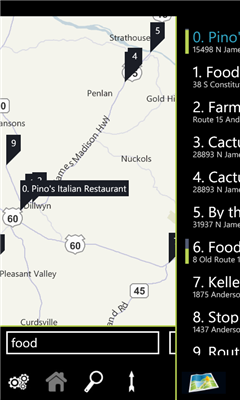
- Quick pop out search list
- Traffic overlay
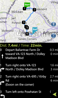
- GPS calculated direction
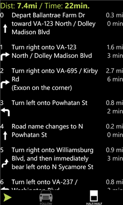
- Route directions with quick switch between map/list mode
- POI Search
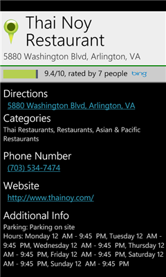
- Favorites
- POI Descriptions including website/phone number/hours
- It's free!
We've optimized the whole experience for speed and ease of use, please provide feedback via the built in feedback button to tell us how we can improve it further for you!
Like it? Share with your friends!
If you got an error while installing Themes, Software or Games, please, read FAQ.
Supported operating systems:
Windows 10 Mobile, Windows Phone 7, Windows Phone 8
Similar Software:
Bochum Total Diese Anwendung ist eine ubersicht uber alle Acts bei Bochum Total und das Bermuda-Dreieck
Washington SR 520 Toll & Traffic Washington SR 520 Toll & Traffic - Electronic tolling on SR 520 will begin this spring. Be ready by checking how much it will cost you to cross SR 520. Application takes in account US Holidays and provides additional information, such as current crossing time for both directions, and traffic map of the bridges
NaMap NaMap - The primary text of the application NaMap is in English and Korean.
English Description:
"Namap" application provide map information providing by Naver Open API
Prague Maps Prague Maps - This app contains offline (no data plan/reception necessary) public transportation maps for the Prague area, including tourist maps, metro/tram maps, and the Airport Express, which takes you from Prague Airport to popular the main train station, Hlavni Nadrazi
ArcGIS ArcGIS is a great way to discover and use maps. Tap on the map or use your current location to discover information about what you see. Search and find interesting information in the map as well as measure distances and areas. Find community hosted maps from ArcGIS Online, ESRI's online GIS, or use the authoring tools on ArcGIS
LR Maps LR Maps - This program is the Chinese version of the map program, the layer provided by the Google.Search functions are provided by Google Api and Baidu Api. Main functions are as follows: (1) through the GPS to locate and display the current location (2) Road name search with Chinese input: You can search for example, "Huaihai Road"
MapStalt Mini MapStalt Mini is an application that is meant to bring the map to completeness. In the case of the open street map, many details are missing, and MapStalt puts to power to complete the map into the hands of the mobile user. With MapStalt, a user can add something as simple as a building address and latitude/longitude or complex details such as business hours of operation
Canada Topography Canada Topography - provides topographic information for the entire country of Canada. The maps provide details such as altitude, railways and numerous other layers. Using the GPS you can center on your current location and even zoom to specific areas of the country.
All maps are provided by Geocratis Canada (http://www.geogratis.gc.ca/geogratis/en/service/toporama
Pocket World Free Pocket World Free is your ultimate pocket guide for over 240 countries around the world. The app that puts the whole world on your fingertips. This free version is full featured, supported by ads
Other Software by developer «Intertouch Media Technologies»:
DCMetro DCMetro - The complete app for the Washington DC Metro! Find the nearest station, check on train arrival times, get directions to a station and more.
Also check up on the most recent disruptions, tweets, and news items published by the metro authority!
Not affiliated with WMATA, all data is gathered from feeds available through WMATA