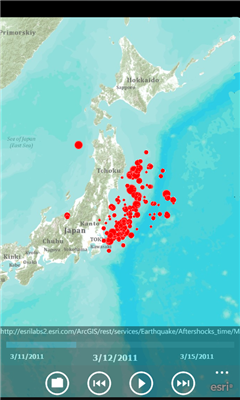
AGMapTime is a simple viewer with time slider features for "time-aware" layer data of ArcGIS services. Time slider lets you browse map features on specific time. You can view various kind of map layers from ArcGIS.com or your own ArcGIS server.
version 0.5 (First version)
- Only supports dynamic layer.
- Fixed base map.
- Slider auto detect time duration.
- Slider tick is roughly defined according to the duration. So the tick sometimes not equal to map's tick.
Like it? Share with your friends!
If you got an error while installing Themes, Software or Games, please, read FAQ.
Supported operating systems:
Windows 10 Mobile, Windows Phone 7, Windows Phone 8
Similar Software:
Map_launcher Map_launcher - WP7 has a several built in launchers, but the map app does not have one. It's unfortunate because I think it's fairly common that you'd want to have a link to get directions in a mobile app since you are, you know, mobile
Puget Sound Traffic Puget Sound Traffic is a simple and quick way to view traffic conditions in the Puget Sound area.
Maps are fetched from the Washington State Department of Transportation as well as other sites for Seattle, Bellevue, Tacoma, Olympia, Bellingham and the US/Canada border. Recent incidents from the WSDOT area also displayed.
Maps are not interactive
Map Compare Map Compare - Map Compare allows you to compare 12 different maps from Bing, Google, Yahoo and Open Street Maps side by side on a single screen
Canada Topography Canada Topography - provides topographic information for the entire country of Canada. The maps provide details such as altitude, railways and numerous other layers. Using the GPS you can center on your current location and even zoom to specific areas of the country.
All maps are provided by Geocratis Canada (http://www.geogratis.gc.ca/geogratis/en/service/toporama
MapStalt Mini MapStalt Mini is an application that is meant to bring the map to completeness. In the case of the open street map, many details are missing, and MapStalt puts to power to complete the map into the hands of the mobile user. With MapStalt, a user can add something as simple as a building address and latitude/longitude or complex details such as business hours of operation
Pocket World Free Pocket World Free is your ultimate pocket guide for over 240 countries around the world. The app that puts the whole world on your fingertips. This free version is full featured, supported by ads
Mymaps Mymaps - This is an extra odinary app which collaborates bing maps with gmaps or google maps...just browse on bing with the experience of google maps.
This application is a cross between gmaps and bing maps...
lets call it gingmaps :-p
Cheers and please do review
LR Maps LR Maps - This program is the Chinese version of the map program, the layer provided by the Google.Search functions are provided by Google Api and Baidu Api. Main functions are as follows: (1) through the GPS to locate and display the current location (2) Road name search with Chinese input: You can search for example, "Huaihai Road"
Chicago Maps Chicago Maps - Offline (no data connection necessary!) public transportation maps for the Chicago area. Click on the thumbnails and zoom in for a detailed look.
Includes:
1. an overview of the Chicago Transit Authority system with the ability to zoom into different sections using a map and/or a list
2. Night Owl bus map
Can be used in portrait or landscape view