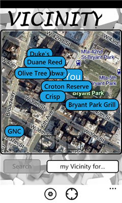
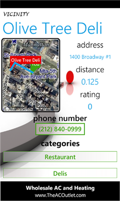
Vicinity automatically locates you and businesses within 1 mile of you, providing 0 click access to everything in your Vicinity. Selecting a search result presents you with a detailed view, including a zoomable map with walking route from your current location. Enter your own search term if you're looking for something specific, or use the categories from the details page to see what's around!
Like it? Share with your friends!
If you got an error while installing Themes, Software or Games, please, read FAQ.
Supported operating systems:
Windows 10 Mobile, Windows Phone 7, Windows Phone 8
Similar Software:
WorldMaps Developed by Salman Shakeel
This application provides you total solution to navigation it is combinations of multiple maps at one place
GeoBC Showcase GeoBC Showcase - This app takes advantage of geospatial layers provided by GeoBC. It will include Federal Electoral Districts and Local Health areas plus Primary Survey Parcels in British Columbia, Canada.
Select one of the layers from the list, then press a point on the map and hold to get information about that geographical point
XMaps XMaps - With xMaps you have the possibility to use the worldwide map data from openstreetmaps.org on your phone. xMaps comes without any map data, you can download any maps in different zoom levels for free. You can zoom in / out and rotate and tilt the map.
Use xMaps to search a point by coordinate or to plan a travel route by car or by foot
Bingle Maps Bingle Maps is a full featured map application. Other than the commonly desired features like Search, Routing and Itineraries, it allows you to drop unlimited personal pins and synchronize them with your DropBox account, not to mention that it also integrates with Google Maps.
Highlights:
- You can choose to use either Bing Maps or Google Maps
GMaps GMaps - Free Google Maps for Windows Phone 7
Now available the following features:
1. Map navigation with different layers support
2. GPS tracking
3. "What is here"
4. Search for location
We appreciated your feedback
Prague Maps Prague Maps - This app contains offline (no data plan/reception necessary) public transportation maps for the Prague area, including tourist maps, metro/tram maps, and the Airport Express, which takes you from Prague Airport to popular the main train station, Hlavni Nadrazi
Mr.Map Mr.Map help users to find any place on the world using world map
Chicago Maps Chicago Maps - Offline (no data connection necessary!) public transportation maps for the Chicago area. Click on the thumbnails and zoom in for a detailed look.
Includes:
1. an overview of the Chicago Transit Authority system with the ability to zoom into different sections using a map and/or a list
2. Night Owl bus map
Can be used in portrait or landscape view