Categories: Business & Profession, Travel & Navigation
Upload date: 18 May 11
Developer: Dimension Srl
License: Freeware
Downloads: 638
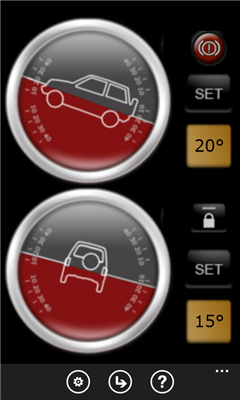
Landmeter - Call it inclinometer, call it clinometer, call it levels, call it whatever you like ... but you don't have enough of them ... There is still one missing ...
LandMeter is the official inclinometer for all off-roads enthusiasts, 4x4 cars, trucks, jeep, landrover, and trailers.
Take control of your car pitching and rolling with your Windows Phone with our dashboard accessory!
---------------
- Landscape or portrait view;
- Separate calibration for pitching and rolling;
- Disable automatic lock of your WP7 (in-car charger suggested);
- Numeric display for accurate pitching and rolling measurement;
- Set an alarm when you reach a certain inclination!
- "Viscosity" features, for a better, realistic and precise movements!
Suggestions or features requests, contact us at iphone@dimension.it
Like it? Share with your friends!
If you got an error while installing Themes, Software or Games, please, read FAQ.
Supported operating systems:
Windows 10 Mobile, Windows Phone 7, Windows Phone 8
Similar Software:
GPS Utility GPS Utility - GPS Utility helps you converts between all major geographical coordinate systems.
Helpful for excursionists, navigators users (TomTom, garmin, etc.), GeoCaching lovers, and Bing maps enthusiasts
Time To Go Time To Go - Time to Go is a simple tool to help you figure out how much time is remaining until you arrive at your destination. Simply put in your current speed and distance remaining (in MPH) and Time to Go will display your remaining time in hours, it's that simple!
Change Log
------------------------------------------------------------------
Version 1.1
Pocket Cockpit Pocket Cockpit simulates all six basic flight instruments, including airspeed indicator, attitude indicator, altimeter, variometer, turn indicator and heading indicator. It's ideal for aviation enthusiasts, both experienced and amateur, who want to feel like they're flying an airplane even while walking down the street
SpeedChecker SpeedChecker - Displays your current speed, as well as providing graphs for recent speed, acelleration and height. You can also plot your recent drive on a map. Supports speed display as kilometers per hour and miles per hour
World Map It is a an app which tells you and latitude and longitude of the world in map
Simple Altimeter Free Simple Altimeter Free - This app answers one simple question: What's my elevation, according to the phone's GPS chip?
Have you ever been hiking, skiing, boarding, or even just driving and wondered what your approximate elevation is? This is the app for you. The best part is that it's free!
Disclaimer: This app is only as accurate as the GPS chip in your phone
Coordinate Checker Check the latitude and longitude for a location on the world using this app. Just indicate a location in the world using your finger and the coordinates will be showed
Compass Free Compass Free application has a GPS compass, Bing maps and waypoints. Helps guide you to home to a car, to a trail head or base camp. Use outside for best results.
Features include:
• GPS Compass
• GPS Accuracy warnings
• Bing Maps
• Waypoints
Please Note:
Compass Free uses GPS triangulation to calculate north
Driving Forces Driving Forces is a speedometer and G-Force meter: together at last! Mark your top speed and greatest Gs in 3 dimensions
Other Software by developer «Dimension Srl»:
GPS Utility GPS Utility - GPS Utility helps you converts between all major geographical coordinate systems.
Helpful for excursionists, navigators users (TomTom, garmin, etc.), GeoCaching lovers, and Bing maps enthusiasts