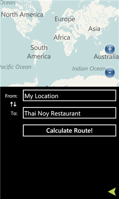
Maps+ - Maps Plus (Maps+) is an easy to use, powerful way to find directions, points of interest, locations, and anything else you're looking for.
A few of the features in our application:
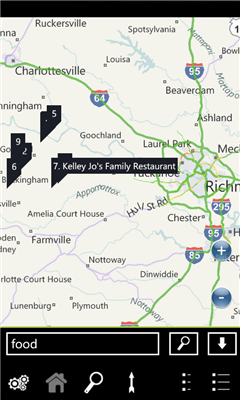
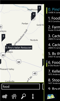
- Quick pop out search list
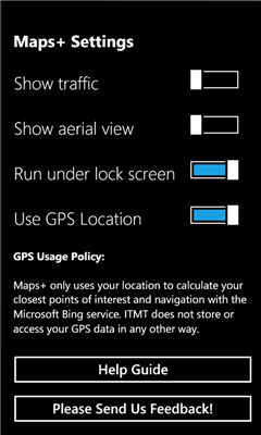
- Traffic overlay
- GPS calculated direction
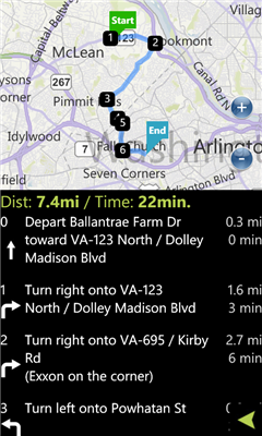
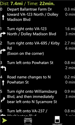
- Route directions with quick switch between map/list mode
- POI Search
- Favorites
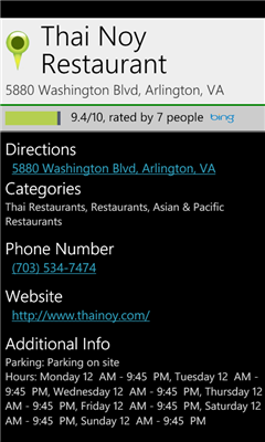
- POI Descriptions including website/phone number/hours
- It's free!
We've optimized the whole experience for speed and ease of use, please provide feedback via the built in feedback button to tell us how we can improve it further for you!
Like it? Share with your friends!
If you got an error while installing Themes, Software or Games, please, read FAQ.
Supported operating systems:
Windows 10 Mobile, Windows Phone 7, Windows Phone 8
Similar Software:
Wenak Mobisoft Wenak lets you share your location with your friends, family members, co-workers and loved ones by making it easy to tell them where you are and see each other on the map.
Wenak lets you share your location in the background, even when the app is closed
Pocket World Free Pocket World Free is your ultimate pocket guide for over 240 countries around the world. The app that puts the whole world on your fingertips. This free version is full featured, supported by ads
GMaps GMaps - Free Google Maps for Windows Phone 7
Now available the following features:
1. Map navigation with different layers support
2. GPS tracking
3. "What is here"
4. Search for location
We appreciated your feedback
Bochum Total Diese Anwendung ist eine ubersicht uber alle Acts bei Bochum Total und das Bermuda-Dreieck
AGMapTime AGMapTime is a simple viewer with time slider features for "time-aware" layer data of ArcGIS services. Time slider lets you browse map features on specific time. You can view various kind of map layers from ArcGIS.com or your own ArcGIS server.
version 0.5 (First version)
- Only supports dynamic layer.
- Fixed base map.
- Slider auto detect time duration
Simple OSM Simple OSM is a robust OpenStreetMap (OSM) client to browse and search in maps from the OpenStreetMap project (openstreetmap.org).
OpenStreetMap provides much more geographical and poi data than other well-known maps on the internet. Furthermore it is growing supremely fast
Washington SR 520 Toll & Traffic Washington SR 520 Toll & Traffic - Electronic tolling on SR 520 will begin this spring. Be ready by checking how much it will cost you to cross SR 520. Application takes in account US Holidays and provides additional information, such as current crossing time for both directions, and traffic map of the bridges
MapStalt Mini MapStalt Mini is an application that is meant to bring the map to completeness. In the case of the open street map, many details are missing, and MapStalt puts to power to complete the map into the hands of the mobile user. With MapStalt, a user can add something as simple as a building address and latitude/longitude or complex details such as business hours of operation
Bing This app helps to use the bing map with just a click
Other Software by developer «Intertouch Media Technologies»:
DCMetro DCMetro - The complete app for the Washington DC Metro! Find the nearest station, check on train arrival times, get directions to a station and more.
Also check up on the most recent disruptions, tweets, and news items published by the metro authority!
Not affiliated with WMATA, all data is gathered from feeds available through WMATA