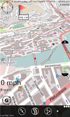
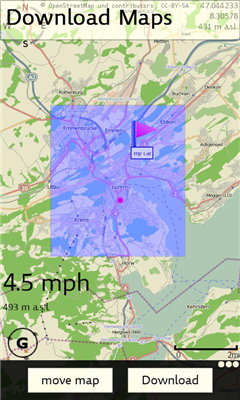
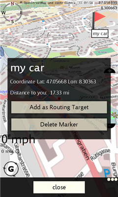
XMaps - With xMaps you have the possibility to use the worldwide map data from openstreetmaps.org on your phone. xMaps comes without any map data, you can download any maps in different zoom levels for free. You can zoom in / out and rotate and tilt the map.
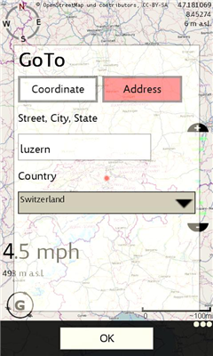
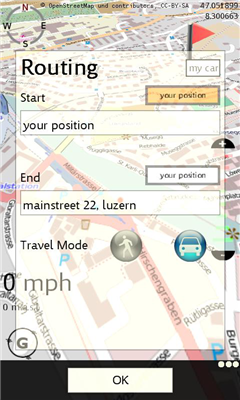
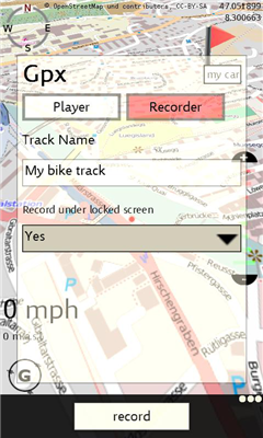
Use xMaps to search a point by coordinate or to plan a travel route by car or by foot. You have the possibility to add markers for your favorite places. With the GPX Recorder you can record a track and view it later on the GPX Viewer. xMaps is ideal for travelling, hiking or biking.
Like it? Share with your friends!
If you got an error while installing Themes, Software or Games, please, read FAQ.
Supported operating systems:
Windows 10 Mobile, Windows Phone 7, Windows Phone 8
Similar Software:
Puget Sound Traffic Puget Sound Traffic is a simple and quick way to view traffic conditions in the Puget Sound area.
Maps are fetched from the Washington State Department of Transportation as well as other sites for Seattle, Bellevue, Tacoma, Olympia, Bellingham and the US/Canada border. Recent incidents from the WSDOT area also displayed.
Maps are not interactive
FidMe FidMe - Toutes vos cartes de fidélité réunies sur votre mobile !
FidMe, le portecarte mobile pour vos cartes de fidélité !
Innovante et simple à utiliser FidMe : enregistrez vos cartes de fidélité en quelques secondes
Chicago Maps Chicago Maps - Offline (no data connection necessary!) public transportation maps for the Chicago area. Click on the thumbnails and zoom in for a detailed look.
Includes:
1. an overview of the Chicago Transit Authority system with the ability to zoom into different sections using a map and/or a list
2. Night Owl bus map
Can be used in portrait or landscape view
You Are Here You are lost and don't have a GPS? Don't worry, this application always shows you where you are, with a precision of 50 centimeters!
GMap Pro GMap Pro - Ultimate Google Maps for Windows Phone 7
In new version we have added China region detection and offset auto correction. We have also improved navigation by adding auto rerouting and current step highlighting.
We appreciate your feedback. Help us make tool you’d like
Googlemaps Googlemaps - Enjoy Almost all features of Google Maps on your WindowsPhone7
Enjoy The Water-overlay mode, Physical mode, Hybrid mode, Satellite View, Street-View.
You can zoom in and zoom out without any Hindrance
Vicinity Vicinity automatically locates you and businesses within 1 mile of you, providing 0 click access to everything in your Vicinity. Selecting a search result presents you with a detailed view, including a zoomable map with walking route from your current location
ArcGIS ArcGIS is a great way to discover and use maps. Tap on the map or use your current location to discover information about what you see. Search and find interesting information in the map as well as measure distances and areas. Find community hosted maps from ArcGIS Online, ESRI's online GIS, or use the authoring tools on ArcGIS
MapStalt Mini MapStalt Mini is an application that is meant to bring the map to completeness. In the case of the open street map, many details are missing, and MapStalt puts to power to complete the map into the hands of the mobile user. With MapStalt, a user can add something as simple as a building address and latitude/longitude or complex details such as business hours of operation
Other Software by developer «itrona GmbH»:
XBalance XBalance ist eine Wasserwaage fur dein Telefon