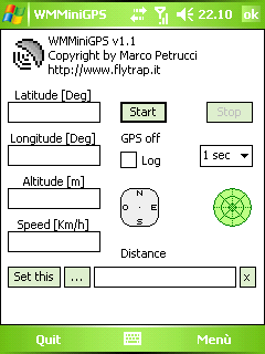
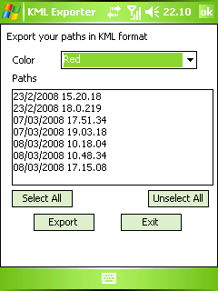
WMMiniGPSis a Windows Mobile 5/6 software which gets your GPS data in a really simple gui, showing you latitude, longitude, altitude and speed. It can log all to file and it can export your paths to Google Earth's kml and gpx format.
There's a compass, which shows your direction and you can set latitude and longitude of a point and the program will show you the way to reach it with a radar, telling you how many meters / kilometers there are to cover.
What's New in This Release:
· fixed export dialog box problem
Like it? Share with your friends!
If you got an error while installing Themes, Software or Games, please, read FAQ.
Supported operating systems:
Windows Mobile 5.0, Windows Mobile 6 Classic, Windows Mobile 6 Professional, Windows Mobile 6.1 Classic
Similar Software:
GPS Tuner Atlas Full Version with South America Basic Map Content GPS Tuner Atlas Full Version with South America Basic Map Content is designed specifically for off-road use: its large buttons, selectable tool window size, multiple Compass views and the built-in Tele Atlas map makes it extremely user-friendly and reliable
GPSMapings GPSMapings uses the GPS on your PocketPC to find your current location and allows you to view your position on a map from the Google.com maps service. You can customize the maps zoom, and type via the 'Options' in the toolbar. The maps service is provided by Google
TwitterGPSing TwitterGPSing allows you to send GPS based tweets to Twitter. When you get a GPS lock enter the text and tap the button to send the Tweet with your current GPS. The program will send the tweet to Twitter.com with your current GPS. NOTE: To use Geolocation on Twitter in 'Settings/Account/Tweet Location' enable. This service is provided by Twitter
BT747 MTK GPS Datalogger Device Control BT747 MTK GPS Datalogger Device Control - i-Blue 747 / i-Blue 757 / Qstarz BT-Q1000 / i.Trek Z1 / Konet BGL-32 / Holux M-241 / ... control SW (for PalmOS, WinCe (PPC), Java platform, Windows, Linux, and MacOS). Compatible with most MTK GPS based loggers.
What's New in This Release:
· Added M1000C support
What's New in 2.0
IndicatorSpeed IndicatorSpeed uses the GPS on your PocketPC to find your speed and displays it on the task bar of any running PocketPC application. Select Km/Miles or NM and tap the button to start the GPS. The program reports your GPS chip GPRMC speed (Very accurate)
Google Navigator Google Navigator is the most powerful and easy to use GPS navigation software on your Pocket PC. Also is the best and most easy to use and convenient software on your Pocket PC. All map data is transferred from Google via network, and save permanently on your device until you want to delete it
Map Calibrator Map Calibrator - If you would like to calibrate maps on your desktop PC, use free Map Calibrator program. Map Calibrator is also useful to create map slices from a huge bitmap image file. You can convert GIF, BMP and PNG files into JPG file to use it in GPS Tuner as well
FON Access Points for Chile FON Access Points for Chile - FON offers you a new Points of Interest service (POIs). This allows you to download FONspots directly to your navigation device.
What does that mean? You can download a Points of Interest file directly to your navigation device
amAze (LG) AmAze is a first of its kind free navigation and local search service. It is free to download and use and it contains wide coverage of maps including aerial photo in Europe, North America, Australia and parts of Asia and Africa
FON Access Points for Finland FON Access Points for Finland - FON offers you a new Points of Interest service (POIs). This allows you to download FONspots directly to your navigation device.
What does that mean? You can download a Points of Interest file directly to your navigation device
Other Software by developer «Marco Petrucci»:
not found
Comments on WMMiniGPS:
Comments not found
If you noted an error or download link is broken, please, report it via this page or use comments.
WMMiniGPS is compatible with your device Acer n300/n310/n311/n321


")
