Rough Guides Map New York City... These guides are a series of fantastic interactive maps.
Produced in conjunction with the premier travel publisher Rough Guides.
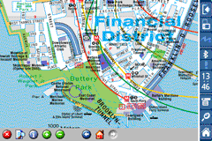
Discover and explore New York City using full colour interactive linked maps, in this simple to use PDA version of The Rough Guides New York City.
Find all the top tourist spots and key attractions with ease, information on the city and its sights can be quickly displayed with links to photographs and map locations. All in a superb easy to use interface.
If you''re travelling to New York City, be sure you don''t leave home without this guide on your PDA.
The Rough Guide city maps includes:
Fully scrollable and interactive maps of the city.
Tap any location to display information and available links.
Intuitive navigation bar meaning you are never more than one click away from the information you require.
Map links allow you to directly link to other maps, photographs, or detailed views.
Categorised Find feature allowing you to quickly find any street, place of interest or station.
Categorised Information feature providing a wealth of information on the city, places of interest, etc.
1-Click Home feature, keeping the Home map always at hand.
Zoom function on all maps.
Special Offer Only $20.00
Hi Res & landscape displays supported.
Like it? Share with your friends!
If you got an error while installing Themes, Software or Games, please, read FAQ.
Supported operating systems:
Pocket PC 2002, Windows Mobile 2003, Windows Mobile 5.0, Windows Mobile 6 Classic, Windows Mobile 6 Professional, Windows Mobile 6.1 Classic, Windows Mobile 6.1 Professional, Windows Mobile 6.5 Professional
Similar Software:
Rough Guides Map Dublin Rough Guides Map Dublin... These guides are a series of fantastic interactive maps.
Produced in conjunction with the premier travel publisher Rough Guides.
Discover and explore Dublin using full colour interactive linked maps, in this simple to use PDA version of The Rough Guides Dublin
Map of Athens / Greece for City Advisor Map of Athens / Greece for City Advisor
Instructions:
1. Download the map (zip file)
2. Extract the files in /CityAdvisor/maps
3. Open CityAdvisor -> Maps icon -> Menu -> Refresh
4
A-Z Great Britain Super Scale Road Map 2009 A-Z Great Britain Super Scale Road Map 2009 - This publication has been designed for a Windows® Mobile-based Pocket PC (version 2002 or later) and The Pocket A-Z Viewer (included)
Map of Beijing (Chinese) / China for City Advisor Map of Beijing (Chinese) / China for City Advisor is a Chinese version of Beijing Metro map. Type the first letter of Pinyin to search.
Instructions:
1. Download the map (zip file)
2. Extract the files in /CityAdvisor/maps
3. Open CityAdvisor -> Maps icon -> Menu -> Refresh
4
Map of Panama Map of Panama - A map of Panama. Good for intercity travels with SmartMap.
Layers include:
Towns
Settlements
Airports
Roads
Railroads
Rivers
Inland water
Administrative borders
International borders
Trees
Map scale is 1:1 million.
Good for use with any version of SmartMap. SmartMap can be purchased here
amAze (LG) AmAze is a first of its kind free navigation and local search service. It is free to download and use and it contains wide coverage of maps including aerial photo in Europe, North America, Australia and parts of Asia and Africa
London Underground by Zuti London Underground by Zuti - "London Underground 10" is a superb map and route planner for the London Underground, Overground and Docklands Light Railway (DLR) services. So you can make a quick exit when you leave the train we have now added exit information for all stations on the London Underground
Chicago Metro by Zuti Chicago Metro by Zuti - Chicago Metro map makes it easy to travel in and around the city using the CTA rapid transport system, the commuter services of Metrarail, Northern Indiana Commuter Transportation District and also the Water Taxi services
London Bus Free London Bus Free - The new Zuti London Bus map has finally arrived, making it easy to travel by bus anywhere in central London. This clear and colourful map covers a detailed street level area of 6 miles by 4 miles and includes over 1300 bus stops and 189 bus routes
Rome Metro for iPad by Zuti Rome Metro for iPad by Zuti - The Zuti Rome Metro application is a superb geographically based map and route planner for the Metro, Tram, Urban and Regional rail systems. Unlike old fashioned schematic style maps this product contains a geographically accurate central area showing major streets, parks and places of interest etc, allowing the user to easily get their bearings
Tube Vienna (Series 60) Tube Vienna (Series 60) - Our highly acclaimed Tube application that guides you around the metro system of Vienna is now available for your Series 60 Symbian powered phone. An essential addition to your phone for locals and tourists alike.
· A detailed clear colour map of the Vienna metro system fully scrollable.
· Quick find station utility
Tube 2 Los Angeles (UIQ3) Tube 2 Los Angeles (UIQ3) - This map package for Tube 2 consists of a fully scrollable detailed map of the Los Angeles rail system.
Plan journeys on this system, list details of the quickest routes and see a superb animated display of your journey tracking around the system map
Tube 2 Beijing Geo (Palm OS) Tube 2 Beijing Geo (Palm OS) - This superb map package for Tube 2 is the ideal map for anyone who needs to get around Beijing using the public transport system.
The map is a comprehensive map of the Beijing subway system system accurately overlaid onto an informative street map
Tube 2 Budapest (Palm OS) Tube 2 Budapest (Palm OS) - This map package for Tube 2 consists of a fully scrollable detailed map of the Budapest metro system and HEV suburban railway.
Plan journeys on this system, list details of the quickest routes and see a superb animated display of your journey tracking around the system map
London Master A-Z for iPad London Master A-Z for iPad - This clear and colourful high quality map covers the same area as the market leading A-Z "Master Atlas of Greater London Street Atlas". The familiar look makes this by far the easiest London iPad map to use. The map is drawn by real cartographers with the detailed care and the human touch of emphasis and colour that A-Z are famous for
Tube 2 San Francisco (Palm OS) Tube 2 San Francisco (Palm OS) - This map package for Tube 2 consists of a fully scrollable detailed map of the San Francisco metro & rail systems.
The maps in this package cover the BART, SCVTA & Caltrain systems plus the Municipal Metro, Municipal Historic Street Car and Cable Car systems in central SF


 Hi Res & landscape displays supported.

![USA-WY [Wyoming] Map for EagleEye PDA Tracking System](https://static.mobyware.org/data/images/def_program_reduced.png "USA-WY [Wyoming] Map for EagleEye PDA Tracking System")

 / China for City Advisor")

")
")


")
")
")
")

")