TouringNavigation - It is a navigation application program for the motorcycle and the bicycle, etc.
It is a navigation application for the motorcycle and the bicycle, etc.
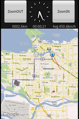
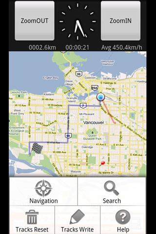
This application displays the route guide, tracks, the mileage that has been passed, the running time , and the mean time velocity.
Tracks that have been passed also provide the function to output to the SD card by the GPX format.(GPS Logger)
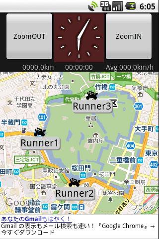
This application provides the location sharing service "Where everyone?".
"Where everyone?" is ability to understand each other, where you are now someone else on the map.
*** Let's try "Where everyone?" ***
Please push Menu button,
and tap the 'Where everyone?' button.
The Input dialog is displayed.
Input keyword 'test' and Tap 'OK' button.
The map is displayed, Please see aroud Tokyo Japan.
you can see 4 test runnners.
Like it? Share with your friends!
Supported operating systems:
Google Android 1.5, Google Android 1.6, Google Android 2.0, Google Android 2.1, Google Android 2.2, Google Android 2.3, Google Android 3.0, Google Android 3.1
Similar Software:
MarineTraffic.com MarineTraffic.com - Real-time ships positions based on Automatic Identification System (AIS). Watch the positions reported by more than 35000 vessels per day on an interactive Google map.
The application provides worldwide coverage of more than 850 ports and a significant number of open-sea areas.
Port arrivals and departures are recorded in real-time
Redpin The aim of the Redpin project is to create an open source system that allows indoor positioning up to room-level description using mobile phones
yozi yozi is a navigation software for the Android platform. It uses digital topographic maps in well-known Ozi Explorer formats for navigation and doesn't require network access like built-in Maps application on Android
OpenGPSTracker OpenGPSTracker adds the capability to store and review where you and your Android device have been. Basically you press record at the start of your trip and your phone stores the route you take. This route is drawn real-time on the Maps functionality of Android or in the background with an idle device. The route is stored on your phone for review and further use
Android Photo GeoTag Android Photo GeoTag - Take pictures with your mobile phone and incorporate the data of the geographical location. The application allows you to include in the photographs, data from the GPS receiver, along with a brief note. If you know the coordinates, not having the GPS receiver, you can also handwrite geographic data
GPS Speedometer & Flashlight GPS Speedometer & Flashlight - GPS Speedometer & Flashlight is a free app for Android devices with built-in GPS receiver. It functions as a normal speed gauge found in every car, displaying the velocity of the vehicle.
In addition, the software includes an easy to use flashlight
e-Mobile family locator e-Mobile family locator - Easily find friends and family by sending a text message from your phone or web.
Locate device and people
* Locate people and lost device by sending a "locate" text message.
* Generate a ringtone on missing device by sending a "ping" text message
MapMyRIDE GPS Cycling Riding MapMyRIDE GPS Cycling Riding - tracks the route, distance, pace, and more in real-time using GPS.
NEW: iMapMyRIDE+ for Android
iMapMyRIDE+ brings you its mobile app for Android-based devices! Now owners of Android 2
CoPilot Live Australia & NZ (Android) CoPilot Live Australia & NZ (Android) - Get a CoPilot! The onboard GPS navigation app that makes every journey better


")
