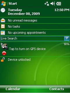
GPS2day is a today screen plug-in showing your current GPS coordinates, speed, satellite info, etc... Languages: English, Czech, Dutch, French, German, Hungarian, Italian, Japanese, Polish, Russian, Spanish.
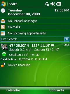
Currently GPS2day program works as GPS informer. It supports both metric and U.S. (Imperial) units and shows a various types of information for users, such as:
Current geographical coordinates (latitude, longitude);
Course and speed;
Some information about satellites and fix type;
Altitude followed by the fix 3D value;
Exact current date and time from the satellite atomic clock;
And battery life state which is important when you using GPS device.
What's New in This Release:
· Translation to Japanese was added
Like it? Share with your friends!
If you got an error while installing Themes, Software or Games, please, read FAQ.
Supported operating systems:
Windows Mobile 5.0, Windows Mobile 6 Classic, Windows Mobile 6 Professional, Windows Mobile 6.1 Classic, Windows Mobile 6.1 Professional, Windows Mobile 6.5 Professional
Similar Software:
TwitterGPSes TwitterGPSes allows you to view the current GPS and status of your Twitter contacts. Enter the name of each contact to assign to a button. When you tap on the button the persons Twitter page will be downloaded and a Google.com map will display the location. This service is provided by Twitter
Map of Rome / Italy for City Advisor Rome / Italy map for City Advisor.
Instructions:
1. Download the map (zip file)
2. Extract the files in /CityAdvisor/maps
3. Open CityAdvisor -> Maps icon -> Menu -> Refresh
4
Travel Miami Beach and Miami - city guide and maps Travel Miami is a comprehensive travel guide to Miami. Indulge Yourself with a personal tour guide on Your PDA. FREE General Information chapter in the trial version.
Features
Fully illustrated.
Historical overviews.
Interesting facts.
City Maps.
Museums address, telephone, hours and admission information.
Easy to navigate
VITO AstroNavigator II AstroNavigator takes all the beauty of the night sky and puts it right on the screen of your device
Travel Ireland - illustrated guide and maps. Incl: Dublin, Cork, Galway and more. FREE General Info Travel Ireland - illustrated guide and maps. Incl: Dublin, Cork, Galway and more. FREE General Info - An illustrated guide and maps. Indulge Yourself with a personal tour guide on Your PDA. FREE General Information chapter and a map in the trial version.
Features
Fully illustrated.
Historical overviews.
Interesting facts.
City Attractions
amAze (LG) AmAze is a first of its kind free navigation and local search service. It is free to download and use and it contains wide coverage of maps including aerial photo in Europe, North America, Australia and parts of Asia and Africa
Tube London City Streets (2009 Edition) Tube London City Streets
This Tube package consists of a fully scrollable detailed map of the London Underground system and 9 linked GPS enabled A-Z street maps.
Plan journeys on the London Underground system, list details of the quickest routes and see a superb animated display of your journey tracking around the system map
TrekBuddy Trekbuddy is a J2ME application to be used with a GPS receiver. It is designed to work with every Java-enabled device. It features capabilities such as: * GPS tracking and simple navigation * bitmap maps (without zoom, you can store bitmap maps with different resolution instead)
Other Software by developer «Soft Expanse Group»:
ShellSwitcher ShellSwitcher was implemented as a Windows Mobile system utility for fast switching between well known shells: Spb Mobile Shell, Titanium (WM6.5 default shell), Touch Flo 3D, HTC Sense and classic Today screen. This application is based on UI Switcher knowledge with some additional features


")
")

