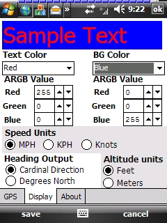
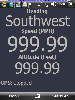
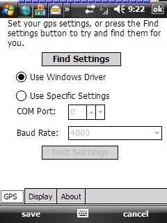
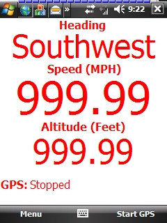
GudenSoft GPS Info An application which shows information from the GPS receiver. It uses both, the Windows Driver, and OpenNETCF's library, so if you have a GPS device, and a Windows Mobile Device, this should work
Like it? Share with your friends!
If you got an error while installing Themes, Software or Games, please, read FAQ.
Supported operating systems:
Windows Mobile 5.0, Windows Mobile 6 Classic, Windows Mobile 6 Professional, Windows Mobile 6.1 Classic, Windows Mobile 6.1 Professional, Windows Mobile 6.5 Professional
Similar Software:
MapTexterer MapTexterer - MapTexterer allows you to create text based GPS maps. When you get a GPS lock then you can create a new map and enter text for the area. When you save the text the map is downloaded and the text and GPS is appended to the end of the map with current GPS.
This program requires that you have both the 'BeanDLL
Gloposis Gloposis is real-time GPS-GPRS Internet navigation, GPS tracking and position exchange system for Windows PCs and Mobile PocketPC devices. You can use your PocketPC to post your position in real-time to Gloposis server and view it from any computer throught web browser interface without any additional software on computer
CalculatorGPSed CalculatorGPSed - CalculatorGPSed is a GPS distance calculator and location finder. You can use the GPS or custom entry on your PocketPC to view and download GPS marked satellite camera pictures and calculates distance between two points specified by the latitude/longitude using "The Vincenty inverse formula for ellipsoids" (accuracy to within 0.5mm, or 0
Wenak Wenak - Mobisoft Wenak lets you share your location with your friends, family members, co-workers and loved ones by making it easy to tell them where you are and see each other on the map. Wenak lets you share your location in the background, even when the app is closed
PictureGPS PictureGPS allows you to tag pictures from your PocketPC camera in real time with a GPS stamp and view the distance of each picture via your current GPS. You can use the ruler to view the distance of each picture and also view the GPS stats for each picture with a Google.com map. The map service is provided by Google
GpsMid Stuttgart GpsMid is a free, fully offline, vector based map application for your mobile phone. It displays your current position on a zoomable map and can be used to search for and navigate to roads or points of interest of your liking. As all data is stored in a compact binary format on your mobile phone you will incur no charges for extra data downloads
FON Access Points for Zimbabwe FON Access Points for Zimbabwe - FON offers you a new Points of Interest service (POIs). This allows you to download FONspots directly to your navigation device.
What does that mean? You can download a Points of Interest file directly to your navigation device
FON Access Points for Jordan FON Access Points for Jordan - FON offers you a new Points of Interest service (POIs). This allows you to download FONspots directly to your navigation device.
What does that mean? You can download a Points of Interest file directly to your navigation device
TaxiGPSer TaxiGPSer - TaxiGPSer uses the GPS on your PocketPC to find your current latitude/longitude/speed and allows you to send it to a preset Taxi or shuttle service via email. Tap the button to get the GPS lock and when the program gets the lock it will send the email.
This program requires that you have both the 'BeanDLL
Traffic Vizzion (12 month subscription) IMPORTANT: Do not operate this product while driving; park the vehicle first. It is your sole responsibility to place, secure and use your mobile device in a manner that ensures safe driving
Other Software by developer «GudenSoft»:
Email Scheduler Email Scheduler is a simple service program for Windows Mobile Devices that will automatically change your email polling settings. This means that just like ActiveSync, you can now have a schedule for all of your email accounts to check for messages
Email Scheduler Email Scheduler is a simple service program for Windows Mobile devices that will automatically change your email polling settings. This means that just like ActiveSync, you can now have a schedule for all of your email accounts to check for messages
RadarLove! RadarLove is a simple Radar image engine that pulls all the image data from the National Weather Service RIDGE system, including most of the overlays.
A few pointers:
* you can click on a location, and it will zoom in on that location. When you do this, the map must not move, otherwise the zoom will not work


")


