Categories: Business & Profession, Travel & Navigation
Upload date: 20 Oct 10
Developer: MrRalphMan
License: Freeware
Downloads: 8466 File Size: 626 Kb
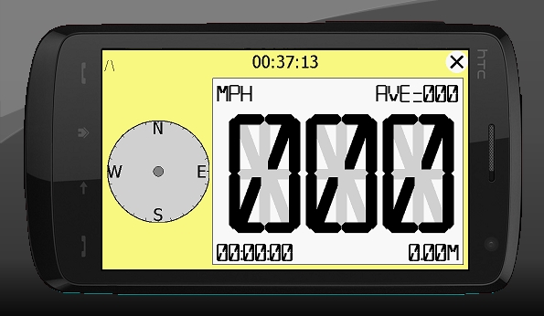
hdSpeedo is a speedometer that is driven from a GPS signal.
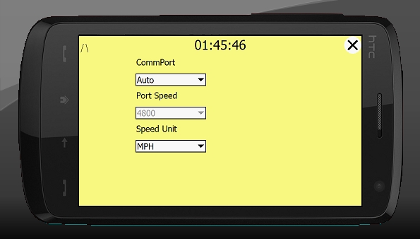
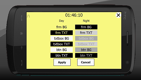
· User configurable background colours
· Day/Night colour schemes (Choose by clicking on the top status bar)
· Rotatable (Portrait or Landscape)
· Gesture enabled (Move between screens)
· Point and Track logging now available as .kml files
· satellite position location page
· Ability to flip speedo panel to allow use for a HUD
What's New in This Release:
· Journey stats saved in /My Documents/hdSpeedo
· Tidied up the /My Documents/hdSpeedo folder.
· Error logging to file
· Display of Max speed. This swaps every 15 secs with the AVG speed
Like it? Share with your friends!
If you got an error while installing Themes, Software or Games, please, read FAQ.
Supported operating systems:
Windows Mobile 2003, Windows Mobile 5.0, Windows Mobile 6 Classic, Windows Mobile 6 Professional, Windows Mobile 6.1 Classic, Windows Mobile 6.1 Professional, Windows Mobile 6.5 Professional
Similar Software:
Gippos Gippos is an application for mobile devices allowing the user to locate his or her position on the map, share the location with friends and see other users on the same map. Users can also exchange instant messages with their friends
DateGPSs DateGPSs - DateGPSs uses the GPS network to find the UTC date and time. The program shows the date and time in a 10 entry offset list. You can customize the times via decimal numbers for under 1 hour. The time offsets are saved to a file.
This program requires that you have both the 'BeanDLL.dll' file ** and ** the runtime files for Visual Basic on your PocketPC computer
Mobile Notes "Where I've been?" feature
Record track lines, points of interest(POI).
Different colors indicate different speed route.
Record text, picture and video style POI.
Record raw gps nmea data for reference and analysis.
Attach pictures to tags of geographical information
GPS Logger 2005 GPS Logger 2005 - Automatically record trip data over days or weeks. Make detailed surveys of topographical features, GIS, boundaries, street furniture, boreholes or any other element for which you wish to store location data. Plot it to CAD or any popular mapping application to produce easy to read graphical representations of your work
FON Access Points for Italy FON Access Points for Italy - FON offers you a new Points of Interest service (POIs). This allows you to download FONspots directly to your navigation device.
What does that mean? You can download a Points of Interest file directly to your navigation device
FON Access Points for Honduras FON Access Points for Honduras - FON offers you a new Points of Interest service (POIs). This allows you to download FONspots directly to your navigation device.
What does that mean? You can download a Points of Interest file directly to your navigation device
Danger! App for notification of danger on the road
GeoFence MASPware GeoFence is a GPS-based surveillance tool for Windows Mobile devices. This program loads a virtual fence (GPX/KML) and starts alerts, if the current position is out of bounds.
This program can use any kind of GPX (GPS Exchange Format) data files and can also use Google KML files. You can easily record tracks with e.g
PictureGPSings PictureGPSings - PictureGPSings can be used when you want to describe a set of pictures/videos from your camera and GPS information. Enter the text to place at the end of the images and the text will appended to the end of the images/videos taken with the GPS information.
This program requires that you have both the 'BeanDLL
FoodGoogling FoodGoogling uses the GPS on your PocketPC to find the top 50 closest local food shops sorted via GPS distance. Select the food type and tap the button to start the GPS and when you get a lock tap on it to view the list selected type of local food shops. The GPS maps and business search service is provided by Google
Other Software by developer «MrRalphMan»:
not found
Comments on hdSpeedo:
Comments not found
If you noted an error or download link is broken, please, report it via this page or use comments.