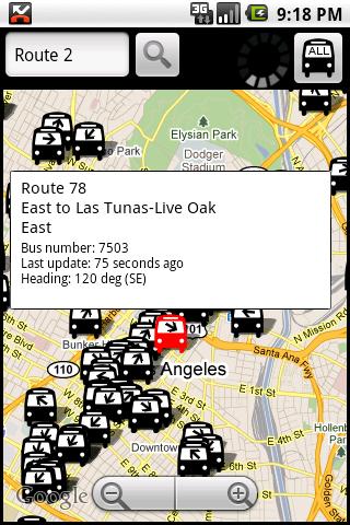
Los AngelBus - This application shows locations and predicts bus times in Los Angeles using GPS info from the Los Angeles Metro.
What's New in This Release:
· GPS now turns on when you start the app to allow quicker location lookup times. NOTE: There is also a new checkbox in the settings to disable this if you do not want it
· all stops mode added! This will show and update all bus stops around the center of the screen, not just ones on your current route. May be slow for older phones
· recently updated stops are temporarily colored green to show that they've updated
· search now searches stop titles in addition to routes
What's New in 4.01:
· updating to use new live bus schedule
What's New in 3.32:
· you can now show only a specific route in the 'more info' screen
Like it? Share with your friends!
Supported operating systems:
Google Android 1.5, Google Android 1.6, Google Android 10.x, Google Android 2.0, Google Android 2.1, Google Android 2.2, Google Android 2.3, Google Android 3.0, Google Android 3.1, Google Android 3.2, Google Android 4.0, Google Android 4.1, Google Android 4.2, Google Android 4.3, Google Android 4.4, Google Android 5.x, Google Android 6.x, Google Android 7.x, Google Android 8.x, Google Android 9.x
Similar Software:
Metro Guide Metro Guide will provide complete information about location (address with map, route, website, phone number). & Help you to find the easiest route to the destination.
Categories
agoda.com agoda.com - Smarter hotel booking just got smarter.
agoda.com
for Android - a world of hotels in the palm of your hand.
The agoda advantage. To go
Stop Alarm Stop Alarm is a GPS-based alarm for commuters which works with all public transportation systems. It tracks your position and then sets off an alarm when you are near your destination. This allows you to continue working on your smartphone without having to worry about being distracted and missing your stop, or take a nap without missing your stop
Store Hours Store Hours by HourDB is a store hours look up service for the US. It currently indexes around 320,000+ locations, which are easily searchable. So, ever wonder when the restaurant chain by your house closes? Finally you can find out. Or, if you want to find all the open locations around you at 3AM -- you can do it
Kayak Free Travel Assistant Kayak Free Travel Assistant-KAYAK connects you to the best travel search engine in the world. Find the right flight. Get the perfect hotel. If your flight is canceled, find a new one in a minute. Compare hundreds of travel sites at once
Tokyo Metro This app grants you fast acces to the last Tokyo metro map, no internet connection needed once it has been installed. Full zoom controls. Fast, light and simple
ResRobot ResRobot is the most comprehensive service for planning journeys within Sweden. The ResRobot journey planner is the most comprehensive service for planning journeys within Sweden. In a single location, you can find timetables for train, bus, plane and tram services all over the country
Yurtdisi Gezi Rehberi Yurtdisi Gezi Rehberi - Yurtdışına çıkmadan önce nereye gideceğinizi seçmenize yardımcı olacak, güncel bilgilere ulaşabileceğiniz bir uygulama
Offi - Public Transport Buddy Everything you need for mastering public transportation! • departure times (live, including delays), • nearby stations (also on a map), • direction queries and
Other Software by developer «George Schneeloch»:
UMichBusMap An Android application which shows the live positions of University of Michigan buses overlayed on Google Maps
TorontoBusMap TorontoBusMap - TorontoBusMap shows locations and predicts bus times in Toronto using GPS info from the Toronto Transit Commission.
What's New in This Release:
· GPS now turns on when you start the app to allow quicker location lookup times
BostonBusMap BostonBusMap is an application for Android phones. It uses GPS data provided by the MBTA to plot the real-time location of buses on a map.
What's New in This Release:
· GPS now turns on when you start the app to allow quicker location lookup times