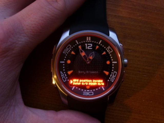
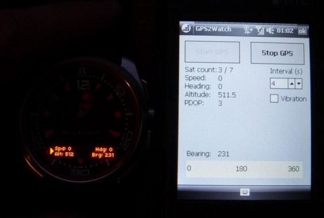
GPS2Watch - Add-on for smartWatchM that displays GPS information on supported Bluetooth watches. It simply uses smartWatchM "3rd party notifications", and connects to WM5+'s intermediate GPS driver, so no messing with COM ports. It should work with any device/GPS combination, if the GPS is external it must be set in WM's "External GPS" settings. Simply run the program, click "Start GPS", and the watch should start displaying GPS info, refreshed every 4 seconds (this seems to be the best choice to have a nearly continuous display, seeing how smartWatchM polls the text file). This results in only short blinks from the watch between screen updates.
The watch will display "GPS Position Invalid" when used sats < 3 or PDOP > 10. In normal display, the display shows Speed, alt, heading and a user settable bearing.
· GPS speed, alt, heading display
· User settable bearing
· User-definable update rate, min 4 seconds
· Watch vibration on/off
· Uses WM5+ GPS driver, so make sure "External GPS" settings are correct (DON'T touch if you use an internal GPS)
Like it? Share with your friends!
If you got an error while installing Themes, Software or Games, please, read FAQ.
Supported operating systems:
Windows Mobile 5.0, Windows Mobile 6 Classic, Windows Mobile 6 Professional, Windows Mobile 6.1 Classic, Windows Mobile 6.1 Professional, Windows Mobile 6.5 Professional
Similar Software:
FON Access Points for Palestinian Territory FON Access Points for Palestinian Territory - FON offers you a new Points of Interest service (POIs). This allows you to download FONspots directly to your navigation device.
What does that mean? You can download a Points of Interest file directly to your navigation device
myRadar myRadar is a location aware radar application that makes use of Wunderground and Accuweather US web services to show real-time, animated Radar Images of your local area regardless of where in the US you might be. This application requires myLocation services to function automatically.
The program will install to /Program Files/myRadar
MapGPSed MapGPSed - MapGPSed can be used to compose and view a list of GPS map location points and draws lines of the GPS routes. You can export the map in in street, terrain or satellite view. The map service provided by Google.com
This program requires that you have both the 'BeanDLL.dll' file ** and ** the runtime files for Visual Basic on your PocketPC computer
Woodpecker GeoScout GeoScout is designed to be the only software you need to go geocaching. You can download/import, view and manage all caches of interest. With a connection to a suitable GPS, GeoScout can also guide you to the cache waypoint(s).
GeoScout requires individual gpx files for each cache, however don''t worry if you don''t have these
TaxiGPSeds TaxiGPSeds - TaxiGPSeds can be used by a taxi driver that gets a GPS pickup. The program gets the current GPS and allows entry of the pickup GPS. Then you can view the distance and download the route map from the Google.com map service.
This program requires that you have both the 'BeanDLL.dll' file ** and ** the runtime files for Visual Basic on your PocketPC computer
GPSGoogler GPSGoogler uses the GPS on your PocketPC to find the 50 closest local businesses from 2,238 type of Yellow Pages entry sorted via GPS distance. Tap the button to start the GPS and when you get a lock tap on it to view the list of local businesses. The GPS maps and business search service is provided by Google
FasterFix FasterFix - Do you live outside the US? Are you bored of setting your gps.conf manually? The answer to all (or at least one) of your problems is FasterFix.
What's New in This Release:
· Added Germany, France and Japan
· Move to SD support
What's New in 1.0:
· Over 5000 users, no bugreports since RC3. appears to be stable
GPSTwitterer GPSTwitterer allows you to oAuth update and view Twitter contacts via GPS. You can use the GPS to find your current location and send a tweet and also track your friends via Twitter. The map service is provided by Google.com. The tweet service is provided by Twitter
SMSGPSer SMSGPSer allows you to create SMS contact number '.pgps' links and dial them via GPS distance. Select 'Start GPS' to get a GPS lock and create a new '.pgps' phone number. The program displays the distance between each GPS point and your current GPS. Tap on the link to start the built in SMS composer
RulerGPSeds RulerGPSeds is a full-featured GPS ruler with text exporter
Other Software by developer «kilrah»:
not found
Comments on GPS2Watch:
Comments not found
If you noted an error or download link is broken, please, report it via this page or use comments.
GPS2Watch is compatible with your device Airis T483 / T483L