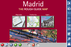
Rough Guides Map Madrid... These guides are a series of fantastic interactive maps.
Produced in conjunction with the premier travel publisher Rough Guides.
Discover and explore Madrid using full colour interactive linked maps, in this simple to use PDA version of The Rough Guides Madrid.
Find all the top tourist spots and key attractions with ease, information on the city and its sights can be quickly displayed with links to photographs and map locations. All in a superb easy to use interface.
If you''re travelling to Madrid, be sure you don''t leave home without this guide on your PDA.
The Rough Guide city maps includes:
Fully scrollable and interactive maps of the city.
Tap any location to display information and available links.
Intuitive navigation bar meaning you are never more than one click away from the information you require.
Map links allow you to directly link to other maps, photographs, or detailed views.
Categorised Find feature allowing you to quickly find any street, place of interest or station.
Categorised Information feature providing a wealth of information on the city, places of interest, etc.
1-Click Home feature, keeping the Home map always at hand.
Zoom function on all maps.
Hi Res & landscape displays supported.
Like it? Share with your friends!
If you got an error while installing Themes, Software or Games, please, read FAQ.
Supported operating systems:
Pocket PC 2002, Windows Mobile 2003, Windows Mobile 5.0, Windows Mobile 6 Classic, Windows Mobile 6 Professional, Windows Mobile 6.1 Classic, Windows Mobile 6.1 Professional, Windows Mobile 6.5 Professional
Similar Software:
TrackyPro (online GoogleMaps with GPS) TrackyPro - If you have taken your auto navigation system into the woods you probably realized that it becomes more of a paper weight than a navigation device. Without roads most cannot function. That is why you may need off-road navigation software
Travel Europe - A complete Guide, Road maps, and Phrasebook By Rick Steve Travel Europe - Rick Steves doesn't just list where to travel in Europe, he gives travelers inside information on where to stay, what to visit, and how to get there -- economically and hassle-free. With Rick Steves as their guide, travelers can delve into European culture, make friends with the locals, and experience everything Europe has to offer
Map of Milan / Italy for City Advisor Milan / Italy map for City Advisor. Includes all tube lines, all urban trains lines, all tramway lines, all bus lines and supports full timetables.
Instructions:
1. Download the map (zip file)
2. Extract the files in /CityAdvisor/maps
3. Open CityAdvisor -> Maps icon -> Menu -> Refresh
4
Tube Paris Pro (2009 Edition) Tube Paris Pro
New release with GPS support.
Tube plans all your journeys for you on the Paris metro & RER systems. It gives you the quickest routes, detailed on what trains to take and in what direction plus, service running times, fare zones, ticketing information and lots more...
Map of Rotterdam / Netherlands for City Advisor Map of Rotterdam / Netherlands for City Advisor - A Rotterdam map of Netherlands for City Advisor.
Instructions:
1. Download the map (zip file)
2. Extract the files in /CityAdvisor/maps
3. Open CityAdvisor -> Maps icon -> Menu -> Refresh
4
A-Z Birmingham Street Atlas A-Z Birmingham Street Atlas - From the publishers of the world famous A-Z street atlases comes this publication designed for a Windows® Mobile-based Pocket PC (version 2002 or later) and Pocket A-Z Viewer (included)
Travel Berlin, Germany - Illustrated Guide, Phrasebook and Maps. Travel Berlin, Germany - an illustrated city guide, phrasebook, and maps. Indulge Yourself with a personal tour guide on Your PDA. FREE General Information chapter and a map in the trial version.
Features
Fully illustrated.
Historical overviews.
Interesting facts.
Street Map, Transportation Maps, and more.
Museums hours and tickets info
Travel Miami Beach and Miami - city guide and maps Travel Miami is a comprehensive travel guide to Miami. Indulge Yourself with a personal tour guide on Your PDA. FREE General Information chapter in the trial version.
Features
Fully illustrated.
Historical overviews.
Interesting facts.
City Maps.
Museums address, telephone, hours and admission information.
Easy to navigate
TwitsnapsMaps TwitsnapsMaps uses the GPS on your PocketPC to find your current latitude/longitude/speed and altitude and allows you to upload your position via map to Twitter.com. You can customize the maps zoom, and type via the 'Options' in the toolbar. The maps service is provided by Google.com. The map/Twitter storage is from TwitSnaps
TerraTrack Recorder 7 Route guidance in 3D view, makes navigation processes very simple and intuitive
Other Software by developer «Visual IT»:
Tube 2 Barcelona Pro (Palm OS) Tube 2 Barcelona Pro (Palm OS) - This map package for Tube 2 consists of a fully scrollable detailed map of the Barcelona metro & rail system and linked street maps of central Barcelona.
Plan journeys on the metro system, list details of the quickest routes and see a superb animated display of your journey tracking around the system map
Tube Athens (Palm OS) Tube Athens (Palm OS) - An award winning and highly acclaimed Palm OS application that guides you around the metro & light rail system of Athens. An essential addition to your Palm device for locals and tourists alike.
Tube's features include:
A detailed clear colour (or grey scale) map of the transport system fully scrollable.
Quick find station utility
Tube Vienna (iPhone) Tube Vienna (iPhone) is a superb interactive guide to the Vienna Metro (U-Bahn) and Vienna Tram (StrassenBahn) systems.
With no need for an internet connection Tube Vienna will always be available to display a clear and detailed view of the city transport systems, plus list and animate the optimum route for all your journeys
London Bus London Bus - The new Zuti London Bus map has finally arrived, making it easy to travel by bus anywhere in central London. This clear and colourful map covers a detailed street level area of 6 miles by 4 miles and includes over 1300 bus stops and 189 bus routes
New York Subway by Zuti New York Subway by Zuti - The "New York Subway" application is a superb geographically based map and route planner for the New York public transport systems
Tube 2 Engine Pocket PC Tube 2 Engine - Transform your PDA into a fully scrollable detailed map of one of the worlds subway or metro systems.
See your journeys come alive with a superb animated display.
Save hours by automatically having the quickest routes to hand, with all the details you need including line changes, platform directions and accurate journey times
GB Major Road Atlas (UIQ) GB Major Road Atlas (UIQ) - This map package is an essential addition to your Tube 2 maps if you drive in and around Great Britain.
This reference map gives you a clear view of all the major roads in the whole of Great Britain, you can use the quick find feature to locate any of the 30,000 + GB towns and villages in the database
Edinburgh Mini A-Z Edinburgh Mini A-Z - This street map of Edinburgh covers an area extending to Cramond, Granton, Leith, Portobello, Musselburgh, Whitecraig, Dalkeith, Bonnyrigg (part), Loanhead, Fairmilehead, Juniper Green, Currie, Balerno, and Edinburgh Airport.
Major buildings are colour-coded to indicate places of interest and other buildings that are open to the public
Tube 2 Paris Pro (Palm OS) Tube 2 Paris Pro (Palm OS) - This map package for Tube 2 consists of a fully scrollable detailed map of the Paris metro & RER system and linked high quality street maps of central Paris.
Plan journeys on the metro & RER system, list details of the quickest routes and see a superb animated display of your journey tracking around the system map
Tube Tyne & Wear (UIQ) Tube Tyne & Wear (UIQ) - An award winning and highly acclaimed application that guides you around the metro system of Tyne & Wear.
An essential addition to your Sony Ericsson P800 / P900 / P910 if you travel in or around this city
· A detailed clear colour map of the Tyne & Wear metro system fully scrollable.
· Quick find station utility


 Hi Res & landscape displays supported.
 ")


")


")
")
")


")

")
")