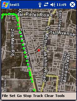
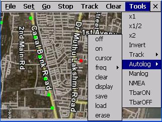
Movmap is a simple freeware GPS tracking program meant for WinCE/PocketPC machines. It can run on PNAs that use WinCE 4.2 .NET Core OS. See the movmap.txt file for details. Source codes for the program are also available.
The application is now called Movmap3D. It can load SRTM 90m elevation data files and display maps in 3D!
Like it? Share with your friends!
If you got an error while installing Themes, Software or Games, please, read FAQ.
Supported operating systems:
Pocket PC 2002, Windows Mobile 2003, Windows Mobile 5.0
FindMe by SMS FindMe by SMS - This one works in background and does not alert user that their location is queried. Restarts automatically if phone is power cycled
BikeDashboard BikeDashboard- This application provides training assistance (through graphs and stats) + navigation help (with moving maps and GPX file import & export) for mountainbike and roadbike enthusiasts.
BikeDashboard Features:
* Keep a track of their achievements:
o Where they have been.
o How long.
o How fast
FON Access Points for Jersey FON Access Points for Jersey - FON offers you a new Points of Interest service (POIs). This allows you to download FONspots directly to your navigation device.
What does that mean? You can download a Points of Interest file directly to your navigation device
ContactGPSer ContactGPSer allows you to create and view phone/SMS/email contact number '.cgps' links and Dial/SMS or Email the contacts via GPS distance. Select 'Start GPS' to get a GPS lock and create a new '.pgps' contact link. The program displays the distance between each contact via your current GPS
NoniGPSPlot Pocket PC NoniGPSPlot allows you to locate your position in relation with other GPS points, to see the journey you have traveled.
You can find back your place at harbour after a trip on boat, the starting point of an excursion or locate your car in a huge car park, A place of which you know the location, To see the excursion you made, Speed trap alert or lots of other things..
AgMapper AgMapper - Create maps using your Windows Mobile device. Measure lengths and view areas without the desktop PC.
AgMapper makes it easy to map what ever you like and share it with other software packages by using the very common shape file format (.shp) to store your mapping data.
Load images onto your map created using the FREE AgMapper Image Converter
BackCountry Navigator BackCountry Navigator is fun-filled navigation software for the outdoor adventurer. Use it in a variety of outdoor adventures, from kayak touring to geocaching. This is a summary of what you can do with the product.
BackCountry uses free topo and aerial maps for the United States, downloaded directly from Terraserver-USA
GPS Tuner Atlas Full Version with Full Europe Basic Map Content GPS Tuner Atlas Full Version with Full Europe Basic Map Content is designed specifically for off-road use: its large buttons, selectable tool window size, 6 different types of Compass views and the built-in Tele Atlas map makes it extremely user-friendly and reliable
quoox|TRACKER quoox|TRACKER - quoox gps tracker is a free service to live-track any kind of things using gps technology. The only thing needed is a device, which uploads its current gps data to quoox tracker service periodically.
This service is completely free for private use and easy to use. Just register a tracker id, simple as that
Comments on Movmap GPS:
Hosni:
Merci
Date: 14 Jul 22
If you noted an error or download link is broken, please, report it via this page or use comments.
Attention! Movmap GPS may be not compatible with your device Airis T610 / T620


")


