GPS4PPC is an open source application, written with Basic4ppc that includes a set of tools for navigation and GPS data.
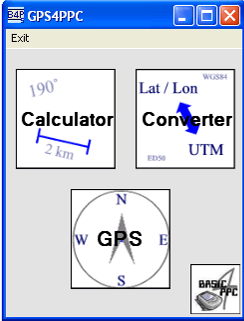
GPS4PPC supports:
- Converting coordinates between UTM and Lat / Lon.
- Converting coordinates in different datums.
- Calculating the distance and course between two coordinates.
- Show GPS data.
- Animated compass.
- Built-in numpad for fast and easy input.
Like it? Share with your friends!
If you got an error while installing Themes, Software or Games, please, read FAQ.
Supported operating systems:
Windows Mobile 5.0, Windows Mobile 6 Classic, Windows Mobile 6 Professional, Windows Mobile 6.1 Classic, Windows Mobile 6.1 Professional, Windows Mobile 6.5 Professional
Similar Software:
FON Access Points for Canada FON Access Points for Canada - FON offers you a new Points of Interest service (POIs). This allows you to download FONspots directly to your navigation device.
What does that mean? You can download a Points of Interest file directly to your navigation device
Sanoodi Sanoodi is one of the world's leading community platforms for runners, joggers, walkers, cyclists and people who enjoy any of the 30 different outdoor activities that we support. People from all over the world are sharing their adventures via our website or SMap our free to use range of applications for GPS equipped mobile phones. Sanoodi
PouchHiker Drivers see hitchhikers and carpoolers and their destination. Hitchhikers/carpoolers can make themselves visible to drivers
FON Access Points for Tunisia FON Access Points for Tunisia - FON offers you a new Points of Interest service (POIs). This allows you to download FONspots directly to your navigation device.
What does that mean? You can download a Points of Interest file directly to your navigation device
CyberTracker 3 CyberTracker 3 - Capture data in the field using our unique icon-based user interface and a GPS for georeferencing. Analysis of the results can be done either in CyberTracker or exported to a third party program. Requires PocketPC 2002/2003/WM5+ or Palm 3 and higher
GPS Mod Driver GPS Mod Driver - This Driver installs between your GPS application and the GPSID driver that reads the hardware GPS data. Lag is compensated, by guessing your position 'some number' of milliseconds in the future, current course and speed changes are included in the guess
FON Access Points for Latvia FON Access Points for Latvia - FON offers you a new Points of Interest service (POIs). This allows you to download FONspots directly to your navigation device.
What does that mean? You can download a Points of Interest file directly to your navigation device
VirtualGPS Virtual GPS is a free, small utility, which fully emulates GPS module and returns your location (by using cellular towers).
Accuracy of coordinates is about 200m in urban area and up to 5km in countryside. Screenshots are explaining how to use VirtualGPS with navigation software (e.g. "Google Maps")
EagleEye PDA Tracking System for HW6500/HW6900 Series EagleEye PDA Tracking System for HW6500/HW6900 Series - We at Targex Corp. have been in the vehicle tracking business for over 10 years, researching and offering products that are advanced and extremely reliable
Loki Mobile Loki Mobile-Loki Mobile allows you to locate yourself and search locally on any WiFi-enabled device.
Loki is the first application in history that automatically uses your exact physical location to harness the power of the Internet
Comments on GPS4PPC:
Comments not found
If you noted an error or download link is broken, please, report it via this page or use comments.
Attention! GPS4PPC may be not compatible with your device Airis T610 / T620