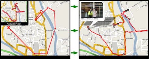
Sunset GPS Logger-allows you to capture your activities (walking, running, cycling, snowboarding, hiking trails .etc) for later visualisation on Google maps. Combined with your existing digital camera it becomes an indispensable tool to simplify the process of geo-tagging those precious photos and memories.
Installation Instructions:
1) Install the application by copying the cab file to your device via ActiveSync then running it on your device.
2) Ensure you have paired up a GPS receiver with your device and have assigned 'com7' as the outgoing devices com, for devices with a built in GPS ensure this is the GPS 'Hardware' port not programme port.
3) To start GPS logging select Menu -> Start GPS Trail.
4) To stop logging select Menu - > Stop GPS Trail.
5) You can find all your GPS logs in the following device directory 'Storage CardGPSLogs'.
6) International locale issue: If you live outside the UK to ensure GPX format compatibility please set you normal number format to the following (English: '.' For decimal and ',' as digit grouping).
Additional Notes: To GPS tag your photos: use the gpx log files in combination with Microsoft's WWMX Location Stamper or DGManager.NET Nb. For the best results ensure that BOTH your Mobile device and Digital cameras date/time settings are identical, as both rely heavily on date/time in GPS tagging your photos.
Like it? Share with your friends!
If you got an error while installing Themes, Software or Games, please, read FAQ.
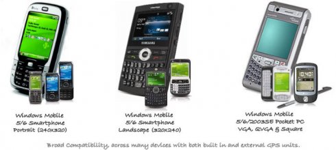
Supported operating systems:
Windows Mobile 5.0, Windows Mobile 6 Classic, Windows Mobile 6 Professional, Windows Mobile 6.1 Classic, Windows Mobile 6.1 Professional, Windows Mobile 6.5 Professional
Similar Software:
GPSGoogler GPSGoogler uses the GPS on your PocketPC to find the 50 closest local businesses from 2,238 type of Yellow Pages entry sorted via GPS distance. Tap the button to start the GPS and when you get a lock tap on it to view the list of local businesses. The GPS maps and business search service is provided by Google
KM GPS Autodetect KM GPS Autodetect - Tool search for GPS connected to PDA. Program needs 2-3 minutes to try all ports and speeds on device
FON Access Points for Algeria FON Access Points for Algeria - FON offers you a new Points of Interest service (POIs). This allows you to download FONspots directly to your navigation device.
What does that mean? You can download a Points of Interest file directly to your navigation device
Wenak Wenak - Mobisoft Wenak lets you share your location with your friends, family members, co-workers and loved ones by making it easy to tell them where you are and see each other on the map. Wenak lets you share your location in the background, even when the app is closed
PoliceGPSings PoliceGPSings - PoliceGPSings can be used by a Police officer to create dated GPS POI based note logs. For each GPS area you can create a log of reports from the area. The program uses the GPS on the PocketPC to find the distance of each GPS POI point and you can view or download the map the points on Google.com map service
FON Access Points for French Polynesia FON Access Points for French Polynesia - FON offers you a new Points of Interest service (POIs). This allows you to download FONspots directly to your navigation device.
What does that mean? You can download a Points of Interest file directly to your navigation device
SIGLOG SIGLOG - A Windows Mobile application that logs latitude, longitude, signal strength, mobile country code, mobile network code, location area code, CellID.
Written in Win32 C++ it's lean, mean, rather basic, but it does the job. It requires a phone with GPS, as it calls the Microsoft intermediate GPS driver
CoffeeGoogler CoffeeGoogler uses the GPS on your PocketPC to find the 50 closest coffee shops sorted via GPS distance. Tap the button to start the GPS and when you get a lock tap on it to view the list of local coffee shops. You can also dial the store. The GPS maps and coffee search service is provided by Google
Danger! App for notification of danger on the road
Comments on Sunset GPS Logger:
Comments not found
If you noted an error or download link is broken, please, report it via this page or use comments.
Sunset GPS Logger is compatible with your device Airis T610 / T620