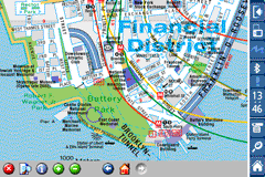
Rough Guides Map New York City... These guides are a series of fantastic interactive maps.
Produced in conjunction with the premier travel publisher Rough Guides.
Discover and explore New York City using full colour interactive linked maps, in this simple to use PDA version of The Rough Guides New York City.
Find all the top tourist spots and key attractions with ease, information on the city and its sights can be quickly displayed with links to photographs and map locations. All in a superb easy to use interface.
If you''re travelling to New York City, be sure you don''t leave home without this guide on your PDA.
The Rough Guide city maps includes:
Fully scrollable and interactive maps of the city.
Tap any location to display information and available links.
Intuitive navigation bar meaning you are never more than one click away from the information you require.
Map links allow you to directly link to other maps, photographs, or detailed views.
Categorised Find feature allowing you to quickly find any street, place of interest or station.
Categorised Information feature providing a wealth of information on the city, places of interest, etc.
1-Click Home feature, keeping the Home map always at hand.
Zoom function on all maps.
Special Offer Only $20.00
Hi Res & landscape displays supported.
Like it? Share with your friends!
If you got an error while installing Themes, Software or Games, please, read FAQ.
Supported operating systems:
Pocket PC 2002, Windows Mobile 2003, Windows Mobile 5.0, Windows Mobile 6 Classic, Windows Mobile 6 Professional, Windows Mobile 6.1 Classic, Windows Mobile 6.1 Professional, Windows Mobile 6.5 Professional
amAze (Sony Ericsson) AmAze is a first of its kind free navigation and local search service. It is free to download and use and it contains wide coverage of maps including aerial photo in Europe, North America, Australia and parts of Asia and Africa
Moscow Map Moscow Map - Full map solution for Pocket PC
View map:Display map,select objects,zoom,pan,...
Search: Search street,location,..by name
Shortest path: Show shortest path and total distance.
GPS: Connect to GPS device by bluetooth,go to location in map
Map of Washington (US State) Map of Washington (US State) - A map of the Washington by VITO Technology. Good for intercity travels with SmartMap.
SmartMap is a mobile device application which uses vector and raster maps. It is compatible with any NMEA protocol GPS receiver (Compact Flash socket, serial port, BlueTooth or sleeve)
LittleWays LittleWays - LittleWays is a simple route calculator for subways, tramways, bus lines and rapid train railways.
Using LittleWays you can provide start and end station and LittleWays will calculate all possible ways and displays them in a list. It's your choice which way you use. After selecting a route it will be displayed as a bold red line
A-Z Mini Birmingham Street Atlas A-Z Mini Birmingham Street Atlas - From the publishers of London''s best selling paperback street atlas comes this publication designed for a Windows® Mobile-based Pocket PC (version 2002 or later) and Pocket A-Z Viewer (included)
ReliRescue GPS ReliRescue ("Reli Search & Rescue") enables your Windows Mobile Phone to broadcast your location to designated partners (over SMS or email). Your location is obtained using Integrated or external (Bluetooth) GPS connected to your device.
This utility also enables any Windows Mobile platform to feed the broadcasted waypoints to track and locate the sender
PrettyEarth PrettyEarth
View maps of Earth with PrettyEarth! See current day and night regions, learn geography by taking the quiz, enjoy relief elevation surfaces and measure distances between locations
DeliveriesDirections DeliveriesDirections - This program allows you to set your home address/city/country. Then enter a local address and tap the button to view a route from or to your home location via Goggle.com map service.
This program requires that you have both the 'BeanDLL.dll' file ** and ** the runtime files for Visual Basic on your PocketPC computer
Other Software by developer «Visual IT»:
Beijing Subway for iPad by Zuti Beijing Subway for iPad by Zuti - Beijing Metro map makes it easy to travel in and around the city using the Beijing metro system and also includes the S2 rail line to the Great Wall at Badaling
Tube 2 New York Geo (UIQ3) Tube 2 New York Geo (UIQ3) - This superb map package for Tube 2 is the ideal map for anyone who needs to get around New York City using the MTA subway system and would like to know just exactly where they are.
The map geographically accurately locates all of Manhattans central stations, overlaid onto a street map
Tube 2 Madrid (UIQ) Tube 2 Madrid (UIQ) - This map package for Tube 2 consists of a fully scrollable detailed map of the Madrid metro system.
Plan journeys on this system, list details of the quickest routes and see a superb animated display of your journey tracking around the system map
Tube 2 Brussels (UIQ) Tube 2 Brussels (UIQ) - This map package for Tube 2 consists of a fully scrollable detailed map of the Brussels tram, metro & bus system.
Plan journeys on these systems, list details of the quickest routes and see a superb animated display of your journey tracking around the system map
Tube 2 Paris Pro (UIQ) Tube 2 Paris Pro (UIQ) - This map package for Tube 2 consists of a fully scrollable detailed map of the Paris metro & RER system and linked high quality street maps of central Paris.
Plan journeys on the metro & RER system, list details of the quickest routes and see a superb animated display of your journey tracking around the system map
Rough Guides Map Barcelona Rough Guides Map Barcelona... These guides are a series of fantastic interactive maps.
Produced in conjunction with the premier travel publisher Rough Guides.
Discover and explore Barcelona using full colour interactive linked maps, in this simple to use PDA version of The Rough Guides Barcelona
London Master A-Z for iPad London Master A-Z for iPad - This clear and colourful high quality map covers the same area as the market leading A-Z "Master Atlas of Greater London Street Atlas". The familiar look makes this by far the easiest London iPad map to use. The map is drawn by real cartographers with the detailed care and the human touch of emphasis and colour that A-Z are famous for
Rough Guides Map Amsterdam Rough Guides Map Amsterdam... These guides are a series of fantastic interactive maps.
Produced in conjunction with the premier travel publisher Rough Guides.
Discover and explore Amsterdam using full colour interactive linked maps, in this simple to use PDA version of The Rough Guides Amsterdam
London Bus by Zuti London Bus by Zuti - The new Zuti London Bus map has finally arrived, making it easy to travel by bus anywhere in central London. This clear and colourful map covers a detailed street level area of 6 miles by 4 miles and includes over 1300 bus stops and 189 bus routes
London Bus Free London Bus Free - The new Zuti London Bus map has finally arrived, making it easy to travel by bus anywhere in central London. This clear and colourful map covers a detailed street level area of 6 miles by 4 miles and includes over 1300 bus stops and 189 bus routes


 Hi Res & landscape displays supported.
 ![USA-CO [Colorado] Map for EagleEye PDA Tracking System](https://static.mobyware.org/data/images/def_program_reduced.png "USA-CO [Colorado] Map for EagleEye PDA Tracking System")
")
")


")
")
")
")


