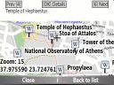
Bluemapia Mobile - View Maps, Search places and geotagged Wikipedia articles, GPS. Mobile Application for bluemapia, the new Web & Mobile Social Mapping for Boaters
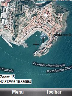
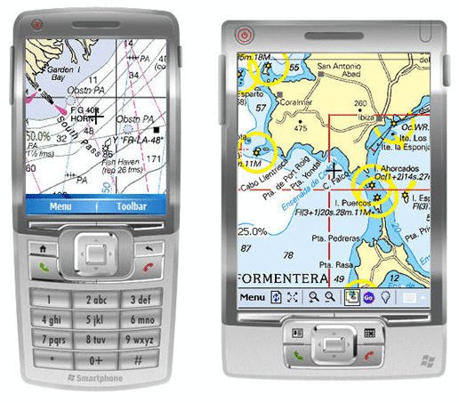
- View Maps (OpenStreetMap and other web map servers)
- Support BSB/NOAA Charts and raster, calibrated charts
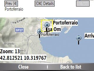
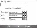
- Search places by name and bluemapia content from the web site
- View geotagged Wikipedia articles on the map
- Use a GPS to display your position on the map and set a terget destination
- Create tracks (gpx file)
- Shoot and upload photos and text to bluemapia for community sharing
Like it? Share with your friends!
If you got an error while installing Themes, Software or Games, please, read FAQ.
Supported operating systems:
Windows Mobile 2003, Windows Mobile 5.0, Windows Mobile 6 Classic, Windows Mobile 6 Professional, Windows Mobile 6.1 Classic, Windows Mobile 6.1 Professional, Windows Mobile 6.5 Professional
Similar Software:
SmsGPSerer SmsGPSerer - SmsGPSerer updates a preset contact of your GPS location via a SMS with a Google.com mobile map link (and text also if you enter any). Tap the button to get a GPS lock. Once you have a lock enter the update text if any and tap the button to SMS the contact your GPS location with a Google.com maps mobile link
SIGLOG SIGLOG - A Windows Mobile application that logs latitude, longitude, signal strength, mobile country code, mobile network code, location area code, CellID.
Written in Win32 C++ it's lean, mean, rather basic, but it does the job. It requires a phone with GPS, as it calls the Microsoft intermediate GPS driver
EmailGPSeds EmailGPSeds - EmailGPSeds allows you to build email lists and update a person or all of the people on the list your current GPS with a Google.com map as an attachment. You can send the alert to just one email contact or all on the list. The email has a URL of your GPS from the Google.com.
This program requires that you have both the 'BeanDLL
Medical Emergency BOT With only one touch of your mobile device,
you send Emergency Alert, with your current localization and personal data.
This program has simply interface, and it's easy, intuitive in using.
After you set it correctly, you will not do too much.
Just one touch when necessary
MyGPS_PDA MyGPS_PDA - MyGPS_PDA is a light MyGPS version for PocketPC systems. It reads the NMEA sentences coming from a GPS antenna connected to the PocketPC and shows your position on a MyGPS calibrated map. The program can also store on a file the track log together with specific waypoints created by the user
SMSGPSer SMSGPSer allows you to create SMS contact number '.pgps' links and dial them via GPS distance. Select 'Start GPS' to get a GPS lock and create a new '.pgps' phone number. The program displays the distance between each GPS point and your current GPS. Tap on the link to start the built in SMS composer
FON Access Points for Cape Verde FON Access Points for Cape Verde - FON offers you a new Points of Interest service (POIs). This allows you to download FONspots directly to your navigation device.
What does that mean? You can download a Points of Interest file directly to your navigation device
TrakPal PitStop TrakPal PitStop - Analyse your performance using NMEA compliant GPS data recorded on your Pocket PC - the perfect complement to your GPS navigation software.
Compare data from different runs to find where those important seconds were lost, whether on the track, training, commuting or just for fun
GPSPOIer GPSPOIer can be used to create GPS tagged POI points with custom names
SpeedTracker SpeedTracker - Designed and tested by an experiment Marathoner, SpeedTracker is dedicated to on-road and off-road Sport practice.
Directly available from your finger tip, Cycler, Runner, Roller, ... find a set of selected options to plan,control and manage workout sessions
Other Software by developer «Bluemapia»:
not found
Comments on Bluemapia Mobile:
Comments not found
If you noted an error or download link is broken, please, report it via this page or use comments.
Bluemapia Mobile is compatible with your device Airo A25