You don't know where you parked your car anymore? Have you ever wondered how far your are away from home and in what direction it is? GpsSpot from Cradle Software shows you in what direction and how far a previously saved spot is.
Using GpsSpot you can easily save any location and using the build-in or attached GPS device the application will show you at what distance and in what direction the saved spot is. For your better recognition of the target you can also save an image with every spot. Without any difficulties you will find every saved spot again, like your parking space, your bicycle in front of yesterdays bar, the next cash machine or bus stop.
Finger-friendly handling
The application's intuitive user interface can be comfortable operated with your finger.
Your current location can be added with just three finger taps.
Picture support
You can take a picture with the camera of your device or select an existing image to assign it to your saved spot.
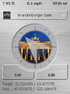
Display
The application shows the distance to the selected spot, the current altitude and the current speed. As basic unit meters or miles/feet can be selected.
High contrast mode
You can activate the "high contrast mode" for a good perceptibility of the direction arrow even on bright day light.
Support
A detailed help file is included in the application, which thanks to the intuitive user interface is rarely needed.
Of course we always provide support by eMail if you have any problems or questions.
Multilingual
The following languages are included with the application:
English, German, Turkish
Windows Mobile 5.x and 6.x
The application runs on every Windows Mobile Professional device (with touchscreen and Windows Mobile 5.0 and up) and supports all existing screen resolutions and alignments like portrait, landscape or quadratic displays.
In addition only a build-in or attached GPS device is needed.
Certified by Microsoft
The application is available at the Windows Mobile Marketplace and therefore certified by Microsoft through multiple tests. That way a good stability and Windows Mobile compatibility is guaranteed.
Free download
Download the free trial version now (the trial version does not allow to add any new spots - hence it is only possible to get the distance and direction to the preset locations).
If you like the application you can buy a registration code and change the already installed program into a full version.
Like it? Share with your friends!
If you got an error while installing Themes, Software or Games, please, read FAQ.
Supported operating systems:
Windows Mobile 5.0, Windows Mobile 6 Classic, Windows Mobile 6 Professional, Windows Mobile 6.1 Classic, Windows Mobile 6.1 Professional, Windows Mobile 6.5 Professional
Similar Software:
FON Access Points for Costa Rica FON Access Points for Costa Rica - FON offers you a new Points of Interest service (POIs). This allows you to download FONspots directly to your navigation device.
What does that mean? You can download a Points of Interest file directly to your navigation device
Navigation BE-ON-ROAD UK and Eire Q2/2011 Navigation BE-ON-ROAD UK and Eire Q2/2011 - The new major version of be-on-road presents new features and is based on new platform which brings high level of reliability, portability and speed on almost any kind of device. The new be-on-road brings high value voice guided door-to-door navigation
MapFingerer MapFingerer - MapFingerer allows you use the GPS on your device or custom GPS values to download maps from Google.com and keeps them in a finger friendly database. You can make multiple pages for the maps. Tap on the map to button to view it.
This program requires that you have both the 'BeanDLL
FON Access Points for United Kingdom FON Access Points for United Kingdom - FON offers you a new Points of Interest service (POIs). This allows you to download FONspots directly to your navigation device.
What does that mean? You can download a Points of Interest file directly to your navigation device
ExcelGPSed ExcelGPSed - ExcelGPSed allows you to create and view Pocket Excel files based on your GPS. When you create a new Pocket Excel file then the GPS location is appended to the end of the file. You can explore the Excel files via distance of your current GPS.
This program requires that you have both the 'BeanDLL
GPSed Pocket PC GPSed - Record GPS tracks from your mobile and trace them on a map.
Record tracks of your trips anywhere on the Earth from your mobile device. Tracks are traced on Google Maps and stored in an online archive. All you need to start tracking is a mobile device with the internal or external GPS receiver
GPS Toggle GPS Toggle 1.9 is a today screen plugin for Windows Mobile. It has been designed specifically for the HTC Titan, but should work on most other Windows Mobile phones that have a need for this type of application.
BAF GPS Toggle is written in native code (not .NET), and uses very little memory
ppc PhotoGeoTag ppc PhotoGeoTag - Take pictures with your mobile phone and incorporate the data of the geographical location. The application allows you to include in the photographs, data from the GPS receiver, along with a brief note. If you know the coordinates, not having the GPS receiver, you can also handwrite geographic data
GPS Speedometer GPS Speedometer displays an attractive dash with both digital and analog display using GPS
WM MiniGPS WMMiniGPS is a Windows Mobile 5/6 software which gets your GPS data in a really simple gui, showing you latitude, longitude, laltitude and speed.
It can log all to file and it can export your paths to Google Earth's kml format, letting you to see where you've been, with different time intervals
Other Software by developer «Cradle Software»:
CradleAlarm CradleAlarm
CradleAlarm supersedes the poorly featured alarm clock of Windows Mobile. With this application you can set multiple alarms, that provide a large number of settings to let you start your day as pleasant as possible, to remind you of an appointment or many more