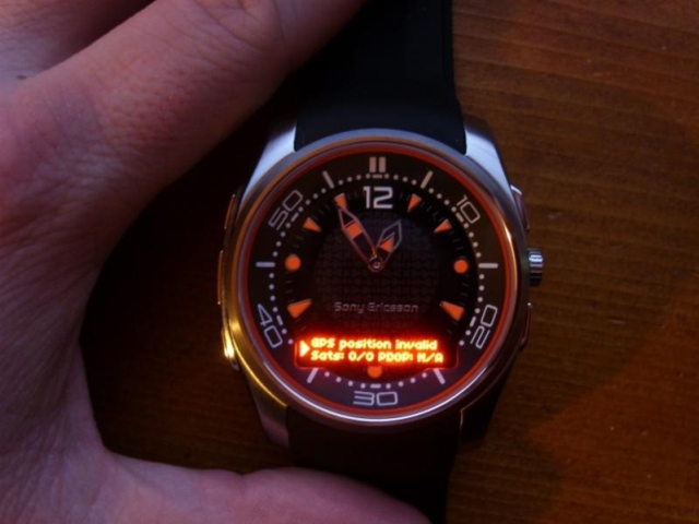
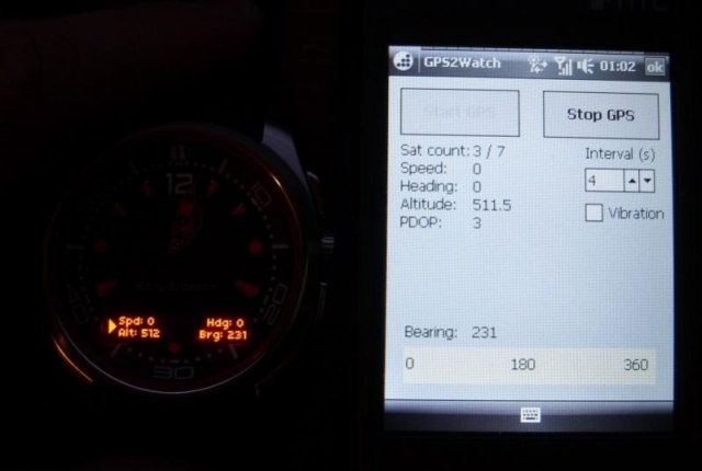
GPS2Watch - Add-on for smartWatchM that displays GPS information on supported Bluetooth watches. It simply uses smartWatchM "3rd party notifications", and connects to WM5+'s intermediate GPS driver, so no messing with COM ports. It should work with any device/GPS combination, if the GPS is external it must be set in WM's "External GPS" settings. Simply run the program, click "Start GPS", and the watch should start displaying GPS info, refreshed every 4 seconds (this seems to be the best choice to have a nearly continuous display, seeing how smartWatchM polls the text file). This results in only short blinks from the watch between screen updates.
The watch will display "GPS Position Invalid" when used sats < 3 or PDOP > 10. In normal display, the display shows Speed, alt, heading and a user settable bearing.
· GPS speed, alt, heading display
· User settable bearing
· User-definable update rate, min 4 seconds
· Watch vibration on/off
· Uses WM5+ GPS driver, so make sure "External GPS" settings are correct (DON'T touch if you use an internal GPS)
Like it? Share with your friends!
If you got an error while installing Themes, Software or Games, please, read FAQ.
Supported operating systems:
Windows Mobile 5.0, Windows Mobile 6 Classic, Windows Mobile 6 Professional, Windows Mobile 6.1 Classic, Windows Mobile 6.1 Professional, Windows Mobile 6.5 Professional
Similar Software:
PDA Navigation PDA Navigation - Simple navigation tool for Pocket PCs with GPS support.
· compass rose
· GPX tracking
· sun rise and set calculation
· export to LOC, GPX, KML
· import from GPX and LOC
What's New in This Release:
· Changed a lot of small things and corrected some errors
BackCountry Navigator BackCountry Navigator is fun-filled navigation software for the outdoor adventurer. Use it in a variety of outdoor adventures, from kayak touring to geocaching. This is a summary of what you can do with the product.
BackCountry uses free topo and aerial maps for the United States, downloaded directly from Terraserver-USA
TrackMyRun TrackMyRun is a simple GPS Run/Walk tracking application for Windows Mobile
GPSAltimeterer GPSAltimeterer uses the GPS on your PocketPC to find your altitude. You can view in Meters or Feet. This can be used on a plane that does not allow full GPS. Start the program to find your height via GPS on it. NOTE: Make sure you are allowed to use this program before starting the application
FON Access Points for Nicaragua FON Access Points for Nicaragua - FON offers you a new Points of Interest service (POIs). This allows you to download FONspots directly to your navigation device.
What does that mean? You can download a Points of Interest file directly to your navigation device
PMWGPSTracking PMWGPSTracking allows you to plot your trip in a file (. KML).
The trace files can then be viewed and compared with Google Earth.
For each track you can define intermediate time (time stamp).
For each lap, the program calculates the duration, average speed and distance.
The trace files can be sent at regular intervals on an FTP server or an email address
DocumentGPSeds DocumentGPSeds - DocumentGPSeds is a full-featured Pocket Word GPS editor/viewer. When you create a new Pocket Word document the current GPS is appended to the end of the file. You can view the files and edit them or edit the file and update it with your new GPS location.
This program requires that you have both the 'BeanDLL
LocBrowser Basic Edition LocBrowser Basic Edition - The LocBrowser Basic Edition assists mobile people in finding their route. It is especially well suited for traveling or outdoor activities like hiking or cycling. The LocBrowser Basic Edition is a comfortable and flexible viewer for digital maps. Additionally, it supports real-time navigation - when combined with a GPS receiver
G-Watch G-Watch is a stop watch which supports GPS devices. It keeps track of your distance, speed and altitude. G-Watch is a tool which combines following features: stopwatch, countdown timer and geocaching
FON Access Points for South Africa FON Access Points for South Africa - FON offers you a new Points of Interest service (POIs). This allows you to download FONspots directly to your navigation device.
What does that mean? You can download a Points of Interest file directly to your navigation device
Other Software by developer «kilrah»:
not found
Comments on GPS2Watch:
Comments not found
If you noted an error or download link is broken, please, report it via this page or use comments.