GPSToday-GeoTerrestrial GPSToday now brings an unbeatable combination of location features to your mobile device.
Driving/Walking directions in many countries, with traffic-optimization option.
Log file plotting on map and animated "playback". Also, the geologger will now never clip corners, and will perfectly follow loopy highway ramps. You can now also upload your log-files to the desktop website.(full-featured log-editing on the desktop coming soon)
Location Tracking and sharing (GeoLocation). Track your location history online for your own private use, or share with friends/family. The power-saving ability of GPSToday means you can leave it on indefinitely without worrying about the battery.
Easily and privately (or publicly) share points-of-interest, pictures, messages with like-minded folks (GeoGroups). eg. Track or update swine-flu locations, right from your phone. The possibilities are endless.
'Slideshow' through all your address-book contacts on the map, or through driving directions, or local search results, or all friends' mobile locations
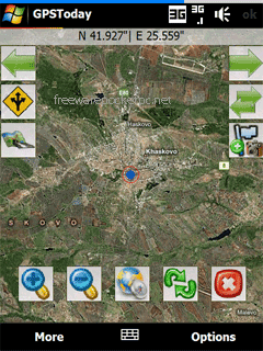
Satellite,Hybrid map views, and many more enhancements for ease of use.
Nearly worldwide support for many features that were previously US only.
Essentially the works, all in a still small package. More features are listed below the screenshots.
This software will not work on OS older than Windows Mobile 5.0 versions, or on any non-touchscreen smartphone. Data plan is recommended for online map features, but not necessary for offline features like geologging or geotagging. An Integrated GPS is advisable (but not mandatory) to fully enjoy the software.
Like it? Share with your friends!
If you got an error while installing Themes, Software or Games, please, read FAQ.
Supported operating systems:
Windows Mobile 5.0, Windows Mobile 6 Classic, Windows Mobile 6 Professional, Windows Mobile 6.1 Classic
Similar Software:
SmartCaddie Pro SmartCaddie Pro with GPS
Thousands of courses, if your course is not there we will simply add it for you
12 players or more, special versions are available for leagues.
Includes enrolment for one user in the Nova Golf Internet Network (NGIN) providing further features and functions
TwitsnapsMaps TwitsnapsMaps uses the GPS on your PocketPC to find your current latitude/longitude/speed and altitude and allows you to upload your position via map to Twitter.com. You can customize the maps zoom, and type via the 'Options' in the toolbar. The maps service is provided by Google.com. The map/Twitter storage is from TwitSnaps
Travel Tokyo, Japan - illustrated guide, phrasebook, and maps. FREE general info, maps and more Travel Tokyo, Japan - illustrated guide, phrasebook, and maps. FREE general info, maps and more - An illustrated travel guide, phrasebook, and maps. Indulge Yourself with a personal tour guide on Your PDA. FREE General Information, basic phrasebook, and a map in the trial version.
Features
Fully illustrated.
Historical overviews
TwitterGPSer TwitterGPSer uses the GPS on your PocketPC to find your current latitude/longitude/speed and allows you to update Twitter.com. Tap the button to get the GPS lock and when the program gets the lock it will create a Tweet with a Google.com map link. This service is provided by Twitter
MapGPSeds MapGPSeds - MapGPSeds is a full-featured GPS map downloader with GPS tagger. When you get a GPS lock you can download a 600x600 pixel map from Google.com. The maps have the GPS tagged on them. Then you can view the maps offline via GPS distance and customize the download views.
This program requires that you have both the 'BeanDLL
Cambridge Pocket A-Z map Cambridge Pocket A-Z map - This publication has been designed for a Windows® Mobile-based Pocket PC (version 2002 or later) and the Pocket A-Z Viewer (included). The map covers an area of Cambridge, extending to Girton, Coton, Barton, Trumpington and Church End
Rough Guides Map Madrid Rough Guides Map Madrid... These guides are a series of fantastic interactive maps.
Produced in conjunction with the premier travel publisher Rough Guides.
Discover and explore Madrid using full colour interactive linked maps, in this simple to use PDA version of The Rough Guides Madrid
Global Navigator Global Navigator is the most powerful and easy to use GPS navigation software on your Pocket PC with:3D GPS Navigation all over the world + Offline map and satellite image + Map range download+ 3D street view
Map4Fun Taipei Map4Fun Taipei - Going to Taipei? just download it for free!
Attractions and shops/hotels/restaurants... in Taipei... find coupons/POI instant video/communication links...on hand, and much more of major Asian cities at Map4fun.
1. Taipei Information.
2. Useful numbers.
3. Tourist attraction.
4. East Taipei area map.
5. Jhonshan area map
Comments on GPSToday:
Comments not found
If you noted an error or download link is broken, please, report it via this page or use comments.